


Temperate Cyclone
- Temperate cyclones are storm systems.
- They emerge in the mid and high latitudes, away from the tropics.
- They are low-pressure systems.
- They have associated cold fronts, warm fronts, and occluded fronts.
- They are also known as Extra-Tropical Cyclones, Mid-Latitude Cyclones, Frontal Cyclones, or Wave Cyclones.
- They develop between 35° and 65° latitude in both hemispheres.
Origin and Development of Temperate Cyclones
Polar Front Theory
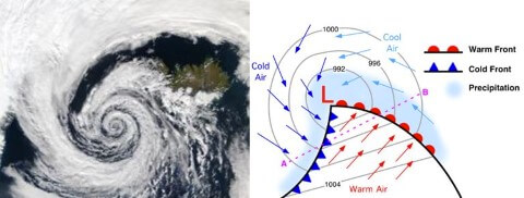
- According to this theory, warm-humid air masses from the tropics and dry-cold air masses from the poles meet, forming a polar front.
- This occurs over sub-tropical high, sub-polar low pressure belts and along the Tropopause.
- The cold air pushes the warm air upwards, creating a void.
- The surrounding air rushes in, creating a cyclone that advances with the westerlies.
- In the northern hemisphere, warm air blows from the south and cold air from the north of the front.
- The pressure drop along the front causes warm air to move northwards and cold air to move southwards, creating an anticlockwise cyclonic circulation.
- This leads to a well-developed extratropical cyclone with a warm front and a cold front.
- There are pockets of warm air wedged between the forward and rear cold air, which cause precipitation.
- The cold front approaches the warm air from behind and lifts it up, causing cumulus clouds to develop.
- The cold front moves faster than the warm front, ultimately overtaking it and occluding the front.
- Individual frontal cyclones exist for about 3 to 10 days moving in a generally west to east direction.
- The movement of the weather system is controlled by the orientation of the polar jet stream in the upper troposphere.
Seasonal Occurrence of Temperate Cyclones
- Temperate cyclones mostly occur in winter, late autumn, and spring.
- They are associated with rainstorms and cloudy weather.
- During summer, the paths of temperate cyclones shift northwards.
- There are only a few temperate cyclones over the sub-tropics and the warm temperate zone during summer.
- A high concentration of storms occurs over Bering Strait, USA, and Russian Arctic and sub-Arctic zone during summer.
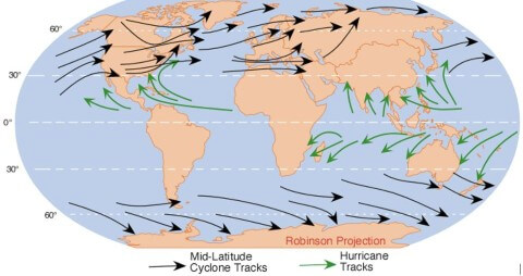
Distribution of Temperate Cyclones
- Temperate cyclones extend over Sierra Nevada, Colorado, Eastern Canadian Rockies, and the Great Lakes region in the USA and Canada.
- The belt of temperate cyclones extends from Iceland to the Barents Sea and continues over Russia and Siberia.
- Winter storms occur over the Baltic Sea.
- The Mediterranean basin also experiences temperate cyclones that extend up to Russia and even up to India in winters (called western disturbances).
- The Antarctic frontal zone also experiences temperate cyclones.
Characteristics of Temperate Cyclones
- Size and Shape
- The temperate cyclones are asymmetrical and shaped like an inverted ‘V’.
- They stretch over 500 to 600 km.
- They may spread over 2500 km over North America (Polar Vortex).
- They have a height of 8 to 11 km.
- Wind Velocity And Strength
- The wind strength is more in eastern and southern portions, more over North America compared to Europe.
- The wind velocity increases with the approach but decreases after the cyclone has passed.
- Orientation And Movement
- Jet stream plays a major role in temperate cyclonogenesis.
- Jet stream also influences the path of temperate cyclones.
- Temperate cyclones move with the westerlies (Jet Streams) and are oriented east-west.
- If the storm front is east-west, the center moves swiftly eastwards.
- If the storm front is directed northwards, the center moves towards the north, but after two or three days, the pressure difference declines and the cyclone dissipates.
- If the storm front is directed southwards, the center moves quite deep southwards, sometimes causing the Mediterranean cyclones or Western Disturbances, which are important as they bring rains to North-West India – Punjab, Haryana.
- Structure
- The north-western sector is the cold sector and the north-eastern sector is the warm sector (Because cold air masses in north and warm air masses in south push against each other and rotate anti-clockwise in northern hemisphere).
Associated Weather
- The halo around the sun and moon is caused by the refraction and reflection of light by ice crystals in the upper atmosphere.
- The warm front brings in warm and moist air which rises over the cold air ahead of it, leading to the formation of clouds and precipitation.
- The cold front is associated with a steep pressure gradient and often results in the formation of thunderstorms due to the rapid lifting of warm air.
- Anticyclones are high-pressure systems that are generally associated with clear and stable weather conditions. They often follow the passage of a temperate cyclone.