


- Africa is the second largest continent in the world with an area of 30,330,000 sq km.
- Africa covers 6% of the Earth’s total surface area and 20.4% of its total land area.
- Africa is known as the “Mother Continent” as it is the oldest inhabited continent on Earth.
- The equator, the Tropic of Capricorn, and the Tropic of Cancer all pass through Africa.
- The Greenwich Meridian passes through the western part of Africa.
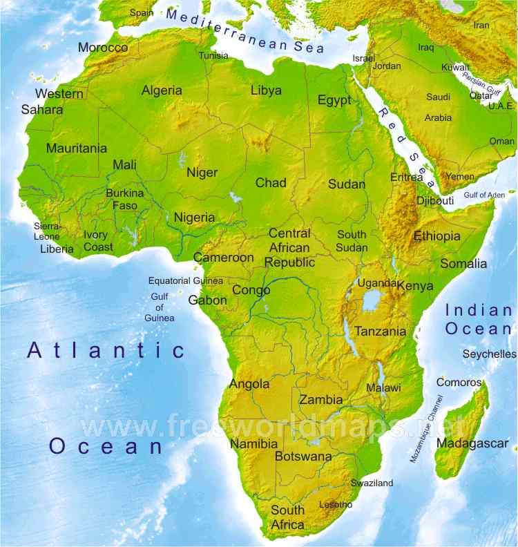
- Algeria is Africa’s largest country by area, and Nigeria is the most populous.
- Seychelles is the smallest country in Africa.
- Africa is separated from Europe by the Mediterranean Sea and joined with Asia at its northeast extreme end by the Isthmus of Suez, which is 163 km wide.
- Africa is bounded by the Red Sea along the Sinai Peninsula to the northeast, the Indian Ocean to the southeast, and the Atlantic Ocean to the west.
- Africa is divided almost equally by the Equator.
- Africa has eight major physical regions: the Sahara, the Sahel, the Ethiopian Highlands, the savanna, the Swahili Coast, the rain forest, the African Great Lakes, and Southern Africa.
- Africa has 54 recognized sovereign states.

Regional divisions of Africa
- The physiographic divisions of Africa are into the following six regions:
- Northern Africa
- Northeast Africa
- Eastern Africa
- Central Africa
- Southern Africa
- Western Africa

- Northern Africa:
- It extends from Algeria in the north, through, the Canary Islands, Santa Cruz de Tenerife, Ceuta, Egypt, Libya, Madeira, Melilla, Morocco, Sudan, and Tunisia, It reaches up to Western Sahara.
- Northeast Africa:
- Also called the Horn of Africa
- Includes Djibouti, Eritrea, Ethiopia, and Somalia
- Extends several hundred kilometers into the Arabian Sea and lies along the southern side of the Gulf of Aden
- Eastern Africa:
- Extensive area from the Red Sea and the Horn of Africa to Mozambique
- Includes Burundi, Comoros, Kenya, Madagascar, Malawi, Mauritius, Mayotte, Mozambique, Réunion, Rwanda, Seychelles, South Sudan, Tanzania, Uganda, Zambia, Zimbabwe
- Central Africa:
- Large landmass in the middle of the continent
- Includes Angola, Cameroon, Central African Republic, Chad, Republic of the Congo, Democratic Republic of the Congo, Equatorial Guinea, Gabon, São Tomé, and Príncipe
- Southern Africa:
- Southernmost part of the continent
- Includes Botswana, Lesotho, Namibia, South Africa, and Swaziland
- Western Africa:
- Situated roughly at 100° E longitude
- Includes Benin, Burkina Faso, Cape Verde, Gambia, Guinea, Guinea-Bissau, Ivory Coast, Liberia, Mali, Mauritania, Niger, Nigeria, Saint Helena, Senegal, Sierra Leone, and Togo
Major Physical Divisions of Africa
- The major physical divisions of African continent are:
- The Plateau
- The Fold Mountains
- Deserts
- Rivers
- Islands
The Plateaus in Africa
- Saucer-shaped and steep-edged plateaus facing towards the coast
- Extend from Guinea coast to Somali Land and north Sahara to the Cape Province
- Divided into three groups: South African plateau, East African plateau, and Ethiopian Highlands
- South African plateau:
- Bounded east, west, and south by bands of high ground which fall steeply to the coasts
- Connected towards the northeast with the East African plateau
- East African plateau:
- Has a slightly greater average elevation than the South African plateau
- Formed by a widening out of the eastern axis of high ground, subdivided into a number of zones running north and south
- Ethiopian Highlands:
- Rugged mass of mountains forming the largest continuous area of its altitude in the whole continent
- Other African Plateaus:
- Katanga Plateau: farming, ranching, resource-rich with copper and uranium deposits
- Ethiopian Plateau: includes Lake Tana, cooler despite close to the equator
- Great Karoo: semi-desert region
- Bie Plateau: important for copper, agriculture, and cattle rearing
- Adamawa Plateau: savannah vegetation, bauxite deposits

Mountains
- Africa is famous for its newly formed folded mountains.
- Prominent mountain ranges with some of the very high raised mountain peaks are the specialty of African Continents.
- Atlas Mountains:
- Stretching across Morocco, Algeria, and Tunisia, subdivided into high, medium, and Anti-Atlas groups, with Jebel Toubkal as the highest peak at 4165 m.
- Ruwenzori Mountains:
- Borders Uganda and Congo (Kinshasa), known as “Mountains of the Moon,” with Mount Stanley at Margherita Peak (5119 m) as the highest peak.
- Mount Elgon:
- Extinct volcanic mountain on the Uganda-Kenya border, with a height of 4321 km and a 610 m deep crater.
- Tibesti Mountains:
- Situated in northern Chad, spreading west into northern Niger and southern border area of Libya, with a volcanic origin and the highest peak at 3415 m.
- Ahaggar Mountains:
- Located in southern Algeria near the Tropic of Cancer, with Mount Tahat as the highest peak at 2918 m and a volcanic formation.
- Drakensberg:
- Located in the eastern part of South Africa, the highest in Southern Africa, with Thabana Ntlenyana at 3482 m as the highest peak.
- Mount Kenya:
- Located in central Kenya, the highest mountain in Kenya and the second-highest in Africa, with Batian (5199m), Nelion (5188m), and Lenana (4958m) as the highest peaks.
- Kilimanjaro:
- Inactive stratovolcano in northeastern Tanzania, the tallest free-standing mountain rise in the world, and includes the highest peak in Africa at 5895 meters.
The Deserts of Africa
- Sahara Desert:
- Largest hot desert in the world.
- Stretches across North Africa.
- Covers an area of approx. 3,320,000 sq. miles.
- Major countries contributing land: Libya, Algeria, Egypt, Tunisia, Chad, Morocco, Eritrea, Niger, Mauritania, Mali, and Sudan.
- Topographical features include:
- Shallow, seasonally inundated basins (chotts and dayas) and large oasis depressions.
- Extensive gravel-covered plains (serirs or regs).
- Rock-strewn plateaus (hammadas).
- Abrupt mountains.
- Sand sheets, dunes, sand seas (ergs) and oases (lush green areas).
- Subtropical HP zone, Tuareg tribes.
- Nubian Desert:
- Eastern region of Sahara desert, between the Nile and the Red Sea.
- Virtually no rainfall.
- No oases.
- Located in Egypt.
- Covers an area of 1,54,000 sq. miles approx.
- Separated from Libyan desert by Nile river.
- Rocky desert.
- Namib Desert:
- Cool coastal desert in southern Africa.
- Believed to be as old as 55 million years, the oldest desert in the world.
- High sand dunes and point where desert meets the sea are key attractions of UNESCO World Heritage Site.
- Off-shore trade wind and cold Benguella current.
- Sandy desert.
- Hottentots tribes.
- Kalahari Desert:
- Lies in the south and the Namib Desert is along the south-west shore of Africa.
- Covers an area of 3,50,000 sq. miles and encroaches on parts of Botswana, Namibia, Zambia, Angola, and Zimbabwe.
- Topographical features include:
- Rain-shadow effect.
- Stony-rocky desert.
- San People have lived in the difficult terrain.
- Famous for diamond mining.
- Bushmen tribe (the oldest surviving tribal group of Africa).
- Okavango Delta:
- One of the very few major interior delta systems that do not flow into a sea or ocean.
- Comprises permanent marshlands and seasonally flooded plains.
- Delta covers part of the Kalahari Desert and owes its existence to the Okavango (Kavango) River.
- Home to some of the world’s most endangered species of large mammal, such as the cheetah, white rhinoceros, black rhinoceros, African wild dog, and lion.
The Islands of Africa
- Madagascar (Malagasy) in the Indian Ocean
- Canary Islands in the Atlantic Ocean
- Saint Helena Island in the South Atlantic Ocean
- Zanzibar, Tanzania in the Indian Ocean
- Madeira, Portugal
- Cape Verde
- Mauritius
- Reunion, France
- Comoros, France
- Seychelles
- British overseas territories: islands between Africa and Latin America
- Ascension Islands – UK military base
- St. Helena Islands – the exile of Napoleon
- Tristan De Cunha Island – the most remote island of the world
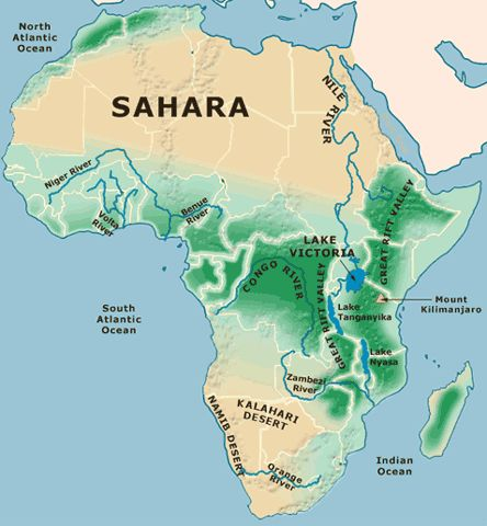
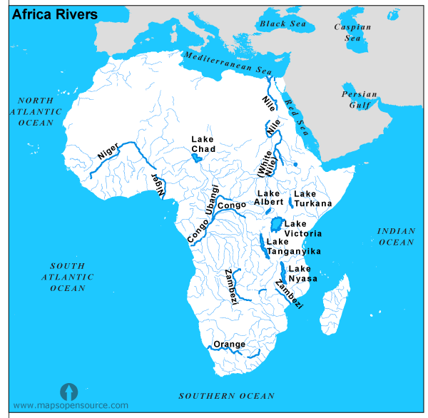
The Rivers of Africa
- The most important ones are the Nile, the Congo, the Niger, and the Zambezi.
1
- River Nile:
- Longest river in the world
- Starts from streams in equatorial rainforest of Lake Victoria and Ruwenzori Mountain region
- Flows through dry Sahara Desert of Egypt
- Joins with Blue Nile at Khartoum, which starts from Lake Tana on Ethiopian Highlands
- Egypt is called the gift of the Nile because without it, the country would have been a desert
- Cities on the Nile include Cairo, Giza, and Khartoum
- River Congo or Zaire:
- Second-longest river in Africa
- Starts from southwest of Lake Tanganyika and flows into the Atlantic Ocean
- Basin covered with dense jungle, not navigable due to rapids and waterfalls
- Flows through Pigmy tribes’ region
- Crosses the equator twice
- River Niger:
- Chief river of West Africa
- Rises from Fout Djllon Mountain, flows north, turns south to form a wide arc, and finally joins the Gulf of Guinea
- River Zambezi:
- Flows into the Indian Ocean
- Victoria Falls located at the head of a long gorge on this river
- River Limpopo:
- Flows into the Indian Ocean
- Crosses the Tropic of Capricorn twice
- River Orange:
- Flows from the Drakensberg Mountains into the Atlantic Ocean
Lakes of Africa
- Lake Victoria is the second-largest freshwater lake in the world, the largest in Africa, and the source of the White Nile.
- The Great Rift Valley has a string of lakes, including Lake Tanganyika and Lake Nyasa (Malawi).
- Lake Tana, located on the Ethiopian Plateau, is the source of the Blue Nile.
- Lake Chad, located in the southern edge of the Sahara Desert, is in a region of inland drainage and the largest river in the area is the Chari River.
- Lake Nasser is a man-made lake located between Egypt and Sudan, situated on the River Nile.
- Lake Kariba is situated in the southernmost part of Africa, on the Zambezi River, and is the largest producer of hydroelectricity in Africa.
- Lake Assal is situated in Djibouti and is the lowest point in Africa.
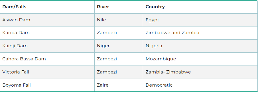
Important Dams and Waterfalls of Africa
Climate
- Africa experiences highly variable climate due to its large size.
- Africa has the following climatic zones based on prevailing weather conditions:
- Equatorial rainforest climate
- Temperate grasslands
- Mediterranean Hot Summer
- Hot Desert Climate
- Tropical Wet/Dry (Savanna) Climate.
Natural Vegetation
- There are extensive areas in Africa where few people live and where natural vegetation and wild animals have not been disrupted by such activities as farming or the raising of livestock. In some parts of the continent, large forest reserves have been established.
- Tropical Rain Forests:
- Cover less than a tenth of Africa
- Heavy rain throughout the year
- Multiple layers of vegetation, including tall trees, shrubs, and vines
- Yield pulp, timber, and cabinet woods like mahogany, ebony, and teak
- Home to oil palms, rubber-producing trees and vines, orchids, and lilies
- Tropical Savannas:
- Cover about one-third of Africa
- Mainly grassy areas with scattered trees or shrubs
- Coarse grasses up to 12 feet high
- Deciduous trees and evergreens, such as oil palms and rubber trees, found near the forest border
- Rainfall decreases away from the equator, leading to a dry season
- Sudan-type Climate:
- Zone with a definite dry season
- Tropical Grassland or Savanna vegetation
- Thick and coarse grasses, including tall elephant grass
- Tropical Steppes and Deserts:
- Increased aridity and longer dry seasons
- Regions with short grasses only
- Thorny acacias, dwarf palms, and jujube trees found here
- Steppes bordering on deserts have widely scattered bunches of grasses, but no trees
- Oases contain date palms, fig-trees, willows, poplars, and tamarisks
- Mediterranean Forests:
- Found along the northern and southern coasts of Africa
- Shrubs and small trees, both deciduous and evergreen
- Plants can withstand long, dry summers with waxy, leathery leaves and long taproots
- Cork oak, olive trees, cedars, and pines grown in the north; laurels, cedars, and ironwood in the south
- Grasses and low flowering plants grow only during the rainy months
- Montane Forests:
- Found in highlands, particularly in Ethiopia and the mountains of the Great Rift Valley
- Vegetation varies depending on elevation, latitude, and wind direction
- Valuable timber and cabinet woods, bamboo, and wild varieties of coffee and banana found here
- Thick evergreen forests cover slopes of the mountain
- High Veld:
- Temperate grassland between 3,500 and 11,000 feet above sea level in southern Africa
- Mangrove Forests:
- Found mostly along the African coast, particularly the Gulf of Guinea
- Trees tailored to life in muddy estuaries and tidal flats
- Swamps and marshes occur along larger rivers and lakes of western and central Africa
- Papyrus, tall grasses, and lotus are the most common plants.
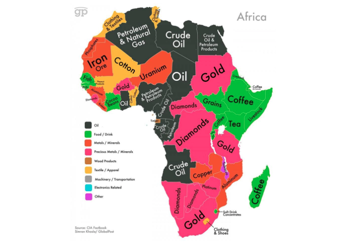
Mineral Reserves of Africa
- Petroleum
- Coal
- Iron
- Diamonds
- Gold
- Uranium, Platinum
Famous Tribes in Africa:
- Zulu, South Africa.
- Xhosa, South Africa
- Karo, Ethiopia.
- Hamar, Ethiopia
- Yoruba, Nigeria.
- Himba, Namibia.
- San Bushmen, Kenya
- Samburu, Kenya
- Maasai, Kenya, and Tanzania.
- Hadzabe, Tanzania