


- Fluvial landforms are generated by running water, mainly rivers
- Fluvial derives from the Latin word ‘fluvius’ meaning river
- Fluvial landforms range in size from small features like rills to large rivers and their drainage basins
- About 68% of the Earth’s land surface is drained by rivers flowing to the oceans
- Rivers generally have their source in upland regions with a slope down for the run-offs
- Uplands form the catchment areas of the rivers and the crest of mountains becomes the divide or watershed from which the streams flow down the slope
- The initial stream that exists as a consequence of the slope is called the consequent stream
- The consequent stream is joined by several tributaries from either side as it wears down the surface
- The drainage basin or watershed is a fundamental landscape unit in fluvial geomorphology
- A drainage basin contains a primary or trunk river and its tributaries
- Various aspects of fluvial erosive action include:
- Hydration: the force of running water wearing down rocks.
- Corrosion/Solution: chemical action that leads to weathering.
- Attrition: wear and tear of transported material when they roll and collide with one another.
- Corrasion or abrasion: solid river load striking against rocks and wearing them down.
- Downcutting (vertical erosion): erosion of the base of a stream, which leads to valley deepening.
- Lateral erosion: erosion of the walls of a stream, which leads to valley widening.
- Headward erosion: erosion at the origin of a stream channel, which causes the origin to move back away from the direction of the stream flow, and so causes the stream channel to lengthen.
- Hydraulic Action: mechanical loosening and sweeping away of materials by river water, mainly by surging into the crevices and cracks of rocks and disintegrating them.
- Braiding: the main water channel splitting into multiple, narrower channels. A braided river consists of a network of river channels separated by small, often temporary, islands called braid bars. Braided streams occur in rivers with low slope and/or large sediment load.
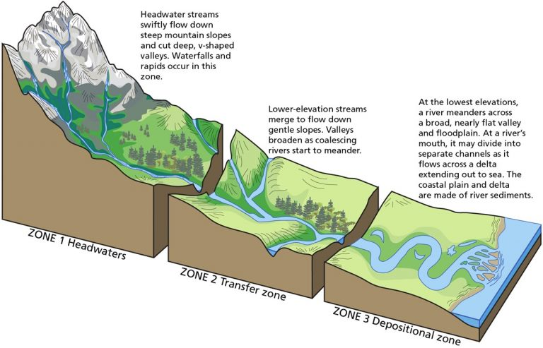
River course
Youth
- Streams are few during this stage with poor integration and flow over original slopes.
- The valley developed is deep, narrow, and distinctly V-shaped with no floodplains or with very narrow floodplains.
- Downcutting predominates over lateral corrasion.
- Stream divides are broad and flat with marshes, swamps, and lakes.
- Outstanding features developed in this stage include gorges, canyons, waterfalls, rapids, and river capture.
Mature
- During this stage, streams are plenty with good integration.
- Lateral corrasion tends to replace vertical corrasion.
- The valleys are still V-shaped but wide and deep due to active erosion of the banks.
- Trunk streams are broad enough to have wider floodplains within which streams may flow in meanders confined within the valley.
- Swamps and marshes of youth stage, as well as flat and broad inter-stream areas, disappear.
- The stream divides turn sharp.
- Waterfalls and rapids disappear.
- Meander and slip off slopes are the characteristic features of this stage.
Old
- The river moving downstream across a broad level plain is heavy with sediments.
- Vertical corrasion almost ceases in this stage though lateral corrasion still goes on to erode its banks further.
- Smaller tributaries during old age are few with gentle gradients.
- Streams meander freely over vast floodplains.
- Divides are broad and flat with lakes, swamps, and marshes.
- Depositional features predominate in this stage.
- Most of the landscape is at or slightly above sea level.
- Characteristic features of this stage are floodplains, oxbow lakes, natural levees, and Delta etc.
Fluvial Landforms – Erosional
- Splash erosion:
- the first stage in the erosion process caused by the bombardment of soil surface by rain drops.
- Rain drops displace soil particles and destroy soil structure.
- Sheet erosion:
- occurs as a shallow sheet of water flowing over the ground surface, resulting in the removal of a uniform layer of soil from the soil surface.
- Sheet flow is the cause of sheet erosion.
- Rills:
- shallow channels created by the erosion of flowing water in soil.
- Gullies:
- large rills that cannot easily be removed by tilling the soil.
- Rivulet:
- a small stream
- Ravine:
- a narrow landform often formed by streambank erosion, larger than gullies but smaller than valleys
- River valley:
- an extended depression on the ground where a stream flows throughout its course
- Valleys start as small, narrow rills and gradually develop into long, wide gullies
- Gullies deepen, widen, and lengthen to form valleys
- Different types of valleys can be recognized, such as V-shaped valleys, gorges, canyons, etc.
- I-shaped valley/gorge:
- valley sides are almost parallel, forming an “I” shape; gorges have very steep to straight sides and are almost equal in width at the top and bottom
- Gorges are formed in hard rocks
- Example of a gorge: Indus Gorge in Kashmir
- Canyon:
- a wider variant of the gorge with steep step-like side slopes
- Canyons commonly form in horizontal bedded sedimentary rocks
- Grand Canyon carved by Colorado River, USA is an example of a canyon
- V-shaped valley:
- deep, narrow and distinctly V-shaped, formed by vertical corrasion
- Interlocking spurs:
- projections of high land that alternate from either side of a V-shaped valley
- Waterfalls & Rapid:
- Waterfalls occur when a river plunges down from a height
- They are formed due to several factors like relative rock resistance and differences in topographic relief
- The force of water from the waterfall can create a plunge pool beneath it
- Rapids are formed by an abrupt change in the river’s gradient
- Waterfalls and rapids are transitory landforms and will recede gradually over time.
- Potholes & Plunge Pool:
- Potholes are circular depressions on rocky beds of hill-streams.
- They are formed by stream erosion and abrasion of rock fragments.
- Small and shallow depressions are formed initially.
- Pebbles and boulders rotate in the depressions due to flowing water, leading to growth in dimensions.
- Depressions join eventually, deepening the stream valley.
- Large and deep potholes form at the foot of waterfalls due to the sheer impact of water and rotation of boulders.
- These are called plunge pools.
- Plunge pools help in deepening of valleys.
- Cataract:
- Waterfalls on large rivers
- Usually applied to sections of rapidly flowing rivers with a sheer drop
- Powerful and dangerous waterfalls
- Ait/Eyot:
- Small islands found in rivers
- Typically formed by sediment deposition in the water
- Long and narrow in shape, may become permanent islands with vegetation
- May be eroded and result in another ait, a channel with many aits is called a braided channel
- Incised/Entrenched Meanders:
- Found cut in hard rocks
- Very deep and wide
- Formed from original gentle surfaces in initial stages of stream development
- Meander loops get entrenched into rocks due to erosion or gradual uplift of land
- Widened and deepened over time, can be found as gorges and canyons in areas with hard rocks
- Indication of original land surface over which streams developed
- Impact of river rejuvenation.
- Structural Benches:
- Step-like sequence of geomorphic surfaces
- Differential erosion of alternately arranged hard and soft rocks forming step-like valleys
- Structural benches formed due to differential erosion of alternate bands of hard and soft rock beds
- Lithological control in the rate of erosion and consequent development of benches
- River Terraces:
- Surfaces relating to old valley floor or floodplain levels
- Bedrock surfaces without any alluvial cover or alluvial terraces consisting of stream deposits
- Products of erosion resulting from vertical erosion by the stream into its own depositional floodplain
- Different terraces found at different heights indicating former river bed levels
- Paired terraces occur at the same elevation on either side of the river
- Peneplain:
- Low-relief plain formed as a result of stream erosion
- Represents a near-final stage of fluvial erosion during times of extended tectonic stability
- Drainage Basin:
- Also called catchment, catchment area, catchment basin, river basin, or water basin
- Includes both streams/rivers and land surface
- Collects all the water within the area covered by the basin and channels it to a single point
- In closed drainage basins, water converges to a single point inside the basin known as a sink
- Drainage Divide:
- Adjacent drainage basins are separated from one another by a drainage divide.
- Drainage divide is usually a ridge or a high platform.
- Drainage divide is conspicuous in case of youthful topography (Himalayas), and it is not well marked in plains and senile topography.
- Drainage Patterns:
- Drainage pattern refers to the shape of a river course during its erosional cycle
- It’s determined by topography, resistance and strength of base rocks, and land gradient
- Types of drainage patterns:
- Dendritic: most common, branches out like a tree, e.g. Indus River
- Trellis: primary tributaries flow parallel and joined by secondary tributaries at right angles, e.g. Appalachian Mountains and Seine River in France
- Parallel: observed in steep sloping regions, tributaries run parallel, e.g. Lesser Himalaya
- Rectangular: develops on rocks of uniform resistance with two directions of joining at right angles, e.g. Colorado River
- Angular: observed in foothill regions where bedrock joints and faults intersect at acute angles, e.g. Ladakh and Tibet streams
- Radial: rivers originate from a hill and flow in all directions, e.g. Amarkantak Range
- Centripetal: rivers discharge in all directions in a lake or depression, e.g. streams in Ladakh, Tibet, and Loktak Lake in Manipur
- Annular: streams follow a roughly circular path along a belt of weak rock, e.g. Black Hill streams in South Dakota, USA.
Fluvial Landforms – Depositional
- Fluvial depositional landforms are created by river sediments from erosion in the upper course of rivers.
- Weathering and erosion of rocks and cliffs occur in the youth stage or upper course of the river.
- The river brings down a heavy load of sediments from the upper course as it moves downstream on a level plain.
- The decreasing stream velocity in the lower course reduces the transporting power of the streams, leading to the deposition of sediment.
- Coarser materials are deposited first, followed by finer silt towards the mouth of the river.
- This depositional process creates various landforms through fluvial action, including Delta, Levees, and Flood Plain.
- Alluvial Fans and Cones:
- Alluvial fans are cone-shaped depositional landforms built up by streams heavy with sediment load.
- They are formed when streams flowing from mountains break into foot slope plains of low gradient.
- Normally, very coarse load is carried by streams flowing over mountain slopes, but this load gets dumped as it becomes too heavy to be carried over gentler gradients by the streams.
- The dumped load spreads as a broad low to a high cone-shaped deposit called an alluvial fan that appears as a series of continuous fans.
- Alluvial fans in humid areas show normally low cones with a gentle slope from head to toe, while they appear as high cones with a steep slope in arid and semi-arid climates.
- Floodplains:
- Floodplain is a landform created by river deposition.
- Deposition and erosion are responsible for the development of floodplains and valleys, respectively.
- Rivers in the lower course carry large amounts of sediment.
- Large materials are deposited first when the stream channel breaks into a gentler slope.
- Fine sediments like sand, silt, and clay are carried over gentler channels by slow-moving waters.
- During floods, sediments are spread over low-lying adjacent areas, gradually building up a floodplain.
- In plains, channels occasionally shift and change course, leaving cut-off courses that are filled up by coarse deposits.
- Flood deposits carry finer materials like silt and clay.
- Active floodplain is the riverbed made of river deposits.
- Inactive floodplain above the banks contains flood deposits and channel deposits.
- The floodplains in a delta are called delta plains.
- Doab:
- Doab is the tract of land between two converging rivers.
- Doab is a term used in South Asia particularly in India and Pakistan to refer to ” tongue” or tract of land lying between two converging rivers.
- Natural Levees:
- Natural Levees are low, linear and parallel ridges of coarse deposits found along the banks of large rivers.
- They are formed by the deposition action of the stream and appear as natural embankments.
- During flooding, water is spilt over the bank and as the flow speed decreases, large sediments are deposited along the bank as ridges.
- The levee deposits are coarser and high near the banks, sloping gently away from the river.
- Series of natural levees can form when rivers shift laterally.
- Artificial embankments are formed on the levees to minimize the risk of floods.
- Sudden bursts in the banks due to water pressure can cause disastrous floods, as seen in the example of the Hwang Ho river, also known as China’s sorrow.
- Point Bars & Cut Banks:
- Point Bar is a depositional feature associated with floodplain
- Also known as meander bars, they are formed by alluvium accumulation on the inside bends of streams and rivers below the slip-off slope.
- Found on the convex side of meanders of large rivers, they are almost uniform in profile and width, and contain mixed sizes of sediments.
- Long and narrow depressions can be found in between the point bars where there is more than one ridge.
- Rivers build a series of point bars depending upon the water flow and supply of sediment.
- Erosion takes place on the concave side of the bank, while point bars are built by the rivers on the convex side.
- Cut banks are found on the outside of a bend in a river, caused by the moving water of the river wearing away the earth.
- Meanders:
- Meanders are loop-like channel patterns that develop over flood and delta plains of large rivers
- Active deposition happens along the convex bank while undercutting occurs along the concave bank in meanders
- If there is no deposition or erosion, meandering tendency is reduced
- The concave bank is called a cut-off bank and appears as a steep scarp, while the convex bank presents a long, gentle profile called the slip-off bank
- Oxbow Lake:
- Oxbow lakes are independent water bodies formed when deep meander loops get cut-off due to erosion at inflection points
- Oxbow lakes can get silted up and turn into swamps, eventually drying up over time due to natural processes.
- Pools:
- Deep areas with slow current in a stream.
- Created by the vertical force of water falling over logs or boulders.
- Provide depth and still water.
- Riffles:
- Shallow areas with fast, turbulent water in a stream.
- Created by rocks that agitate the water flow.
- Provide protection, food deposition, and shelter.
- Depths vary depending on the size of the stream, ranging from 1 inch to 1 meter deep.
- High dissolved oxygen concentration due to the turbulence and streamflow.
- Bluff:
- Small, rounded cliff overlooking a body of water or where a body of water once stood
- Ridge of land extending into the air
- Braided Channels:
- Network of river channels divided into multiple threads and separated by small and often temporary islands called eyots
- Commonly found where water velocity is low and the river is heavy with sediment load
- Deposition and lateral erosion of banks are essential for the formation of the braided pattern
- Formation of central bars due to selective deposition of coarser material which diverts the flow towards the banks causing extensive lateral erosion
- As the valley widens due to continuous lateral erosion, the water column is reduced and more and more materials get deposited as islands and lateral bars developing a number of separate channels of water flow.
- Delta:
- Deltas are fan-shaped alluvial areas, resembling an alluvial fan, formed by sediment deposition from rivers at their mouths into the sea
- Deltas extend sideways and seaward at an amazing rate
- Deltas are well-sorted with clear stratification, with coarse sediments deposited first and finer sediments carried further out to sea
- Types of Deltas:
- Bird’s foot delta: long, stretching distributary channels branching outward resembling a bird’s foot
- Arcuate delta: a fan-shaped delta with a curved or bowed margin facing the sea
- Cuspate delta: a delta with tooth-like projections at its mouth, formed where the river flows into a stable water body
- Estuarine delta: a delta partly submerged in the coastal waters due to a drowned valley or rise in sea level
- Conditions favorable for delta formation:
- Active vertical and lateral erosion in the upper course of the river to provide extensive sediments
- Sheltered coast with shallow adjoining sea
- No large lakes in the river to filter off sediments
- No strong current running at right angles to the river mouth to wash away sediments