


Pressure:
- Air in a column exerts weight as pressure on the earth’s surface
- The weight of the column of air at a certain place and time is called atmospheric pressure
- Atmospheric pressure is measured using a barometer
- The unit of measurement for atmospheric pressure is millibar
- One millibar equals the force of approximately one gram per square centimeter
Factors Controlling Pressure Systems
- Two main causes of pressure differences in high and low-pressure systems: thermal and dynamic factors
- Thermal factors:
- heating causes air to expand and decrease in density, leading to low pressure; cooling causes air to contract, increase in density, and lead to high pressure
- Formation of equatorial low and polar highs are examples of thermal lows and highs, respectively
- Dynamic factors:
- They also play a role in pressure belt formation, including pressure gradient forces and the Coriolis force arising from the rotation of the Earth
Pressure Gradient
- Pressure gradient is the rate of change of atmospheric pressure between two points on Earth’s surface
- It is indicated on weather charts by the spacing of isobars
- Close spacing of isobars indicates a strong pressure gradient
- Wide spacing of isobars suggests a weak pressure gradient
Vertical Distribution
- The columnar distribution of atmospheric pressure is called the vertical distribution of pressure
- The mass of air above compresses the air below, making the lower layers of the atmosphere denser and exerting more pressure
- Conversely, higher layers have lower density and lower pressure
- Air pressure at a given place and time is determined by air temperature, water vapor content, and gravitational pull of the Earth
- These factors vary with height, causing a variation in the rate of decrease in air pressure with increasing altitude
- Rising pressure indicates fine and settled weather
- Falling pressure indicates unstable and cloudy weather
Horizontal Distribution
- The factors responsible for variation in the horizontal distribution of pressure are as follows:
- Air temperature – Equator Polar regions
- The earth’s rotation – Coriolis force
- Presence of water vapor – Inversely related to pressure
- Air Temperature:
- Earth is not heated uniformly due to unequal distribution of insolation and differential heating and cooling of land and water surfaces
- Air pressure is low in equatorial regions and high in polar regions
- Low air pressure in equatorial regions is due to hot air ascending and decreasing in temperature, causing thinness of air at the surface
- In polar regions, cold air is dense and descends, causing an increase in pressure
- The Earth’s Rotation:
- Earth’s rotation generates centrifugal force, causing deflection of air and a decrease in pressure
- Low-pressure belts of subpolar regions and high-pressure belts of subtropical regions are created by Earth’s rotation
- Presence of Water Vapour:
- Air with more water vapour has lower pressure, and air with less water vapor has higher pressure
World Pressure Belts
- On the earth’s surface, there are seven pressure belts. They are –
- Equatorial Low
- The two Sub-tropical Highs
- The two Sub-polar Lows
- The two Polar Highs
- Equatorial Low Pressure Belts:
- The low-pressure belt extends from 0 to 5° North and South of the Equator
- This area receives intense heating due to the vertical rays of the sun
- The air expands and rises as convection currents, causing low pressure to develop
- This low-pressure belt is known as doldrums
- Doldrums are characterized by a zone of total calm without any breeze
- Sub-tropical High Pressure Belts:
- At about 30° North and South of the Equator lies an area where ascending equatorial air currents descend, creating an area of high pressure
- This area is known as the Horse latitude
- Winds always blow from high pressure to low pressure
- Winds from the subtropical region blow towards the Equator as Trade winds
- Another wind blows towards Sub-Polar Low-Pressure as Westerlies
- Circum-polar Low Pressure Belts:
- Circum-polar Low-Pressure Belts are located between 60° and 70° in each hemisphere
- In the Sub-tropical region, descending air gets divided into two parts
- One part blows towards the Equatorial Low-Pressure Belt, the other part blows towards the Circum-polar Low-Pressure Belt
- This zone is marked by the ascent of warm Sub-tropical air over cold polar air blowing from poles
- Due to earth’s rotation, winds surrounding the Polar region blow towards the Equator
- Centrifugal forces create the low-pressure belt, appropriately called Circum-polar Low-Pressure Belt
- This region is marked by violent storms in winter
- Polar High Pressure Areas:
- At the North and South Poles, between 70° to 90° North and South, the temperatures are always extremely low.
- The cold descending air gives rise to high pressures over the Poles.
- These areas of Polar high pressure are known as the Polar Highs.
- These regions are characterized by permanent IceCaps.
The Coriolis Effect
- Coriolis force determines the number of cells the atmosphere of a planet divides into.
- Coriolis force is stronger for more rapid rotation.
- The size of the planet and speed of rotation (and to a lesser extent, the depth of the atmosphere) determine the number of cells.
- Earth’s atmosphere divides into three cells.
- Jupiter has many more cells because it is 12 times larger in diameter and has a day only 12 hours long.
- Coriolis force is very strong.
Atmospheric Circulation
- Atmospheric circulation is the large-scale movement of air and together with ocean circulation is the means by which thermal energy is redistributed on the surface of the Earth.
- Latitudinal circulation:
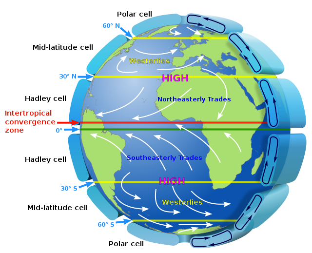
- There are wind belts organized into three cells in each hemisphere: the Hadley cell, the Ferrel cell, and the polar cell.
- These cells exist in both the northern and southern hemispheres and are called latitudinal circulation.
- Latitudinal circulation is a result of the highest solar radiation per unit area falling on the tropics.
- The Hadley Cell:
- Solar heating at the equator is strongest.
- Rising convective air is pushed north and south at the tropopause.
- At ~30deg latitude, air is deflected almost due east by the Coriolis force.
- Air moving down from the north (Ferrel Cell air) meets the deflected air at ~30deg latitude.
- Both air masses meet and descend, warming and drying.
- The return of the air, now a surface wind, to the equator is called the “trade winds”.
- The Ferrel Cell:
- Air rises near 60° latitude and moves southward until it is deflected by Coriolis force to the west.
- The southward moving air meets northerly moving air from the tropical Hadley cell, forcing both to descend.
- This descending air creates the Horse Latitudes at approximately ±30° latitude where deserts are located.
- Northerly moving surface winds are deflected eastward creating the Westerlies which carry heat from lower latitudes to higher mid-latitudes.
- The primary circulation on Earth is driven by the equatorially heated Hadley Cell and the polar cooled Polar Cell.
- The Ferrel cell is an intermediate zone in which weather systems move through driven by the polar jet stream (boundary between Ferrel and Polar cell at tropopause) and the tropical jet stream (boundary between Ferrel and Hadley cells at tropopause).
- The jet streams have irregular paths that drive many cold and warm fronts moving through the Ferrel Cell.
- The Polar Cell:
- Rising air from the 60-degree latitude area in part moves north to the pole.
- Air densifies, converge with other northerly winds from all longitudes, and descends at the pole.
- This creates a “desert” at the north and south poles.
- Longitudinal circulation (Walker circulation):
- Longitudinal circulation is a result of the heat capacity of water, its absorptivity, and its mixing.
- Water absorbs more heat than the land, but its temperature does not rise as greatly as the land.
- Temperature variations on land are greater than on the water due to this difference in heat absorption.
- The Southern Hemisphere has a horizontal air circulation cell called as Walker Cell.
- The Walker circulation is responsible for upwelling along the South American Coast and bringing rains in Australia.
- The Walker circulation is the result of a difference in surface pressure and temperature over the western and eastern tropical Pacific Ocean.
- A pressure gradient from east to the west creates an air circulation from the Eastern pacific to the western Pacific.
- This air circulation displaces surface water towards the western pacific causing cold water from beneath the ocean to move upward.
- Surface waters of the ocean are warm and the water under oceanic beds is cold and contains various types of nutrients that are helpful for aquatic life.
- Sea bird along the coast of South America gets plenty of Phytoplankton and produces Guano which again is helpful for Aquatic life.
- The western pacific and Australia receive precipitation due to Walker circulation.
- El Nino occurs when the Trade Winds are weak, and the warm water of the central Pacific Ocean slowly drifts towards the South American coast and replaces the cool Peruvian current.
- The combined phenomenon of southern oscillation and El Nino is known as ENSO.
- In the years when the ENSO is strong, large-scale variations in weather occur over the world.
- The arid west coast of South America receives heavy rainfall, drought occurs in Australia, and sometimes in India, and floods in China.
- This phenomenon is closely monitored and is used for long-range forecasting in major parts of the world.
Pressure belts in July
- In the northern hemisphere, during summer, with the apparent northward shift of the sun, the thermal equator (belt of highest temperature) is located north of the geographical equator.
- The pressure belts shift slightly north of their annual average locations.
Pressure belts in January
- In winter, pressure belts shift south of their annual mean locations and the opposite conditions prevail in the southern hemisphere.
- The shift in the pressure belts is less in the southern hemisphere due to the predominance of water.
- The distribution of continents and oceans have a marked influence on the distribution of pressure.
- In winter, the continents are cooler than the oceans and tend to develop high-pressure centers.
- In summer, the continents are relatively warmer and develop low pressure.
- The situation is just the reverse with the oceans.