Precipitation
Precipitation is any form of liquid or solid water particles that fall from the atmosphere and reach the surface of the Earth.
Types of precipitation
Types of precipitation include:
- Rain
- Drizzle
- Snow
- Sleet
- Hail

- Rain:
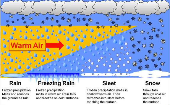
- Rain is precipitation that falls to the surface of the Earth as water droplets.
- Raindrops form around microscopic cloud condensation nuclei, such as a particle of dust or a molecule of pollution.
- Rain that freezes before reaching the ground is called sleet or ice pellets.
- Real raindrops are actually spherical.
- Drizzle:
- Drizzle is a form of light water precipitation where liquid water droplets are smaller than those of rain.
- Drizzle can occur when updrafts in clouds are not strong enough to allow them to produce rain.
- Drizzle usually happens thanks to low-level clouds called ‘stratiform clouds.’
- Drizzle tends to occur more often over colder regions of the subtropics.
- In colder regions, a ‘supercooled drizzle’ or freezing drizzle can occur at temperatures as low as 10 degrees F or lower, depending on how shallow the cold air layer is.
- The drop size of drizzle is less than 0.5 mm.
- Snow:
- Snow consists of ice crystals in a flaky form, having an average density of 0.1g/cc. It usually forms in colder climates and higher altitudes.
- Sleet:
- Sleet is frozen raindrops that are formed when rainfall passes through the air in the atmosphere at subfreezing temperatures. It is a type of precipitation in the form of a mixture of rain and snow.
- Sleet is a frozen rain which forms when rain while falling to the earth passes through a layer of the very cold air mass. Its diameter is greater than 5 mm.
- Hail:
- Hail is a kind of showery precipitation in the form of pellets or lumps that have a size greater than 8mm.
- Hail occurs during violent thunderstorms and falls in the form of small ice pellets.
- The hail consists of concentric layers of ice alternating with layers of snow. Its structure resembles that of an onion.
Rainfall
- Rainfall is precipitation in the liquid form.
- Types of rainfall can be classified into three categories based on the mode of occurrence:
- Convectional
- Orographic or relief
- Cyclonic or frontal
- Convectional rainfall:
- Convectional rainfall results from the heating of the earth’s surface.
- The warm ground heats the air over it, causing the air to rise rapidly into the atmosphere.
- As the air rises, it cools, and water vapor in the air condenses into clouds and precipitation.
- It occurs in areas of intense heat and abundant moisture.
- Solar radiation is the main source of heat to produce convectional currents in the air.
- The belt of doldrums and the equatorial region generally record this type of rainfall.
- This type of rainfall is not much effective for crops as most of the water is drained off in the form of surface drainage.
- Orographic rainfall:
- Orographic precipitation occurs when warm moist air moving across the ocean is forced to rise by large mountains.
- As the air rises, it cools, and the water vapor in the air condenses into water droplets.
- Clouds form and precipitation (rain or snow) occurs on the windward side of the mountain ranges.
- The amount of rainfall starts decreasing after a certain height on the windward side.
- The air is now dry and rises over the top of the mountain.
- As the air moves back down the mountain, it collects moisture from the ground via evaporation.
- This side of the mountain is called the leeward side, and it receives very little precipitation.
- Cyclonic or frontal rainfall:
- Cyclonic or Frontal precipitation occurs when two air masses, warm and moist air mass (warm front) and cool and dry air mass (cold front), converge and move upward.
- The cool air is more dense than the warm air, and the warmer air is forced up over the cool air.
- As the warm air rises, it cools and the water vapor in the air condenses.
- Clouds and precipitation (rain or snow) result from the condensation of water vapor in the air.
World Distribution of Rainfall
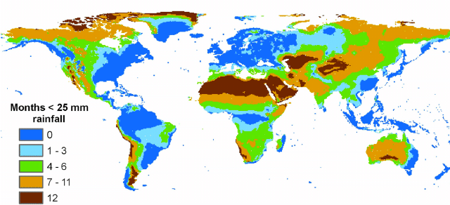
- Rainfall varies across the earth’s surface in terms of amount and seasonality.
- Rainfall decreases as we move away from the equator towards the poles.
- Coastal areas receive more rainfall than the interior of continents.
- Oceans receive more rainfall than landmasses.
- Rainfall on the eastern coasts between latitudes 35° and 40° N and S decreases towards the west, but between 45° and 65° N and S, it is first received on the western margins of the continents and goes on decreasing towards the east.
- Rain is greater on the coastal plain on the windward side of mountains and decreases towards the leeward side.
- Major precipitation regimes of the world are identified based on the total amount of annual precipitation.
- The equatorial belt, windward slopes of mountains along western coasts in the cool temperate zone, and coastal areas of the monsoon land receive heavy rainfall (>200 cm per annum).
- Interior continental areas receive moderate rainfall (100-200 cm per annum).
- The central parts of tropical land and the eastern and interior parts of temperate lands receive rainfall varying between 50-100 cm per annum.
- Areas in the rain shadow zone of the interior of continents and high latitudes receive very low rainfall (<50 cm per annum).
- Rainfall distribution across seasons is an important aspect to judge its effectiveness, with some regions receiving even rainfall throughout the year.


