")
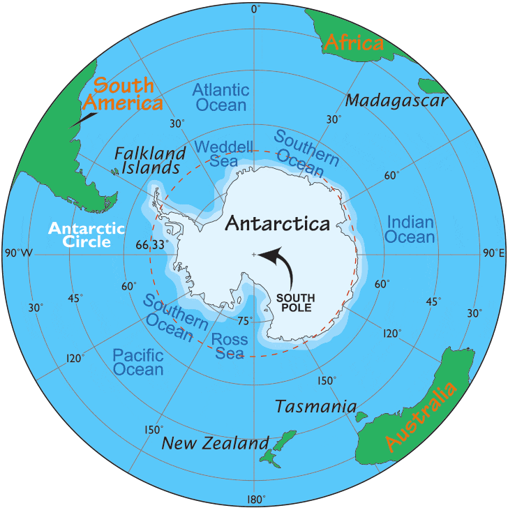
- It is the southernmost continent and lies entirely within the Antarctic Circle spread around the South Pole.
- To the south of India, beyond the Indian Ocean lies the frozen continent of Antarctica.
- The name means – opposite the Arctic.
- It separated from the rest of the world by the icy waters of the Southern Ocean which comprises of the southern portions of the Indian, Atlantic, and Pacific Oceans.
- Its area is over 14 million square kilometers.
- Fifth-largest continent
- Larger than Europe and twice the size of Australia
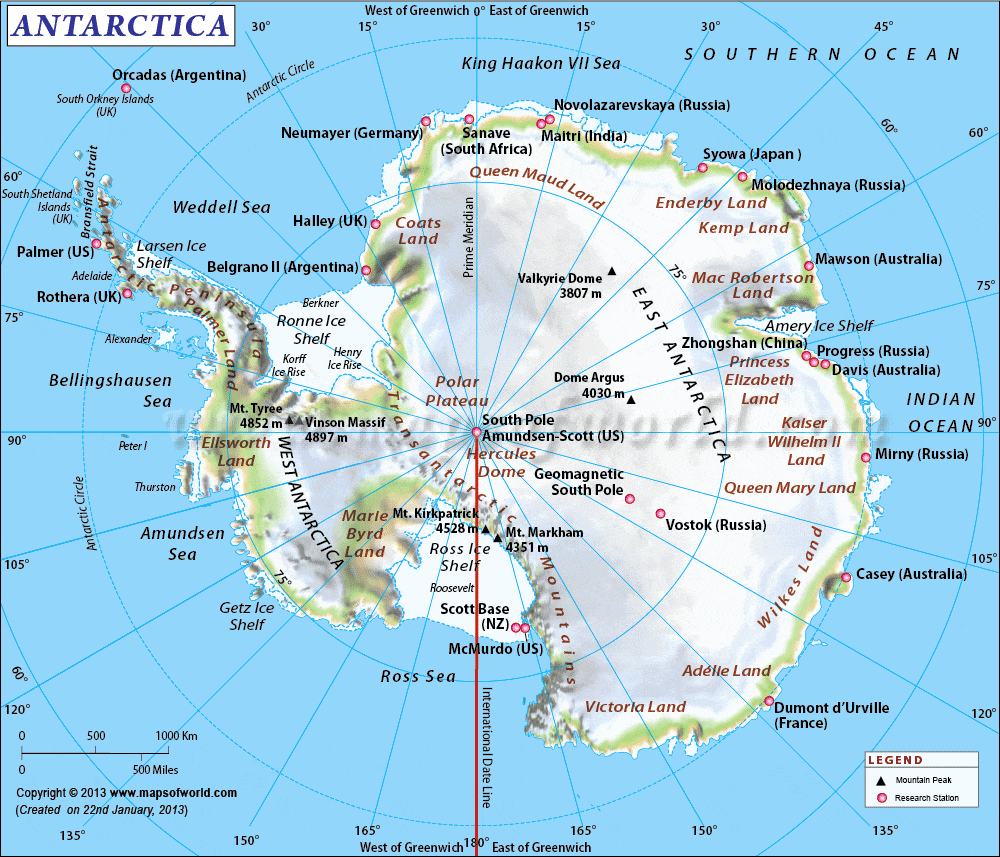
- High plateau that is frozen throughout the year
- No coastal plain
- Contains mountain ranges, peaks, a rift valley, and volcanoes
- Divided into West Antarctica and East Antarctica by the Trans-Antarctic Mountains
- West Antarctica faces the Pacific Ocean and the Antarctic Peninsula points towards South America
- East Antarctica faces the Atlantic and Indian Oceans and contains Mount Erebus, an active volcano
- Completely covered by permanent ice and snow, hence known as the white continent
- Ice cap can be up to 4,000 meters deep in some places
- Valleys between mountain ranges are dry, windy, frozen and barren, sometimes called oases.
Climate of Antarctica
- Antarctica has a frozen cold climate due to its distance from the Equator and its high elevation.
- In winter months, the sun never rises and the temperature falls to minus 90°C at the South Pole.
- In summer months, the sun never sets and there is continuous daylight with temperatures around 0°C.
- Strong icy winds blow throughout the year.
- There is a significant difference between summer and winter temperatures and across the continent.
- Most parts of the continent are dry, receiving an average of 5cm of rain annually.
- Antarctica is a cold desert with mosses and lichens found along the coast.
- Some scattered clumps of grass and flowering plants are found in a few mild climate areas.
Aurora
- In winter, there is a continuous night for 3 months in the polar regions. Curtains of brilliant colored lights appear on these dark nights. They are caused by magnetic storms in the upper atmosphere.
- They are called Aurora Australis in the south and Aurora Borealis in the north.
Minerals
- Scientific studies have shown Antarctica to be rich in gold, platinum, nickel, copper, and petroleum.
- But by the international Agreement, this continent is to be used only by the scientists to study the climate of the Earth and the origin of its crust.
- About 70 percent of the Earth’s supply of freshwater can be extracted from the ice-caps of Antarctica.
Expeditions of Antarctica
- In 1912, there was a contest to reach the South Pole between two teams: the British team led by Captain Robert F. Scott and the Norwegian team by Roald Amundsen.
- The Norwegian team won the race and reached the South Pole 34 days before the British team.
- In 1981-1982, an Indian expedition led by Dr. S. Z. Quasim reached Antarctica and set up a scientific station called Dakshin Gangotri.
- The Indian team also laid plans for a second base called Maitri and named a point Mount Indira.
- They left automatic weather recorders powered by solar batteries at the stations.
- The South Pole is 2,250 kilometers away from Dakshin Gangotri.
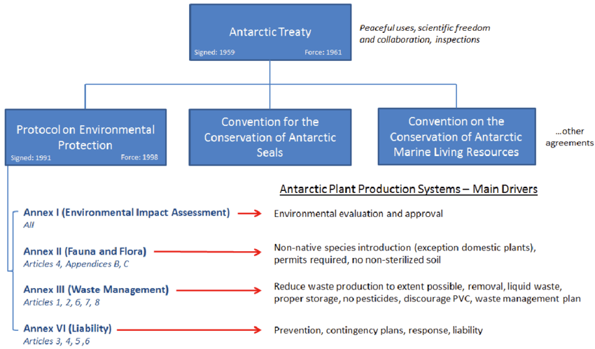
The Antarctic Treaty
- The Antarctic Treaty was signed on December 1, 1959, by 12 nations active during the International Geophysical Year.
- The treaty applies to the area south of 60° South latitude and aims to ensure peaceful uses of the continent.
- Military activities, including establishing military bases or weapons testing, are prohibited.
- The treaty promotes scientific cooperation, exchange of research plans and personnel, and free availability of research results.
- The treaty sets aside potential sovereignty disputes by prohibiting activities that enhance or diminish territorial claims and prohibits new or enlarged claims.
- Nuclear explosions and disposal of radioactive waste are prohibited.
- Parties must give advance notice of their expeditions, and observers can inspect ships, stations, and equipment to ensure treaty compliance.
- Parties meet periodically to discuss measures to further treaty objectives.
- A dispute settlement procedure and a mechanism to modify the treaty are in place.
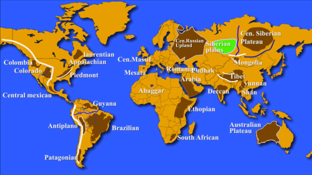
Major Plateaus of the World
- The Plateaus are built over millions of years as pieces of Earth’s crust smash into each other, melt, and gurgle back toward the surface.
- The term Plateau can be defined as the upland which has at least one side of a very steep slope standing well above the neighboring surface and whose upper part is extensively flat.
- The most significant deciding factor of the Plateau is the flatness of its top rather than the height.
List of Major Plateaus of the World
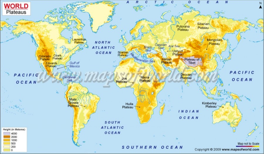
- Colorado Plateau:
- Located in Utah, Arizona, and New Mexico
- Largest plateau in America, covers 337,000km2
- Divided by Colorado River and Grand Canyon
- Example of intermontane plateau with mesas and buttes
- Known for Artesian wells due to positive pressure groundwater
- Columbia Plateau:
- Located in parts of Washington, Oregon, and Idaho
- Surrounded by Cascade Range and Rocky Mountains
- Formed by volcanic eruptions and coated in basalt lava
- Appalachian Plateau:
- Series of rugged dissected plateaus on western side of Appalachian Mountains
- Northwestern part of Appalachian Mountains, stretching from New York to Alabama
- Piedmont Plateau:
- Located in Eastern US between Atlantic coastal plain and Appalachian Mountains
- Consists of three physiographic provinces: Gettysburg-Newark Lowlands, Piedmont Upland, and Piedmont Lowlands
- Laurentian Plateau:
- Canadian Shield or Laurentian Plateau
- Large area of exposed Precambrian igneous and high-grade metamorphic rocks
- Forms ancient geologic core of North American continent
- Central Mexican Plateau:
- Located in northern and central Mexico
- Extends from US border in north to Trans-Mexican Volcanic Belt in south
- Bounded by Sierra Madre Occidental and Sierra Madre Oriental
- Altiplano Plateau:
- Located in west-central South America
- Intermontane plateau between two ranges of Andes Mountain
- Major area of tin reserves
- Capital of Bolivia La Paz and Sucre are situated on this plateau
- Guyana Highland:
- Part of Guyana Shield in northeast South America
- One of the three cratons of the South American Plate
- 1.7 billion-year-old Precambrian geological formation forming a portion of northern coast
- Brazilian Highlands:
- Extensive region covering most of the eastern, southern and central portions of Brazil, approximately half of the country’s land area
- Divided into three plateaus: Atlantic, Southern, and Central
- Atlantic Plateau: extends along the eastern coast of Brazil, was once almost completely covered by the Atlantic Rainforest, one of the richest areas of biodiversity in the world, only 7.3% remains
- Southern Plateau: advances inland in the southern and southern-central portions of the country, sedimentary rocks covered partially by basaltic lava spills that form the fertile ground known as “purple land”, large portions of this region were also covered by the Atlantic Rainforest, while araucaria highland forest and cerrado grasslands took up much of the rest
- Central Plateau: occupies the central portions of Brazil, with sedimentary and crystalline formations, approximately 85% was once covered by cerrado vegetation, of which only a small portion remains intact
- Patagonian Highland:
- Geographical region encompassing the southern end of South America, governed by Argentina and Chile
- Piedmont plateau (Arid Landforms) lying in southern part of Argentina
- Rain shadow desert plateau
- Important region for sheep rearing
- Central Massif:
- Highland region in the middle of southern France, consisting of mountains and plateaus
- Covers about 15% of mainland France
- Famous for Grapes cultivation
- Meseta:
- Basic geographical unit of the Iberian Peninsula
- Consists of a plateau covering a large part of the latter’s interior
- Transylvanian Plateau:
- Plateau in central Romania
- Lies within and takes its name from the historical region of Transylvania, almost entirely surrounded by the Eastern, Southern and Romanian Western branches of the Carpathian Mountains
- Includes the Transylvanian Plain
- Hardangervidda Plateau:
- One of the largest plateaus in Europe located in the Hardanger region of western Norway, about 200 km west of Oslo
- Northwest of the plateau is bordered by one of the largest glaciers of Norway
- Central Russian Upland:
- Upland area of the East European Plain and is an undulating plateau with an average elevation of 230–250 m, its highest peak is measured at 293 m
- Southeastern portion of the upland known as the Kalach Upland
- Tibetan Plateau:
- Highest, largest, and most famous plateau in the world
- Located in South-Central Asia and stretches through the countries of Tibet, China, and India
- 1,000 km north to south and 2,000 km east to west, covers an area of 2,500,000 km2 with a flat valley floor which is about 16,000 feet above sea level
- Formed due to the collision of the Indo-Australian and Eurasian tectonic plates
- The plateau is sufficiently high enough to reverse the Hadley cell convection cycles and to drive the monsoons of India towards the south
- Surrounded by mountains to the south by the Himalayan Range, to the northeast by the Kunlun Range, and to the west by the Karakoram Range.
- Mongolian Plateau:
- Central Asian Plateau, covers 3.2 million square km area
- Bounded by the Greater Hinggan Mountains, Yin Mountains, Altai Mountains, Sayan and Khentii Mountains
- Includes Gobi Desert and dry steppe regions
- Elevation: 1,000-1,500 meters; lowest point in Hulunbuir and highest in Altai
- Central Siberian Plateau:
- Occupies central Siberia between Yenisei and Lena rivers
- Extends over 3.5 million km2, bound by Altai Mountains, Salair Ridge, Kuznetsk Alatau, Eastern and Western Sayan Mountains, North Baikal Highlands and Baikal Mountains
- Surface characterized by wide plateaus and ridges; covers one-third of Siberia
- Deccan Plateau:
- Forms most of southern India, bordered by Western Ghats and Eastern Ghats mountain ranges
- Includes Deccan Traps – the largest volcanic feature on Earth, covering 500,000 square km
- Rich in minerals, such as mica and iron ore in the Chotanagpur region and diamonds, gold, and other metals in the Golconda region
- Yunnan Plateau:
- Located in southwest China, primarily in Yunnan and Guizhou provinces
- Shan Plateau:
- Located in Myanmar, forms part of the Indo-Malayan mountain system
- Crossed by the deep trench of the Salween River in the east and is bordered by the upper course of the Irrawaddy River to the west
- Average elevation: between 2,500 and 4,000 feet (750 and 1,200 m)
- Arabian Plateau:
- Oligocene sub-horizontal regional planation surface, extending throughout the western half of the Arabian Peninsula
- Present elevation of about 1 km required a prominent uplift since the Late Eocene
- Anatolian Plateau:
- Located in modern-day Turkey, lying between Pontiac and Taurus Mountain ranges
- Tigris-Euphrates Rivers flow through the plateau
- Precious wool producing Angora goats are found here
- Ethiopian Plateau:
- Rugged mass of mountains in Ethiopia in northeast Africa
- Forms largest continuous area of its elevation in the continent
- Little of its surface falls below 1,500 m while the summits reach heights of up to 4,550 m
- East African Plateau:
- Large plateau in eastern part of central Africa in Uganda, Kenya, and Tanzania
- Elevation mostly between 1000 and 1500 meters
- Subdivided into a number of zones consisting of mountain ranges, tablelands, and rift valleys
- Table Mountain:
- Prominent landform in Cape Town, South Africa
- Located at the northern end of the Sandstone Mountain Range
- Level plateau measuring 3m from side to side
- Ahaggar Plateau:
- Large plateau in north center of the Sahara, on the Tropic of Cancer, North Africa
- Height above 3,000 feet (900 m), culminating in Mount Tahat (9,573 feet [2,918 m]) in southeastern Algeria
- Katanga Plateau:
- Located in the Democratic Republic of the Congo, famous for copper production
- Other minerals like cobalt, uranium, zinc, silver, gold, and tin are also mined here
- Western Plateau (Australian Shield):
- Australia’s largest drainage division composed predominantly
- Kimberley Plateau:
- Plateau region in northern Western Australia
- Extends from the northwest Indian Ocean coast to Fitzroy River and east to Ord River
- Made of volcanic eruption
- Rich in minerals such as iron, gold, lead, zinc, silver and diamond
- A mining and cattle rearing region
- Atherton Tableland:
- Located in Queensland, Australia
- Covers an area of 32,000km2
- Has an elevation of 500 to 1,280m above sea level
- Antarctic Plateau:
- Located in Central Antarctica
- Cuts across parts of the South Pole and the Amundsen Scott Station
- Covers an area of 1,000km2
- Has its highest elevation of about 3,000m above sea level
- Potohar Plateau:
- Located in the northeastern part of Pakistan
- Bordered by the Jehlum River to the east, the Indus River to the west, the Margalla Hills and the Kala Chitta Range to the north, and the Salt Range to the south
- Encompasses four districts which include Jehlum, Chakwal, Rawalpindi, and Attock
- Mascarene Plateau:
- A plateau located in the Indian Ocean
- Extends between the Seychelles and Mauritius Islands
- Loess Plateau:
- Located in China
- Soil made of fine particles brought by the wind
- Extremely productive for crops grown in this soil along the Yellow River
0 Comments