")
- Asia is the world’s largest continent, covering an area of 44,444,100 sq km.
- It makes up about 30% of Earth’s total land area and 8.7% of the Earth’s total surface area.
- Asia has a population of 4.4 billion, which is 60% of the world’s total population.
- It is a continent of contrasts in relief, temperature, vegetation, and people.
- Asia is located to the east of the Suez Canal, the Ural River, and the Ural Mountains, and south of the Caucasus Mountains and the Caspian and Black Seas.
- It is bounded on the east by the Pacific Ocean, on the south by the Indian Ocean, and on the north by the Arctic Ocean.
- The highest place on earth, Mount Everest, is located in Asia.
- The lowest place on earth, the Dead Sea shore, is also located in Asia.
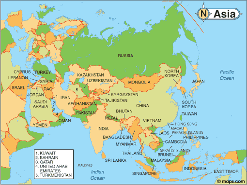
Regional Divisions of Asia
Asia can be divided into six physiographic divisions:
- Central Asia: Kazakhstan, Kyrgyzstan, Tajikistan, Turkmenistan, Uzbekistan
- Eastern Asia: China, Hong Kong, Japan, North Korea, South Korea, Macau, Mongolia, Taiwan
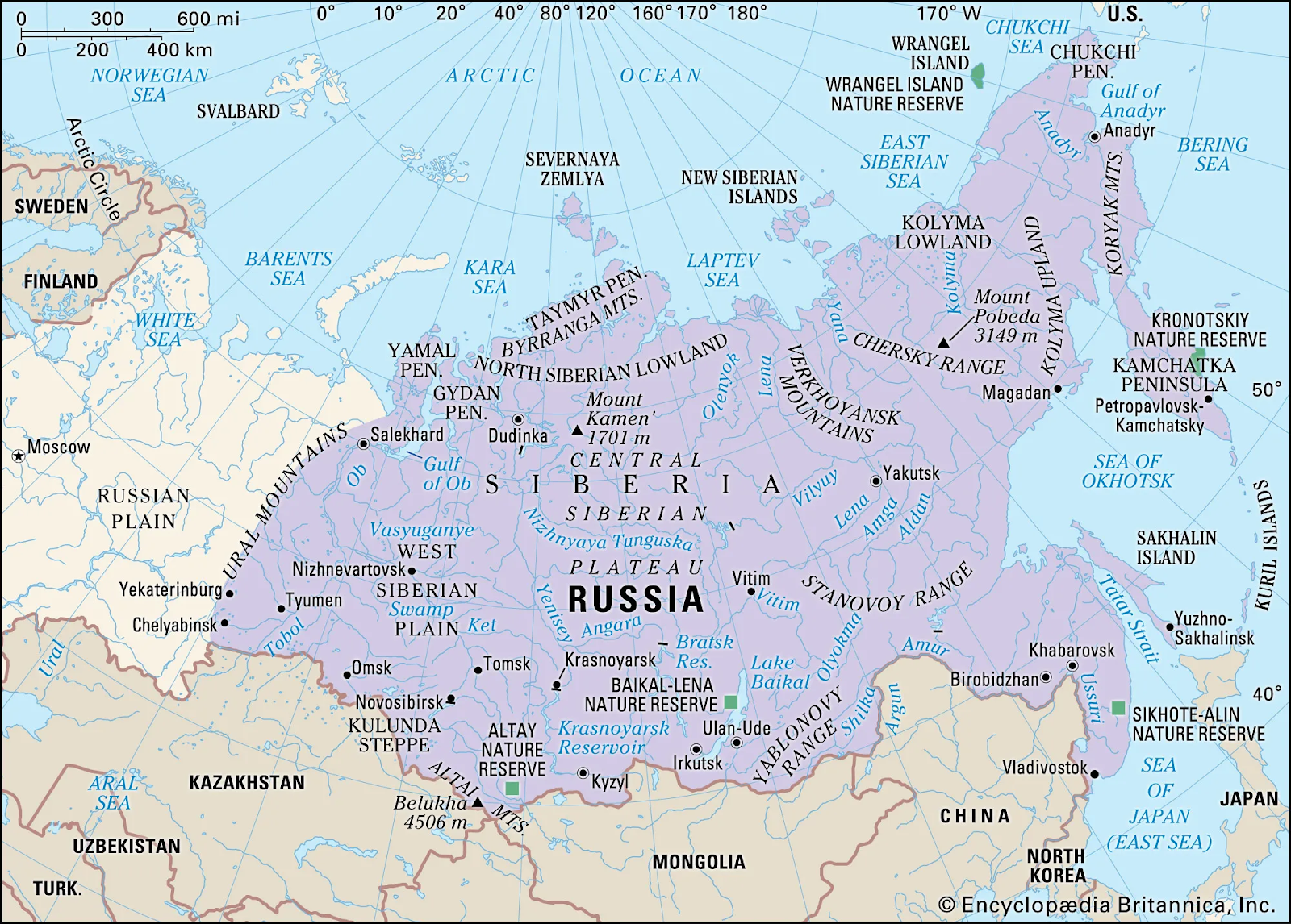
- Northern Asia: Russia
- South-eastern Asia: Brunei, Myanmar, Cambodia, Indonesia, Laos, Malaysia, Philippines, Singapore, Thailand, Timor-Leste, Vietnam.
- Southern Asia: Afghanistan, Bangladesh, Bhutan, India, Maldives, Nepal, Pakistan, Sri Lanka.
- Western Asia: Armenia, Azerbaijana, Bahrain, Cyprus, Georgia, Iran, Iraq, Israel, Jordan, Kuwait, Lebanon, Oman, State of Palestine, Qatar, Saudi Arabia, Syria, Turkey, United Arab Emirates, Yemen.
Major Physical Divisions of Asia
The Northern Lowlands
- The Northern Lowlands consist of several lowland areas on the continent.
- The Great Siberian Plain:
- The Great Siberian Plain is the largest lowland in the world and covers an area of about 1,200,000 square miles.
- The Great Siberian Plain extends between the Ural Mountains in the west and the Lena River in the east.
- The Manchurian Plain:
- The Manchurian Plain is located in the northern part of China and adjoins the Amur River and its tributaries.
- The Manchurian Plain covers an area of about 135,000 square miles.

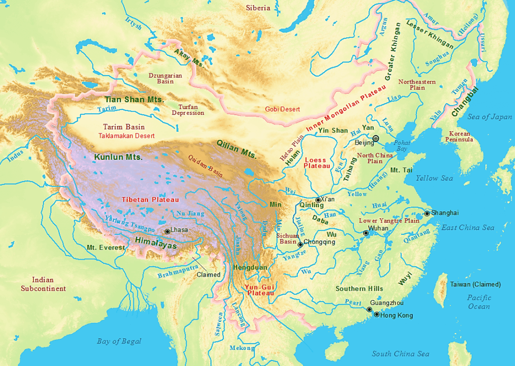
- Great Plains of China:
- It is contributed by two major rivers of China, Hwang Ho and Yangtze river which covers an area of 158,000 square miles approx.
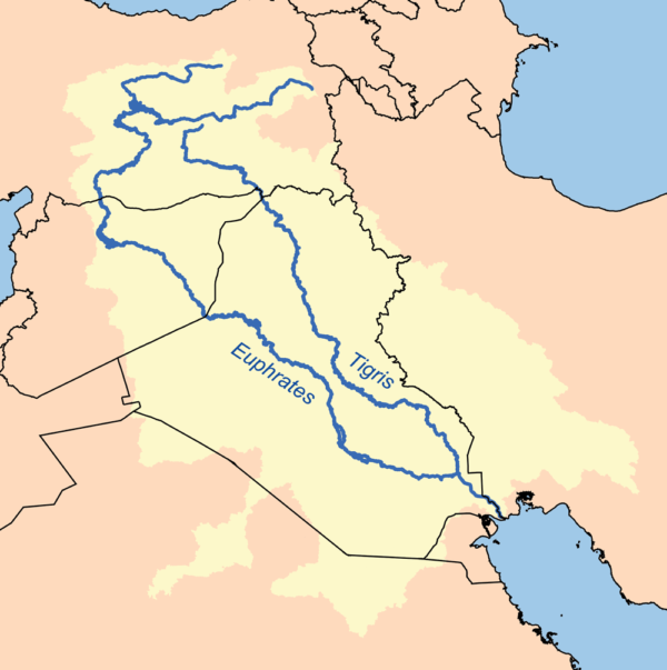
- Tigris-Euphrates plains:
- Ganga plains:

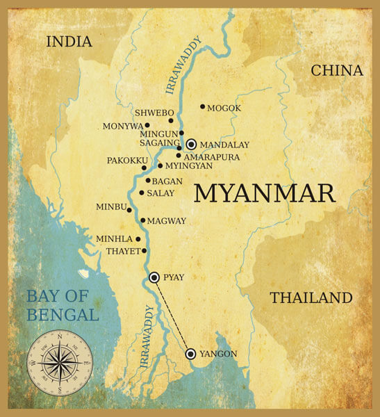
- Irrawaddy plains:
The Central Mountains
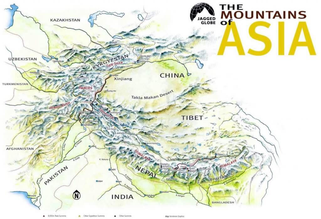
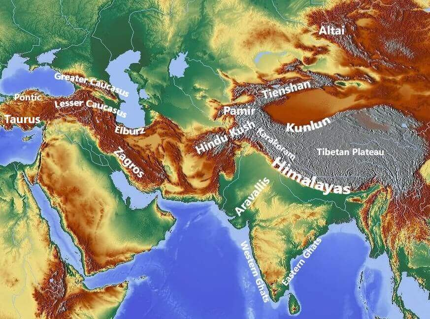
- Pamir and Tian Shan ranges are the prominent and extensive mountain ranges in Central Asia.
- They extend across portions of Afghanistan, China, Kazakhstan, Kyrgyzstan, Tajikistan, and Uzbekistan.
- These mountain ranges are designated as biodiversity hot spots by Conservation International.
- They encompass several habitat types, including montane grasslands and shrublands, temperate coniferous forests, and alpine tundra.
- The Pamir Knot is the junction of five mountain ranges: Sulaiman, Hindu Kush, Kunlun, Karakoram, and Himalayan ranges.
- Mount Everest, the highest peak in the world, is in the Himalayan range.
- The Armenian Knot is connected to the Pamir Knot by the Elburz and Zagros Ranges that originate in the Armenian Knot.
- The Tien Shan and the Altai are other mountain ranges in Asia.
- Peaks of Asia:
- Mount Everest (8848 m), Nepal-Tibet, China border
- K2 (8,61,1 m), Pakistan-China
- Kangchenjunga (8,586 m), Nepal-Sikkim (India).
- Lhotse (8,516 m), Nepal-Tibet, China
- Makalu (8,462 m), Nepal-Tibet, China
- Cho Oyu (8,201 m), Nepal
The Central and Southern Plateaus
Major Plateaus of Asian Continent –
| Plateau | Location | Types |
| Ladakh | Between Karakoram and Himalaya mountain ranges | Intermontane |
| Tibet | Between Kulun and Himalayan Mountain range | Intermontane |
| Yunan | Situated on the southeast of the Tibet Plateau and separated from Szechuan Basin extensive fertile land by the range of Mountains | Piedmont |
| Pamir | Well connected to the range of mountains such as The Himalayas with the Tian Shan, Karakoram, Kunlun, and the Hindu Kush ranges on all sides | Intermontane |
| Armenian | Present in between Caspian and the Black Sea | Piedmont |
| Iranian | Present in between Zagros Mountains, Caspian Sea, Turkmen-Khorasan Mountain Range | Piedmont |
| Mongolian | Surrounded by the Greater Hinggan Mountains in the east, the Yin Mountains to the south, the Altai Mountains to the west, and the Sayan and Khentii mountains to the north | Intermontane |
| Shan | Stretched in the Pegu Yoma and Arkan Yoma in the eastern part of Myanmar, | Intermontane |
| Deccan | Extended in between the Western Ghats in the west and the Eastern Ghats in the east ofIndian Subcontinent, it almost touches the southern tip of India and in north covered by the Satpura and Vindhya Ranges | Intermontane |
| Anatolian | Enclosed between Pontic mountain ranges in the South and Taurus in the southwest | Volcanic |

Peninsulas
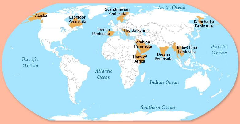
- A peninsula is a mass of land surrounded by water but attached to the mainland.
- The Deccan plateau region is also a peninsula.
- The major peninsulas of Arabia, India, and Malay are in southern Asia.
- The Kamchatka peninsula lies in northeastern Asia.
Deserts
- Asia has some big deserts such as the Gobi, the Takla Makan, the Thar, the Kara-Kum, and the Rub-al-Khali Deserts.
- The Rub’ al Khali desert, considered the world’s largest sand sea, covers an area larger than France across Saudi Arabia, Oman, the United Arab Emirates, and Yemen.

6. (a) Islands of Asia
- Asia also has a cluster of islands, also called an archipelago.
- An archipelago sometimes called an island group or island chain, which is formed close to each other in large clusters.
- Indonesia, Philippines, Japan, Andaman, and Nicobar are some examples of archipelagos.
6. (b) Drainage of Asia
- Asian continent is surrounded by three major oceans from three sides: the Pacific Ocean to the east, the Indian Ocean to the south, and the Arctic Ocean to the northeast.
- The major rivers of eastern Asia drain into the Pacific Ocean, including Menam Mekong, Xi Jiang, Chang Xiang, Huang Ho, and Amur.
- The major rivers that flow into the Indian Ocean are Tigris, Euphrates, the Indus, the Ganga, Brahmaputra, Irrawaddy, and Salween.
- The Arctic Ocean covers the northeast part of Asia and consists of three major rivers: Ob, Yenisey, and Lena.

Seas:
- As the continent is covered by sea from its three sides, It has also characterized by the long stretch of bay and gulf.
- Major seas contributing to Asian Drainage are Andaman Sea, Arabian Sea, Banda Sea, Barents Sea, Bering Sea, Black Sea, Caspian Sea, East Siberian Sea, Java Sea, Kara Sea, Laccadive Sea, Sea of Japan, Sea of Okhotsk. The South China Sea and the Yellow Sea.
- Kara Sea, Laptev Sea, and East Siberian Sea – North of Russia – Arctic Ocean
- Bering Sea – Northerst of Russia – Pacific Ocean
- Sea of Okhotsk – East of Russia – Pacific Ocean
- Sea of Japan – West of Japan – Pacific Ocean
- Yellow Sea – West of Korea – Pacific Ocean
- East China Sea – East of China – Pacific Ocean
- South China Sea – South of China – Pacific Ocean
- Sulu Sea – West of the Philippines Island – Pacific Ocean
- Celebes Sea – North of Celebes Island – Pacific Ocean
- Banda Sea – East of Celebes Island – Pacific Ocean
- Flores Sea – South of Celebes Sea – Pacific Ocean
- Molucca Sea – East of Celebes Island – Pacific Ocean
- Java Sea – North of Java – Pacific Ocean
- Timor Sea – Northwest of Australia – Pacific Ocean
- Arafura Sea – North of Australia – South Pacific Ocean
- Bay of Bengal – East of the Indian Peninsula – Indian Ocean
- Arabian Sea – West of the Indian Peninsula – Indian Ocean
- Red Sea – Separates Asia from Africa – Indian Ocean
Lakes:
- Major lakes of Asia are:
- Lake Baikal, Onega, Ladoga, and Peipus in Russia;
- Lake Akan, Mashu, Biwa, Shikotsu in Japan;
- Qinghai Lake, Lake Khanka in China;
- Dal Lake, Chilka, Vembanada, Pullicat and Sukhna in India;
- Lake Matano and Toba in Indonesia, etc.
- Baikal is the deepest lake in the world. It is in Southern Siberia, Russia.

Freshwater
- Lake Baikal is located in southern Russia and is the deepest lake in the world with a depth of 1,620 meters.
- It contains 20 percent of the world’s unfrozen fresh water and is the largest reservoir on Earth.
- Lake Baikal is also the world’s oldest lake, at 25 million years old.
- The Yangtze is the longest river in Asia and the third-longest in the world, with a length of 6,300 kilometers.
- The Yangtze flows east from the glaciers of the Tibetan Plateau to the river’s mouth on the East China Sea.
- The Tigris and Euphrates Rivers begin in eastern Turkey and flow through Syria and Iraq before joining in the city of Qurna, Iraq, and emptying into the Persian Gulf.
- Mesopotamia, the land between the two rivers, was the center of the earliest civilizations, including Sumer and the Akkadian Empire.
Saltwater
- The Persian Gulf has an area of over 234,000 square kilometers and borders Iran, Oman, United Arab Emirates, Saudi Arabia, Qatar, Bahrain, Kuwait, and Iraq.
- The Sea of Okhotsk covers 1.5 million square kilometers between the Russian mainland and the Kamchatka Peninsula.
- The Bay of Bengal is the largest bay in the world, covering almost 2.2 million square kilometers and bordering Bangladesh, India, Sri Lanka, and Burma.
Straits:
- The important straits in Asia are the Strait of Malacca, Bering Strait, etc.

| Name | Separates | Connects |
| Bering Strait | Asia and North America | East Siberian Sea with Bering Sea |
| La Parouse Strait | Sakhalin Island and Hokkaido Island | Sea of Okhotsk with Sea of Japan |
| Tata Strait | Eastern Russia and Sakhalin | Sea of Okhotsk with Sea of Japan |
| Korea Strait | South Korea and Kyushu (Japan) | Yellow Sea with Sea of Japan |
| Formosa Strait (Taiwan Strait) | Taiwan and China | East China Sea with South China Sea |
| Luzon Strait | Taiwan and Luzon (Philippines) | South China Sea with Pacific Ocean. |
| Makassar Strait | Borneo (Kalimantan) and Celebes Island | Celebes Sea with Java Sea. |
| Sundra Strait | Java and Sumatra | Java Sea with India Ocean |
| Malacca Strait | Malaya Peninsula and Sumatra | Java Sea with Bay of Bengal |
| Strait of Jahore | Singapore and Malaysia | South China Sea with strait ofMalacca |
| Strait of Hormuz | UAE and Iran | Persian Gulf with Gulf of Oman. |
| Strait of Bosporus | Asia and Europe | Black Sea with Sea of Marmara. |
| Strait of Dardanelles | Asia and Europe | Sea of Marmara with MediterraneanSea |

Resources
- Asia’s climate can be divided into three zones: North/Central, Southwest, and Southeast
- North/central Zone–
- The North/Central zone is affected by cold and dry Arctic winds, with permanent frosts that inhibit plant growth
- Hardier grains like barley, buckwheat, millet, oats, and wheat are grown in the central and southern areas, and animal husbandry is also important
- Southwest–
- The Southwest zone is a dry, hot region stretching from the Gobi Desert through Pakistan, Iran, and the Arabian Peninsula
- Grains like barley and corn are principal irrigated crops, while fruit and vegetable crops include dates, figs, apricots, olives, onions, grapes, and cherries
- Southeast–
- The Southeast zone is greatly affected by the summer monsoon season
- Rice is a major food staple and tropical fruits such as mango, papaya, and pineapple are important crops
- Many regions grow wheat where rainfall is less, and India is the world’s largest mango-producing nation
- Mining:
- China, India, Russia, and Indonesia are the continent’s most productive mining economies.
- China is the world’s largest producer of aluminum, gold, tin, and coal.
- India is also a major producer of aluminum and iron ore, along with other minerals such as barite, chromium, and manganese.
- Russia is a major producer of coal, tungsten, diamonds, iron, and steel.
- Indonesia is a major producer of coal, gold, copper, and tin.
- Drilling:
- Countries on the Arabian Peninsula have the world’s largest deposits of oil and natural gas.
- The oil found throughout the Arabian Peninsula and the Middle East is of the highest quality: light sweet crude.
- Light sweet crude oil is used to make gasoline, kerosene, and diesel fuels.
- Saudi Arabia was the world’s largest manufacturer of petroleum liquids in 2010, producing 10.07 million barrels of liquid fuels every day.
- Russia has oil reserves in Siberia and massive natural gas reserves throughout the Arctic.
- Russia and Iran have the world’s largest reserves of natural gas, while the US produces the most.
0 Comments