")
Thousands of islands combine to form the Oceania region mostly covering the Central and South Pacific Ocean.
- The region is dominated by the world’s biggest island and two other major landmasses, micro-continent of Zealandia ( includes New Zealand) and the western half of the island of New Guinea, made up of the nation of Papua New Guinea.
- Oceania also includes three island regions: Melanesia, Micronesia, and Polynesia (including the U.S. state of Hawaii).

- The region stretches from the Strait of Malacca to the coast of the Americas and is divided into two halves by the Tropic of Capricorn.
- Australia is the world’s largest island and smallest continent, covering an area nearly double that of India and Pakistan combined.
- It lies entirely in the Southern Hemisphere and is located between the Indian and Pacific Oceans, with longitude from 114°E to 154°E and latitude from 10°S to 40°S.
- The Tropic of Capricorn almost divides the continent into two parts.
- Asia is the nearest continent to Australia, with Singapore being the nearest point on the mainland of Asia.
- The Indian Ocean is to the west of Australia, Antarctica to the south, New Zealand to the south-east, and Asia to the north-west.
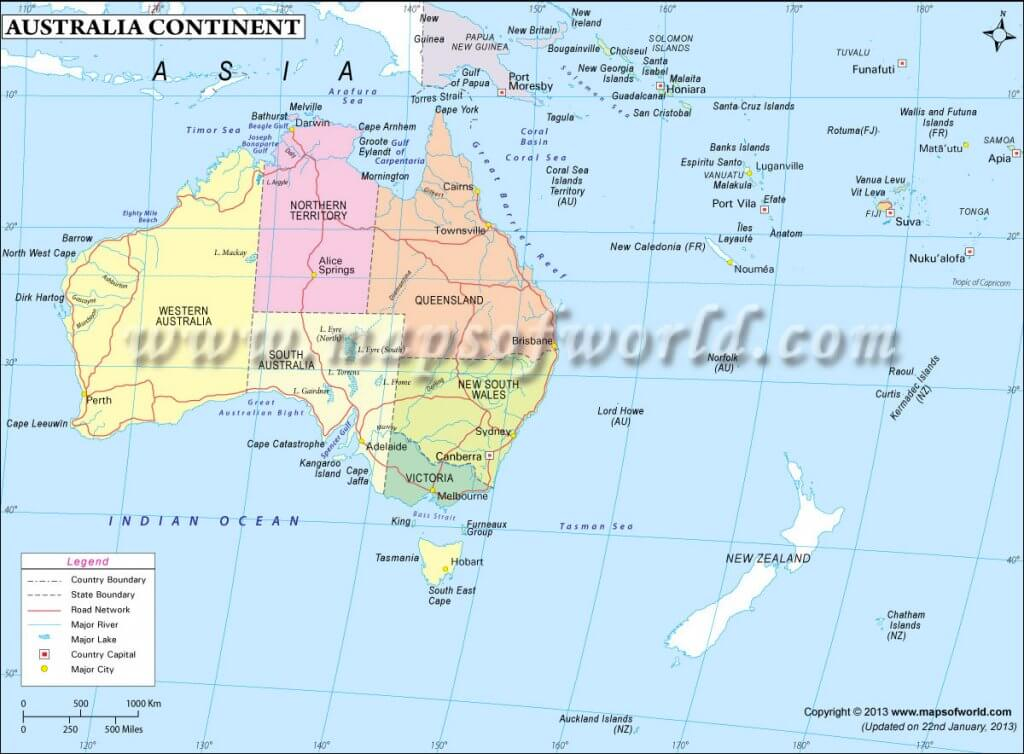
Australia
- Capital: Canberra
- is australia a continent – It is the only continent which is also a country
- It lies between the Indian and the Pacific oceans
- It is surrounded by
- The Timor Sea in the North-West
- The Gulf of Carpentaria in the North,
- Great barrier reef in the north-east &
- Great Australian bight in the south
- To the southeast of the mainland lies the island of Tasmania
- It has 6 states and 2 centrally administered territories:
- Western Australia
- Queensland
- South Australia
- New South Wales
- Victoria
- Tasmania
- Australia is the most leveled and lowest of all the continents.
- There are no high mountains, deep valleys, or large rivers.
- Mount Kosciusko 2,230 meters above sea level, is the highest peak.
- The coastline is very smooth with no inlets except in the south. So there are very few good harbors.
- Australia’s major cities include Sydney, Melbourne, Brisbane, Perth, Adelaide, Cairns, Darwin, and Canberra, the capital.
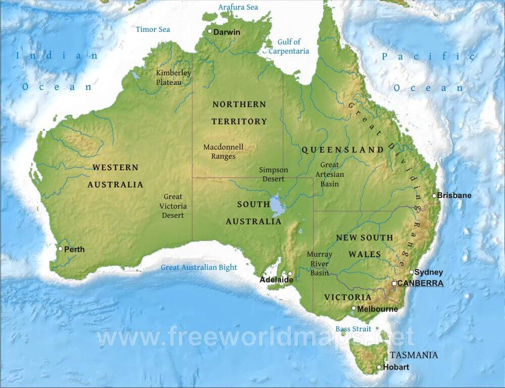
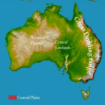
Physical Divisions
- Eastern Highland
- The Western Plateau
- Desert
- The Central Lowland
- The Great Barrier Reef
Eastern Highland
- The Great Dividing Range is a chain of hills and mountains in Australia.
- It is also known as the Eastern Highlands and is Australia’s most substantial mountain range.
- The range stretches more than 3500 km from the northeastern tip of Queen’s land to the Grampians in western Victoria.
- The Great Dividing Range consists of a complex of mountain ranges, plateau, upland areas, and escarpments with an ancient and complex geological history.
- The crest of the range is defined by the watershed or boundary between the drainage basins of rivers which drain directly eastward into the Pacific Ocean, and those rivers which drain into the Murray-Darling River system towards the west.
- In the north, the rivers on the west side of the range drain towards the Gulf of Carpentaria.
The Western Plateau
- The Western Plateau is an eroded plateau characterized by several sinkholes and a network of underground caves that are filled with water.
- It has undergone the process of erosion for a long period.
- The climate is comparatively dry, owing to the cold water current of western Australia.
- This region is home to several deserts, including:
- The Great Victoria Desert
- The Gibson Desert
- The Little Sandy Desert
- The Tanami Desert
- The ranges were originally home to Australian Aboriginal tribes, such as the Kulin.
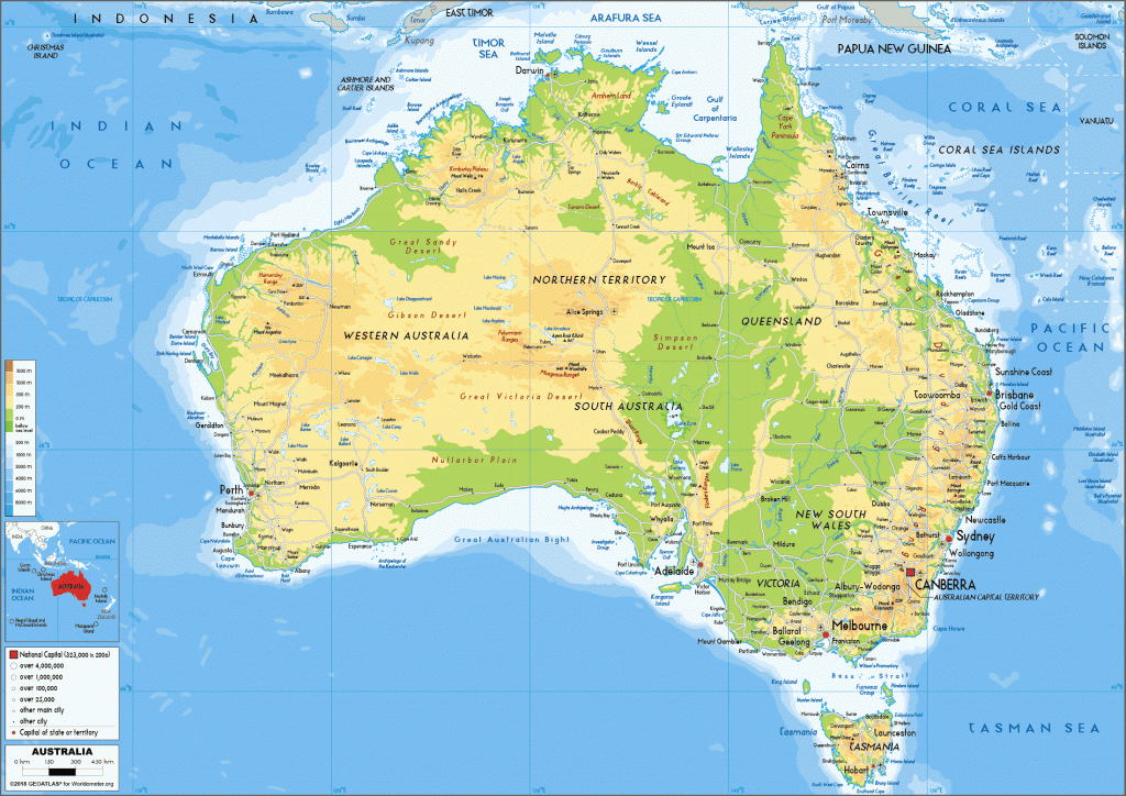
Desert
- Gibson Desert – a central Australian desert
- Great Sandy Desert – a northwestern Australian desert
- Great Victoria Desert – the sixth-largest desert in the world by area, located in south-central Australia.
- Simpson Desert – a central Australian desert
- Little Sandy Desert – a western Australian desert
- Strzelecki Desert – a south-central Australian desert
- Tanami Desert – a northern Australian desert
- Western Desert – a desert located in western Australia, comprising the Gibson, Great Sandy, and Little Sandy deserts.
- Rangipo Desert – a barren light altitude desert on the North Island Volcanic Plateau in New Zealand.
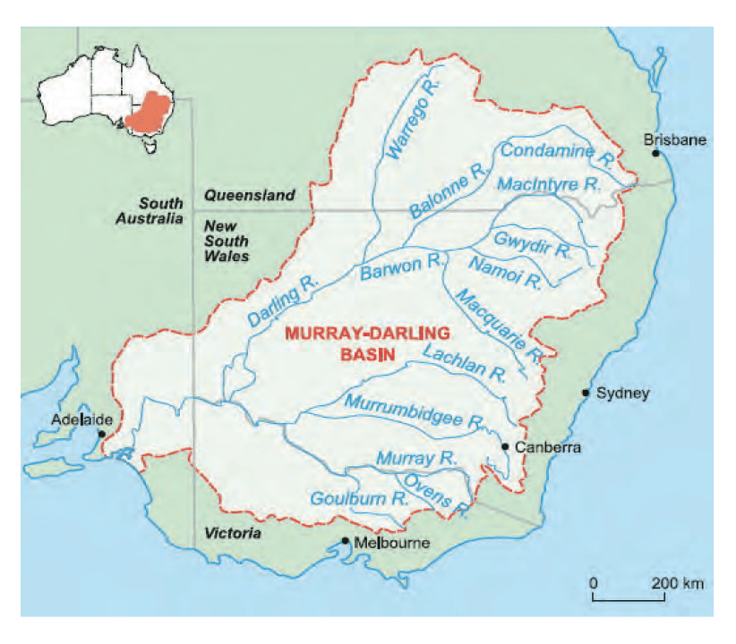
The Central Lowland
- The area between the Eastern Highlands and Western Plateau is a patch of plain or low land.
- It is drained by two rivers: Murray and Darling, which facilitate irrigation for farming and other activities.
- The area is known as the Great Artesian Basin.
- It is covered by a number of underground pressurized wells that bring water to the surface.
- The water from these wells is not suitable for drinking as it is salty.
The Great Barrier Reef
- This is the largest coral reef in the world.
- It lies along the east coast of Queensland, Australia, in the Pacific Ocean.
- It is about 2,000 kilometers long, in some places, it is as close as 16 kilometers to the coast while in other places it is 200 kilometers away.
- It is one of the natural wonders of the world.
- It is formed by the tiny coral polyps.
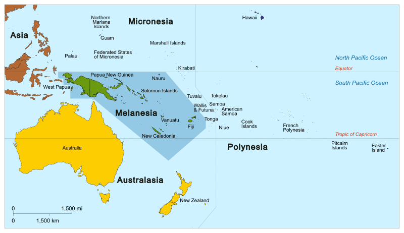
The Islands of Australia & Oceania
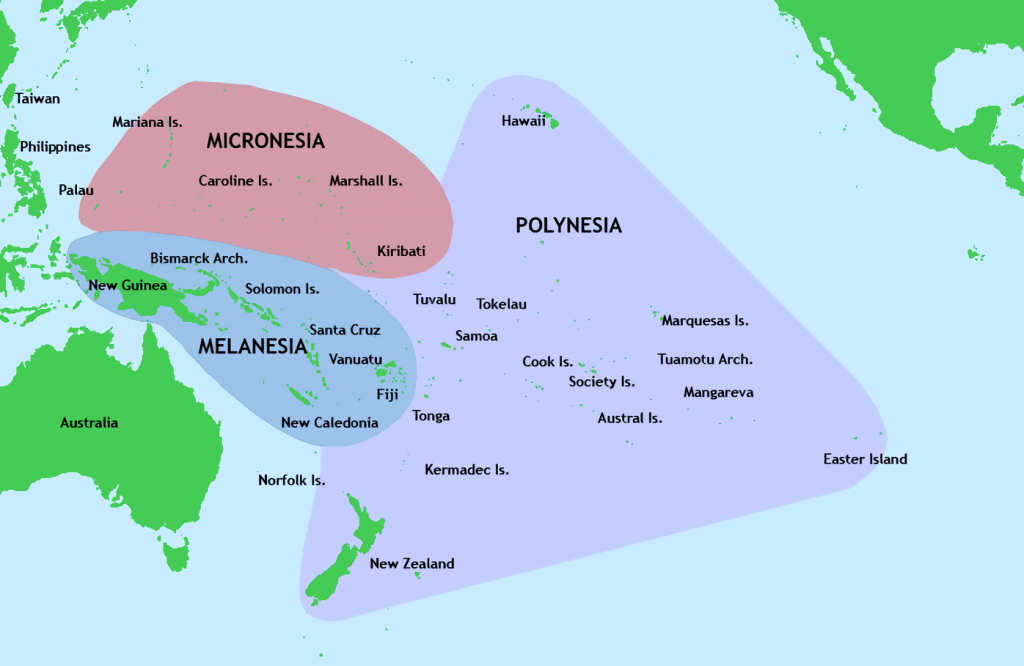
- Oceania is a group of islands surrounding the youngest continent in size
- Oceania is divided into three island groups: Melanesia, Micronesia, and Polynesia
- Melanesia, or Black Islands, is located north and east of Australia and includes islands such as East Timor, Fiji, New Caledonia, Papua New Guinea, Solomon Islands, and Vanuatu
- Micronesia, or Little Islands, includes Guam, Kiribati, Marshall Islands, Federated States of Micronesia, Nauru, Northern Mariana Islands, Palau, and Wake Island
- Polynesia, or Many Lands, extends from the islands of Midway in the north to New Zealand in the south and includes islands such as American Samoa, Cook Islands, French Polynesia, Niue, Pitcairn, Tokelau, Tonga, Tuvalu, Wallis and Futuna Islands
- The islands of Oceania were formed by differential activities of volcanoes
- Low islands of Micronesia were formed by building up coral reefs on the rim of volcanic islands, forming atolls which encircle lagoons with shallow pools of clear water just a few feet above sea level
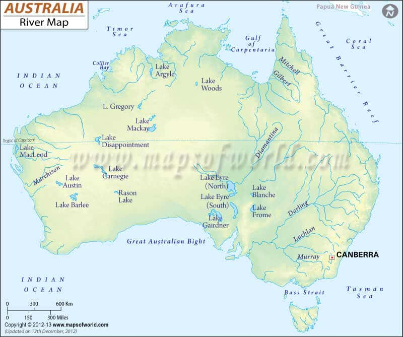
Drainage System
- Australia has low average rainfall and high evaporation rates.
- There is little water left to flow like a river to the sea.
- The continent is mainly drained by two of the largest drainage basins, Murray and Darling.
- An inland lake, Lake Eyre Basin, covers over 1 million square kilometers.
- River Murray starts from the Snowy Mountains of the Great Dividing Range and has tributaries such as the Darling, Murrumbidgee, and Lachlan.
- Dams have been built across these rivers for irrigation and power generation.
- River Swan near Perth is also utilized for irrigation and power generation.
Climatic zones
- There are generally four types of wind that prevail over Australian continent throughout the year which affect the climate of the little continent to a large extent.
- Seasonal change in the Temperate Zones:
- The temperate zones in Australia are found in the coastal hinterlands of New South Wales, much of Victoria, Tasmania, the southeastern corner of South Australia, and the southwest of Western Australia.
- The seasons in the temperate zones are summer (December to February), autumn (March to May), winter (June to August), and spring (September to November).
- The temperate grasslands surround the arid and semiarid desert areas in the center of the continent and extend north of Alice Springs in the Northern Territory.
- The arid and semi-arid desert areas are located in the center of the continent and stretch across a vast area of South Australia and Western Australia.
- Seasonal change in the Tropical Zones:
- There are three climatic zones in tropical Australia: equatorial, tropical, and sub-tropical.
- These areas experience wet and dry seasons, with the wet season lasting from November to March and the dry season from April to October.
- The wet season is also known as the monsoon season and is hotter and more humid, with heavy rainfall and flooding.
- The dry season has lower temperatures and clearer skies, with an average temperature of around 20 degrees Celsius.
Natural Vegetation
- Downs:
- Temperate grassland found in the Murray-Darling basins of South-Eastern part of Australia
- Largely used for pastoral activity
- Profitable cultivation of Mitchel grasses grown on cracking clay soils, basaltic soils, and skeletal soils
- Canterbury grassland: similar grassland found in New Zealand
- Tropical Rainforest regions:
- dense forests with coconut palms and mangroves near shorelines,
- high temperatures throughout the year,
- very little rainfall
- Deciduous forest region:
- wealth of plant life including tall and short trees, shrubs, small plants, and mosses,
- four distinct seasons with warm summers and cold, wet winters,
- trees shed their leaves in autumn
- Savanna:
- very high temperatures all year and rain during the summer season only
- Dry desert and desert scrub region:
- home to eucalyptus and plants that can survive arid conditions like cacti,
- warm to high temperatures with very little rainfall,
- hot summers and cold winters with above-average rainfall
- Varying climate of Australia largely dependent on its size:
- temperature ranges from below zero in the Snowy Mountains in southern Australia to extreme heat in the Kimberley region in the north-west of the continent
- Different climatic zones characterized by distinct phenomena and prominent seasonal changes
- Four seasons (Summer, Autumn, Winter, and Spring) experienced in the Temperate zone, Desert, and the Grassland climatic zones
- Wet and dry seasons in the tropical north of the continent, including Equatorial, Tropical, and sub-tropical zones.
New Zealand
- New Zealand consists of two main islands, the North Island and the South Island, as well as smaller offshore islands.
- The North Island has mountain ranges running through the middle and rolling farmland on both sides.
- The central North Island is dominated by an active volcanic and thermal area called the Volcanic Plateau.
- The South Island has the massive Southern Alps forming its backbone, with farmland to the east and the flat Canterbury Plains.
- New Zealand sits on two tectonic plates, the Pacific and the Australian, which constantly shift and cause geological activity.
Physical features
- Southern Alps:
- Mountains of the South Island, including Mount Cook (3,764 m), the country’s highest peak
- Mount Egmont:
- Extinct volcano in the southwest of the North Island
- Situated to the north of central volcanic plateau of North Island
- Wellington:
- Situated on the southern tip of the North Island
- Country’s capital and southernmost capital city in the world
- An important sea port on the Cook Strait
- Cattle rearing and dairy are the main economic activities around the city
- Auckland:
- Biggest city in the country and largest port on the coast of North Island
- Christchurch:
- Major industrial centre of the South Island
- Taranaki Plain of New Zealand:
- Volcanic plain with a volcanic peak, Mt. Taranaki
- More than 50% of the region has rich pastureland
- Sheep and cattle rearing for dairying and meat production are the main economic activities
- Canterbury Plain of New Zealand:
- The most extensive plains, an example of Piedmont Alluvial plain crossed by rivers cover 12,500 km of the South Island’s east coast
- The chief farming region in New Zealand
- Pastoral farming with predominantly sheep farming for lamb-wool, then cattle rearing for meat, then dairying
0 Comments