Clouds formation
- Clouds form when water vapor in the air condenses into visible water droplets or ice crystals.
- Water vapor is the gas form of water that exists all around us.
- Tiny particles called aerosols, such as salt and dust, are also in the air and constantly bumping into water vapor.
- When air cools, water vapor sticks to aerosols during collisions, causing condensation.
- Water droplets form around aerosol particles and combine with other droplets to form clouds.
- Clouds form when the air is saturated and cannot hold any more water vapor.
- Cloud formation can occur when the amount of water in the air has increased, or when the air is cooled to its dew point.
- Warmer air can hold more water vapor than cooler air.
- Clouds are usually formed through condensation as the air rises and cools.
- The condensation level is the height at which the dew point is reached and clouds form.
What causes clouds to form?
- There are five factors that can lead to air rising and cooling and clouds forming:
- Surface heating – This happens when the ground is heated by the sun which heats the air in contact with it causing it to rise. The rising columns are often called thermals. Surface heating tends to produce cumulus clouds.
- Topography or orographic forcing – The topography, or shape and features of the area, can cause clouds to be formed. When air is forced to rise over a barrier of mountains or hills it cools as it rises. Layered clouds are often produced this way.
- Frontal – Clouds are formed when a mass of warm air rises up over a mass of cold, dense air over large areas along fronts. A ‘front’ is the boundary between warm, moist air and cooler, drier air.
- Convergence – Streams of air flowing from different directions are forced to rise where they flow together, or converge. This can cause cumulus clouds and showery conditions.
- Turbulence – A sudden change in wind speed with height creating turbulent eddies in the air.
The range of ways in which clouds can be formed and the variable nature of the atmosphere results in an enormous variety of shapes, sizes and textures of clouds.
Types Of Clouds
- There are four basic cloud categories observed in our atmosphere –
- Cirrus
- Cumulus
- Stratus
- Nimbus
- The names for clouds are usually are combinations of the following prefixes or suffixes:
- Stratus/strato = flat/layered and smooth
- Cumulus/cumulo = heaped up/puffy, like cauliflower
- Cirrus/cirro = High up/wispy
- Alto = Medium level
- Nimbus/Nimbo = Rain-bearing cloud
- A combination of these four basic types can give rise to the following types of clouds:

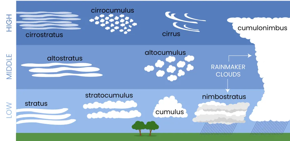
- High Altitude clouds:
- These occur above 20,000 feet.
- They are given the prefix “cirro”.
- They are primarily composed of ice crystals.
- They appear thin, streaky, and white.
- A low sun angle near sunset can create an array of colors on the clouds.
- Cirrus, Cirrostratus, and Cirrocumulus are the cloud types found here.
- Middle Altitude Clouds:
- Bases of clouds appear between 6,500 and 20,000 feet.
- Given the prefix “alto”.
- Composed of liquid water droplets, ice crystals, or a combination of the two, including supercooled droplets.
- The two main types are altostratus and altocumulus.
- Low Altitude Clouds:
- These clouds occur below 6,500 feet and are not given a prefix.
- Their names are derived from “strato” or “cumulo” depending on their characteristics.
- They normally consist of liquid water droplets or even supercooled droplets.
- During cold winter storms, ice crystals and snow can comprise much of these clouds.
- The two main types of low clouds are stratus and cumulus.
- Stratus clouds develop horizontally.
- Cumulus clouds develop vertically.
- Vertical Clouds:
- Clouds that extend from lower to higher altitudes of the atmosphere.
- They form due to thermal convection or frontal lifting.
- Sustained by the convectional current that pushes moisture further upward.
- Example: Cumulonimbus cloud.
- Foggy Clouds:
- Layer of stratus clouds on or near the ground.
- Form close to the ground.
- Sometimes cause poor visibility up to 60 away.
Clouds in Detail
- Cirrus:
- Cirrus clouds are detached clouds in the form of white, delicate filaments, mostly white patches or narrow bands.
- They may have a fibrous (hair-like) and/or silky sheen appearance.
- Cirrus clouds are always composed of ice crystals, and their transparent character depends upon the degree of separation of the crystals.
- They hardly diminish the brightness of the sun’s disk when they cross it, except when they are exceptionally thick.
- Before sunrise and after sunset, cirrus clouds are often colored bright yellow or red.
- Cirrus clouds are lit up long before other clouds and fade out much later; sometime after sunset, they become gray.
- Cirrus near the horizon is often of a yellowish color due to distance and the great thickness of air traversed by the rays of light.
- Cirrostratus:
- Transparent, whitish veil clouds
- Fibrous (hair-like) or smooth appearance
- Extensive sheet of cirrostratus can cover the whole sky
- Distinguished from fog by the halo phenomena produced by the sun or moon
- Cirrocumulus:
- Thin, white patches, sheets, or layers of clouds without shading
- Composed of very small elements in the form of regularly arranged grains or ripples
-
- Altostratus
- Grey or bluish cloud sheets or layers of striated or fibrous clouds that totally or partially covers the sky.
- They are thin enough to regularly reveal the sun as if seen through ground glass.
- Altostratus clouds do not produce a halo phenomenon nor are the shadows of objects on the ground visible.
- Altocumulus
- White and/or grey patch, sheet or layered clouds, generally composed of laminae (plates), rounded masses or rolls.
- They may be partly fibrous or diffuse.
- When the edge or a thin semi-transparent patch of altocumulus passes in front of the sun or moon a corona appears.
- This colored ring has red on the outside and blue inside and occurs within a few degrees of the sun or moon.
- Nimbostratus
- The continuous rain cloud.
- Resulting from thickening Altostratus, This is a dark grey cloud layer diffused by falling rain or snow.
- It is thick enough throughout to blot out the sun.
- The cloud base lowers into the low level of clouds as precipitation continues.
- Stratocumulus
- Grey or whitish patch, sheet, or layered clouds
- Almost always have dark tessellations (honeycomb appearance), rounded masses or rolls
- Non-fibrous, may or may not be merged
- Stratus
- Generally grey cloud layer with a uniform base
- May produce drizzle, ice prisms, or snow grains if thick enough
- Sun’s outline is visible through the cloud
- When a layer of Stratus breaks up and dissipates, blue sky is seen
- Cumulus
- Detached, generally dense clouds with sharp outlines
- Develop vertically in the form of rising mounds, domes, or towers with bulging upper parts
- Sunlit parts of these clouds are mostly brilliant white
- Bases are relatively dark and horizontal
- Cumulonimbus
- Heavy and dense cloud in the form of a mountain or huge tower
- Upper portion is usually smoothed, fibrous or striated
- Nearly always flattened in the shape of an anvil or vast plume
- Under the base of this cloud, there are often low ragged clouds that may or may not merge with the base
- Cumulonimbus clouds also produce hail and tornadoes
Cloud Seeding
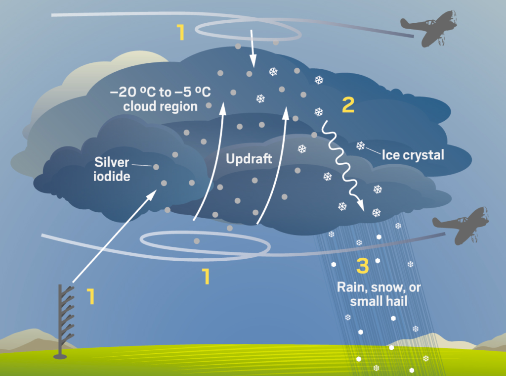
- Cloud seeding is an artificial way to induce moisture in the clouds to cause rainfall.
- Dry ice or silver iodide aerosols are spread into the upper part of clouds for cloud seeding.
- There are three methods of cloud seeding:
- Hygroscopic cloud seeding, which disperses salts through flares or explosives in the lower portions of clouds, causing them to grow in size as water joins with them.
- Static cloud seeding, which involves spreading a chemical like silver iodide into clouds, providing a crystal around which moisture can condense.
- Dynamic cloud seeding, which aims to boost vertical air currents, encouraging more water to pass through the clouds and resulting in more rain.
- Cloud seeding has various applications:
- Agriculture: it can create rain and provide relief to drought-stricken areas.
- Power generation: cloud seeding can augment the production of hydroelectricity.
- Water pollution control: it can help to maintain the minimum summer flow of rivers and dilute the impact of treated wastewater discharges.
- Fog dispersal, hail suppression, and cyclone modification: cloud seeding can be used for weather modification purposes.
- Tackle air pollution: cloud seeding can potentially settle down toxic air pollutants through rain.
- Tourism: cloud seeding can make dry areas more hospitable and enhance tourism.
- Challenges of Cloud Seeding:
- Potential Side-effects: Chemicals used in cloud seeding may be harmful to plants, animals, people, and the environment.
- Abnormal Weather Patterns: Artificially inducing rainfall may change normal climatic patterns, leading to drought in some areas.
- Expensive: Cloud seeding involves delivering chemicals to the sky, which is a costly process.
- Pollution: Seeding agents like silver iodide, dry ice, or salt can fall to the ground and cause pollution. Silver is toxic, and dry ice releases carbon dioxide which contributes to global warming.


0 Comments