- Europe is the second smallest continent in the world.
- Australia is the smallest continent in the world.
- Europe’s area, including the islands around the coast, is about 10 million square kilometers.
- Europe is often called a “peninsula of peninsulas”.
- A peninsula is a piece of land surrounded by water on three sides.
- Europe is roughly three times the size of India.
- Europe is smaller than China.

Location of Europe
- Europe stretches from 35°N to 80°N latitude, mostly in the temperate zone.
- Its longitude ranges from 10°W to 60°E.
- The Prime Meridian passes through Europe, including the UK, France, Spain, and some countries in Africa.
- The Warm Gulf Stream in the north keeps the ports ice-free, even though it stretches into the Arctic Circle.
- Europe has a broad continental shelf on its west, providing good fishing grounds.
- There are sheltered harbors along the indented coastline.
- Europe has the longest coastline in proportion to its size.
Boundaries of Europe
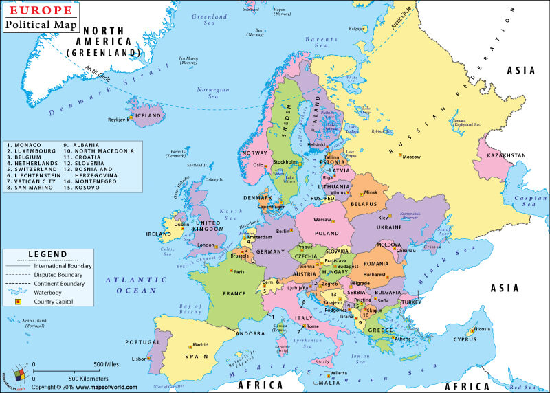
- Europe is separated from Asia by the Ural Mountain, Caspian Sea, Caucasus Mountain, and the Black Sea in the east.
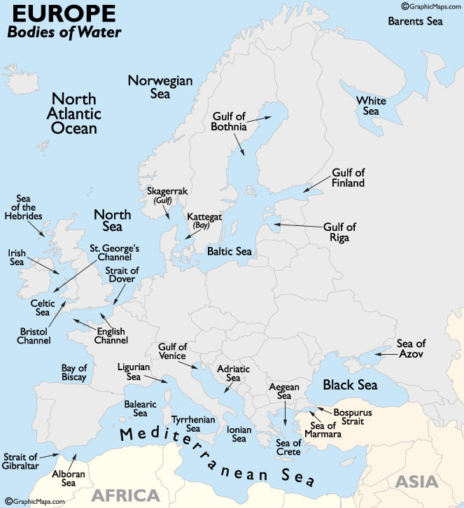
- The Mediterranean Sea is located to the south of Europe, and it has two branches: the Aegean Sea and the Adriatic Sea.
- The Strait of Gibraltar separates Europe from Africa, joining the Mediterranean to the Atlantic Ocean in the west.
- The Bay of Biscay, the English Channel, and the North Sea are parts of the Atlantic Ocean in the west.
- The Baltic Sea with two branches (the Gulf of Bothnia and the Gulf of Finland) is an inlet located in the north.
- The Arctic Ocean to the north has a bay called the White Sea.
- The Balkan Peninsula (Greece) and Italy extend into the Mediterranean Sea in the south-west.
- The Iberian Peninsula is located in the south-west and consists of Spain and Portugal.
- The Scandinavian Peninsula, consisting of Norway and Sweden, is located in the north-west.
europe political map
Physical Divisions of Europe
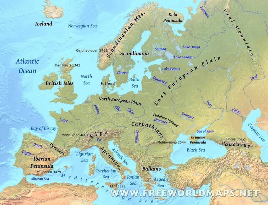
- Western Upland or Northern Highlands define the western edge of Europe, including Norway, Sweden, Denmark, Finland, Iceland, Scotland, Ireland, the Brittany region of France, Spain, and Portugal.
- Glaciations in ancient times formed physical features such as marshlands, lakes, and fjords, including the famous Norwegian Fjords such as Lyse fjord and the Geiranger fjord.
- Fjords are long, deep, narrow bodies of water that reach far inland, often set in a U-shaped valley with steep rock walls on either side.
- North European Plain is an extensive lowland spread along the banks of various mighty rivers such as Rhine, Weser, Elbe, Oder, and Vistula, and covers almost half of Europe.
- Central Uplands or Plateau are a collection of distinctive landscapes of summits, steep slopes, valleys, and depressions that stretch across central Europe, from Belgium in the east to France in the west and from the Czech Republic and south Germany in the south to Switzerland and Austria in the north.
- Alpine Mountain Systems are located in south-central Europe, extending for almost 700 miles in a crescent shape from the coastline of southern France (near Monaco) into Switzerland, then through northern Italy and into Austria, and down through Slovenia, Croatia, Bosnia and Herzegovina, Serbia and Montenegro, then ending in Albania on the rugged coastline of the Adriatic Sea.
- The highest point of the Alpine Mountain Systems is Mont Blanc at 15,771 ft (4,807m).
Mountains:
- The Ural Mountains:
- Mountain range forming natural boundary between Europe and Asia.
- Runs through western Russia from Arctic Ocean to Ural River and Kazakhstan.
- 2,200 km long and 80-120 km broad with many parallel valleys.
- Continuation below the sea on islands such as Vaygach Island and Novaya Zemlya.
- Rich source of minerals and contributes significantly to Russia’s economy.
- Highest peak: Mount Narodnaya (1,894 m).
- The Scandinavian Mountains:
- Located in Scandinavia which includes Norway, Sweden, and Denmark.
- Continues through Finland to the Kola Peninsula in Russia.
- The Old Mountain Blocks:
- Hercynian and Caledonian mountain chains.
- Examples include Meseta of Spain, Central Plateau of France, Brittany Peninsula, Rhine Upland, Block Forest, Vosges, Bohemian Plateau, and Rhodope Mt, etc.
- The Alpine Mountain Ranges:
- Highest peak: Mount Blanc (5,000 m).
- Runs in many branches including the Alps, Carpathians, Balkans, Caucasus, etc.
- Other branches include Apennines (Italy), Atlas (Africa), Sierra Nevada (Spain), Dinaric and Pindus mountain (Yugoslavia and Greece) which enter Asia through Crete island.
- Apennines:
- Range of several sub-ranges running parallel for 1,200 km along Italy.
- Tallest peak is Como Grande (2,912 m).
- Contains pristine forests and montane grasslands protected by national parks.
- Pyrenees:
- Half the length and width of the Alps and separates France from Spain.
- Tallest peak is Pice de Aneto (3,404 m).
- Balkan Mountains:
- Located in the eastern part of the Balkan Peninsula, stretching for 557 km from Bulgaria to the Black Sea.
- Tallest peak is Botev Peak (2,376 m).
- Several protected areas conserve ecosystems and landscapes, and caves are a significant tourist attraction.
- Connected to the history of Bulgaria and its people.
- Caucasus Mountains:
- Form part of the boundary between Europe and Asia.
- Length of approximately 1,200 km, stretching between the Caspian and Black Seas.
- Europe’s highest peak, Mount Elbrus (5,642 m), is located in the Caucasus Mountains.
- All 10 of Europe’s tallest peaks are located in the Caucasus Mountains, particularly in Russia, Georgia, or along the Russia-Georgia border.
Islands of Europe
- Europe is an island rich continent as it is surrounded by a number of seas from all sides.
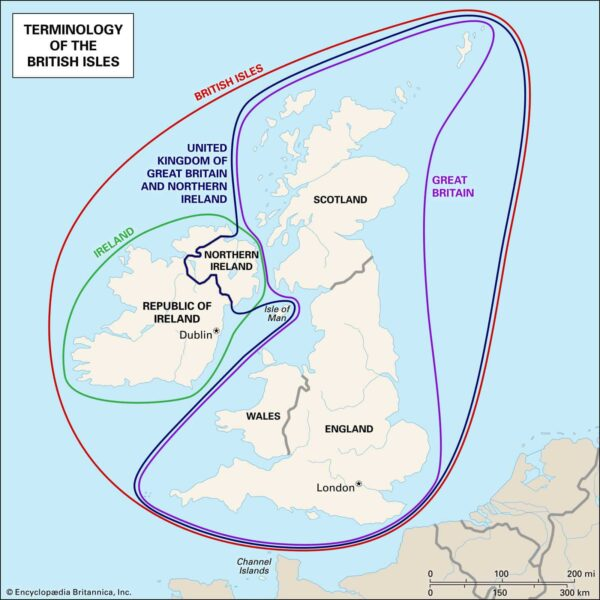
- The British Isles is the largest and most important group of islands consisting of England, Scotland, and Ireland.
- The largest European islands by area are Great Britain, Iceland, Ireland, Severny Island, Spitsbergen, Yuzhny Island, Sicily, Sardinia, Nordaustlandet, and Cyprus.
Peninsula
- Europe’s main peninsulas are the Iberian, Italian, and Balkan, located in southern Europe, and the Scandinavian and Jutland, located in northern Europe.
Drainage Pattern
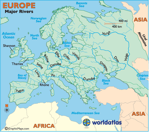
- Europe has perennial rivers fed by melting snow or rain brought by Westerlies, with many having their origin in the Alps.
- Rhone (France) and Ebro (Spain) flow into the Mediterranean Sea, while River Po of Italy flows into the Adriatic Sea.
- The Danube, Dnieper, and Don flow into the Black Sea, while Guadalquivir (Spain), Tagus and Douro (Portugal), Loire and Seine (France), The Rhine Weser and Elbe (Germany) flow into the Atlantic Ocean.
- Many rivers flow into the Baltic Sea and the Thames (UK) flows into the English Channel.
- Rhine and Danube are international rivers passing through many countries.
- The Rhine starts from the Alps in Switzerland, flows northwards through Germany, and enters the sea through Holland. It passes through heavily industrialized regions and is the busiest waterway in Europe.
- The Danube rises from the Alps in Germany and flows through Austria, Hungary, Serbia, and enters the Black Sea in Romania. It is not as important as the Rhine for international trade because of the Black Sea in the interior.
Gulfs and Bays
- Large water bodies adjacent to land are of economic importance for human civilization
- Europe is surrounded by several large water bodies including the Mediterranean Sea, Black Sea, and the North Sea
- There are numerous gulfs, bays, and straits in Europe
- Gulf of Finland is located between Finland and Estonia, extending to Saint Petersburg in Russia
- Gulf of Bothnia is situated in the northernmost part of the Baltic Sea, bordered by Sweden and Finland
- Gulf of Riga is a brackish water body considered a sub-basin of the Baltic Sea
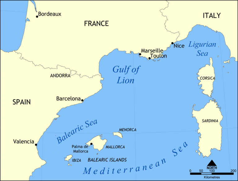
- Gulf of Lions extends from the Pyrenees and covers various lagoons, the Rhone River delta, limestone hills of Marseille. It’s located in the Mediterranean coastline of Languedoc-Roussillon and Provence in France.