")
Glaciers
- A glacier is a huge mass of ice that moves slowly over land.
- The term “glacier” comes from the French word glace (glah-SAY), which means ice.
- Glaciers are often called “rivers of ice.”
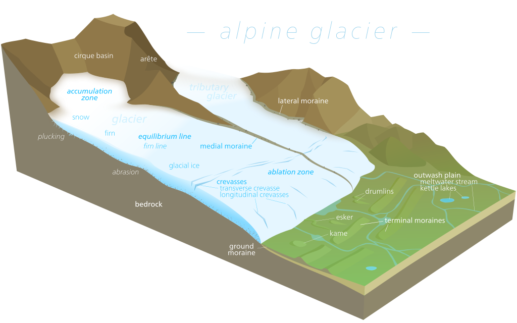
- Glaciers assume the shape of a tongue, broadest at the source & becoming narrower downhill.
- The rate of movement is greatest in the middle where there is little obstruction.
- The sides & bottom are held back by friction due to valley sides & floors.
- If a row of stakes is planted across a glacier in a straight line, they will eventually take a curved shape down the valley, showing that the glacier moves faster at the center than at the sides.
- Glacial landforms can be found in locations that currently have no active glaciers or glaciation processes.
- Glaciers fall into two groups: alpine glaciers and ice sheets.
- Alpine glaciers:
- They form on mountainsides and move downward through valleys.
- Sometimes, alpine glaciers create or deepen valleys by pushing dirt, soil, and other materials out of their way.
- Alpine glaciers are found in high mountains of every continent except Australia.
- Ice sheets:
- They form broad domes and spread out from their centers in all directions.
- Ice sheets cover everything around them with a thick blanket of ice, including valleys, plains, and even entire mountains.
- The largest ice sheets, called continental glaciers, spread over vast areas and cover most of Antarctica and the island of Greenland.
- During the Pleistocene Ice Age, nearly one-third of the Earth’s land was covered by glaciers.
- Today, about one-tenth of the Earth’s land is covered by glacial ice.
The Ice-Age and Ice masses
- An ice age is a long period of reduction in the temperature of Earth’s surface and atmosphere.
- This results in the presence or expansion of continental and polar ice sheets and alpine glaciers.
- Earth’s climate alternates between ice ages and greenhouse periods.
- During greenhouse periods, there are no glaciers on the planet.
- Earth is currently in the Quaternary glaciation.
- Only 2 major ice caps are present in the world – Antarctica & Greenland.
- Ice from the ice cap creeps out in all directions to escape as glaciers.
- When the ice sheets reach down to the sea, they float as ice shelves in polar waters.
- When ice sheets break into individual blocks, these are called icebergs.
- Only 1/9th of the iceberg’s mass is visible above the surface while afloat in the sea.
- Icebergs diminish in size when reaching warm waters & eventually melt, dropping the rock debris that was frozen inside them on the sea bed.
- Permanent snowfield is sustained by heavy snowfall in winters & ineffective snow melting & evaporation in summers.
- Snow that melts during the day is refrozen during the night, forming a hard, granular substance known as neve or firn.
- Owing to gravitational forces, neve of the upland snowfield is drawn towards the valley below.
- This marks the beginning of the flow of glacier, also known as a river of ice.
Glacial Cycle of Erosion
- Youth:
- Inward cutting activity of ice in a cirque.
- Aretes and horns start to emerge.
- Hanging valleys are not prominent.
- Maturity:
- Valley glacier transforms into a trunk glacier.
- Hanging valleys start to emerge.
- Opposite cirques come closer.
- Glacial trough acquires a stepped profile that is regular and graded.
- Old Age:
- Emergence of a ‘U’-shaped valley.
- Outwash plain with features such as eskers, kame terraces, drumlins, kettle holes, etc. is prominent.
- Opposite cirques coalesce.
- Summit heights are greatly reduced.
- Mountain tops become rounded.
Glacial Landforms
- Glaciations generally gives rise to erosional features in the highlands & depositional features on lowlands
- It erodes its valley by two processes viz. plucking & abrasion.
- Plucking:
- Glacier freezes the joints & beds of underlying rocks, tears out individual blocks & drags them away.
- Abrasion:
- Glacier scratches, scrapes, polishes & scours the valley floor with the debris frozen into it.
Glacial Landforms – Erosional

- Glacier Terminus
- The end of a glacier at any given point in time.
- The lowest end of the glacier.
- Corrie, Cirque, or Cwm
- A depression formed by the downslope movement of a glacier from its snow-covered valley head.
- The intensive shattering of the upland slopes also contributes to its formation.
- The depression is horse shoe-shaped and filled with neve or firn.
- Plucking and abrasion deepen the depression further.
- Known as Cirque (in French), cwm (in Wales), and Corrie (in Scotland).
- A rocky ridge exists at the exit of the corrie.
- When the ice eventually melts, water collects behind this barrier known as Corrie Lake or tarn.
- Cols
- Form when two cirque basins on opposite sides of the mountain erode the arête dividing them.
- Create saddles or passes over the mountain.
- Horns
- A single pyramidal peak formed when the summit is eroded by cirque basins on all sides.
- Aretes and Pyramidal Peaks:
- When two corries cut back on opposite sides of the mountain, knife-edged ridges are formed called arêtes.
- When three or more cirques cut back together, recession will form an angular horn or pyramidal peak.
- Bergschrund:
- At the head of a glacier, where it begins to leave the snowfield of a corrie, a deep vertical crack opens up called a Bergschrund or Rimaye.
- This happens in summer when there is no new snow to replace the ice that continues to move out of the corrie.
- In some cases, not one but several such cracks occur which present a major obstacle to climbers.
- Further down, where the glacier negotiates a bend or a precipitous slope, more crevasses or cracks are formed.
- Roche moutonnée:
- A resistant residual rock hummock or mound, striated by ice movement.
- Its upstream or stoss side is smoothened by abrasion & its downward or leeward side is roughened by plucking & is much steeper.
- Plucking may have occurred on the leeward side due to a reduction in pressure of the glacier moving over the stoss slope, providing the opportunity for water to refreeze on the lee side and pluck the rock away.
- Crag and tail:
- A crag and tail is a larger rock mass than a Roche moutonnee.
- It is formed from a section of rock that was more resistant than its surroundings.
- Crag is a mass of hard rock with a steep slope on the upward side, which protects the softer leeward slope from being completely worn down by the oncoming ice.
- It therefore has a gentle tail strewn with the eroded rock debris.
- Nunatak:
- A mountain peak or ridge protruding from an ice field or glacier.
- Also known as glacial islands.
- Paternoster Lakes:
- A series of glacial lakes connected by a single stream or braided stream system.
- Formed in the low depression of a U-shaped valley.
- Created by recessional moraines, or rock dams, formed by the advance and subsequent retreat and melting of ice.
- U shaped Glacial Troughs & Ribbon Lakes:
- Glaciers straighten out protruding spurs of bedrock and deepen the valley floor to form a U-shaped glacial trough.
- After ice melts, deep sections of these troughs may be filled with water to form Ribbon lakes, also known as Trough lakes or Finger Lakes.
- Hanging Valleys:
- Tributary valleys hang above the main valley and plunge down as waterfalls after the main valley erodes much more than the tributary valley.
- Hanging valleys may form a natural head of water for generating hydroelectric power.
- Rock Basins and Rock Steps:
- Glaciers erode bedrock irregularly to create rock basins, which later may be filled with lakes in valley troughs.
- Additional weight of ice in a main valley cuts deeper into the valley floor, forming the deepest point of convergence and creating rock steps.
- A series of rock steps may also form due to different degrees of resistance to glacial erosion of bedrocks.
- Fjord:
- If a glacier flows to the sea, it drops moraine in the sea or when icebergs break off and melt.
- The drowned lower end of the trough in the sea forms a deep, steep-sided inlet called a fjord.
- Fjords are typical of Norway and the Chilean coast, but also found in Greenland and New Zealand.
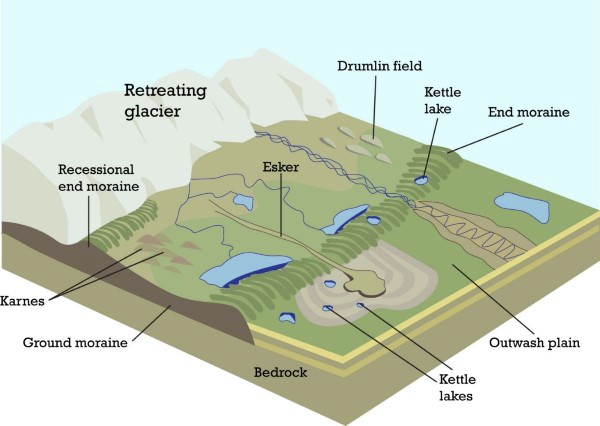
Glacial Landforms – Depositional
- Boulder clay or Glacial till: unsorted glacial deposit comprising boulders, sticky clays & fine rock flour, spread out in sheets, forms gently undulating till or drift plains, degree of fertility depends on composition of depositional materials
- Erratics: boulders of varying sizes transported by ice, stranded in regions of deposition when ice melted, composed of materials different from those of transport regions, useful in tracing source & direction of ice movements, hindrance in farming
- Moraines: pieces of rock shattered by frost action, embedded in glaciers, brought down valley, lateral moraines form on sides of glacier, medial moraines form when two glaciers converge, ground moraine formed by rock fragments dropped when glacier melts, terminal moraine or end moraine formed at snout, may be several succeeding waves forming recessional moraines
- Drumlins: oval-shaped hills composed of glacial drift, formed beneath glacier or ice sheet, aligned in direction of ice flow, low hills up to 1.5 km long and 60 mm tall, steeper onset side & taper off leeward side, commonly referred as a basket of eggs topography, found in clusters in drumlin fields
- Eskers: sinuous ridges composed of glacial material mainly sands & gravel, deposited by meltwater currents in glacial tunnels, generally parallel to direction of glacial flow, sometimes exceed 100 km in length
- Outwash Plains: made up of fluvio glacial deposits washed out from terminal moraines by streams of stagnant ice mass, melt waters sort & redeposit material, often used for specialized kinds of agriculture, such as the potato
- Kettle lake: depressions formed by alternating ridges of deposition, shallow sediment-filled bodies of water formed by retreating glaciers
- Kames: small rounded hillocks of sand & gravel which cover part of plain, often associated with kettles, referred to as kame & kettle topography, also called Hummocks.
0 Comments