Includes Himalayas, Purvanchal, Arakan Yoma (Myanmar), Andaman and Nicobar Islands (considered as islands only).
Youngest and highly unstable landmass.
Prone to tectonic movements.
Indo-Gangetic Plain:
Between Peninsular and Himalayan region.
Most youthful and monotonous region.
Prone to tectonic forces.
Peninsular Plateau:
Includes entire south India, central India, Aravalis, Rajmahal hills, Meghalaya plateau, Kuchchh-Kathiawar region (Gujarat) etc..
Oldest and most stable landmass.
Great Indian desert:
Located in western part of India.
Dry, hot, and sandy stretch of land with very little vegetation.
Coastal Plains:
Eastern and Western Coastal Plains.
Formed due to consolidation of sediments brought by rivers.
Highly stable like Peninsular Plateau.
Indian Islands:
Two major groups – Lakshadweep and Andaman and Nicobar islands.
Lakshadweep are a group of atolls occupied by coral reefs with no significant volcanism or tectonic activity in recent past.
Andaman and Nicobar islands are a continuation of Arakan Yoma with active volcanoes and tectonically active.
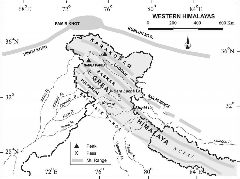
Division of the Himalayas
Shiwaliks or outer Himalayas
Lesser or Middle Himalayas
The Greater Himalayas
The Trans-Himalayas – Tibetan Himalayas.
The Eastern Hills – Purvanchal: A chain of hills in North-East India.
The Himalayan Ranges consist of several parallel or converging ranges
The ranges are separated by deep valleys, creating a highly dissected topography
The southern slopes have steep gradients, and the northern slopes have comparatively gentler slopes
Most of the Himalayan ranges fall in India, Nepal, and Bhutan, with the northern slopes partly situated in Tibet (trans-Himalayas) and the western extremity lying in Pakistan, Afghanistan, and Central Asia
The Himalayas between Tibet and the Ganga Plain is a succession of three parallel ranges
The Shiwalik Range is also known as Outer Himalayas, located in between the Great Plains and Lesser Himalayas
The altitude varies from 600 to 1500 meters, and it runs for a distance of 2,400 km from the Potwar Plateau to the Brahmaputra valley
The southern slopes are steep while the northern slopes are gentle, and the width of the Shiwaliks varies from 50 km in Himachal Pradesh to less than 15 km in Arunachal Pradesh
They are an almost unbroken chain of low hills except for a gap of 80-90 km, which is occupied by the valley of the Tista River and Raidak River
Shiwalik range from North-East India up to Nepal are covered with thick forests but the forest cover decreases towards the west from Nepal
The southern slopes of the Shiwalik range in Punjab and Himachal Pradesh are almost devoid of forest cover. These slopes are highly dissected by seasonal streams called Chos
Valleys are part of synclines, and hills are part of anticlines or antisynclines.
The Shiwaliks are known by different names in different areas
Jammu Region – Jammu Hills
Dafla, Miri, Abor and Mishmi Hills – Arunachal Pradesh
The Dhang Range, Dundwa Range – Uttarakhand
Churia Ghat Hills – Nepal
Shiwalik Hills formed by the accumulation of conglomerates (sand, stone, silt, gravel, debris, etc.).
Conglomerates obstructed the courses of rivers draining from the higher reaches of the Himalayas, forming temporary lakes.
Temporary lakes accumulated more and more conglomerates, which settled at the bottom.
When rivers cut their courses through lakes filled with conglomerate deposits, the lakes were drained away, leaving behind plains called ‘duns’ or ‘doons’ in the west and ‘duars’ in the east.
Dehra Dun in Uttarakhand is the best example.
Kotah, Patli Kothri, Chumbi, Kyarda, Chaukhamba, Udhampur, and Kotli are other important duns.
Middle or the Lesser Himalaya
Location: Between the Shiwaliks in the south and the Greater Himalayas in the north
Runs parallel to both ranges
Also known as Himachal or Lower Himalaya
Width: 60-80 km; Length: 2400 km
Elevations: 3,500 to 4,500 m above sea level
Snow-covered peaks with elevations of more than 5,050 m
Steep, bare southern slopes and forest-covered northern slopes
Middle Himalayas marked by Mussoorie and Nag Tibba ranges in Uttarakhand
Mahabharat Lekh in southern Nepal is a continuation of Mussoorie Range
Lower Himalayas represented by Sapt Kosi, Sikkim, Bhutan, Miri, Abor, and Mishmi hills east of Kosi River
Middle Himalayan ranges more friendly to human contact
Popular Himalayan hill resorts like Shimla, Mussoorie, Ranikhet, Nainital, Almora, and Darjeeling located here.
Important ranges of Lesser Himalayas Region
The Pir Panjal Range – Jammu and Kashmir (They are to the south of Kashmir Valley)
The Dhaola Dhar Range – Himachal Pradesh
The Mussoorie Range and The Nag Tiba Range – Uttarakhand
Mahabharat Lekh – Nepal
Important Valleys:
Kashmir Valley:
Location: Between Pir Panjal and Zaskar Range of the main Himalayas
Synclinal basin with alluvial, lacustrine, fluvial, and glacial deposits
Jehlum River meanders through and cuts a deep gorge in Pir Panjal
Few outlets
Kangra Valley:
Location: Himachal Pradesh
Strike valley
Extends from the foot of the Dhaola Dhar Range to the south of Beas
Kulu Valley:
Location: Upper course of the Ravi
Transverse valley
The Great Himalaya
Name: Trans-Himalayan Range
Also known as Inner Himalaya, Central Himalaya, or Himadri
Average elevation: 6,100 m above sea level
Average width: About 25 km
Composition: Mainly formed of central crystallines (granites and gneisses) overlain by metamorphosed sediments (limestone)
Folds in this range are asymmetrical with a steep south slope and gentle north slope, giving “hogback” topography
Mountain arc convexes to the south like the other two Himalayan ranges
Terminates abruptly at the syntaxial bends: One in Nanga Parbat in northwest and the other in Namcha Barwa in northeast
Boasts tallest peaks in the world, most of which remain under perpetual snow
Sagarmatha (The Goddess of the Sky) – Nepal
Chomlungma (Mother of the World) – China (Tibet)
Passes in the Greater Himalayas:
Jammu and Kashmir – Burzil Pass; Zoji La [La means pass]
Himachal Pradesh – Bara Lacha La; Shipki La
Uttarakhand – Thaga La; Niti Pass; Lipu Lekh
Sikkim – Nathu La; Jelep La
The Trans Himalayas
The Trans-Himalayan Ranges lie immediately north of the Great Himalayan range.
Also called the Tibetan Himalaya because most of it lies in Tibet.
The Zaskar, the Ladakh, the Kailas and the Karakoram are the main ranges.
It stretches for a distance of about 1,000 km in the east-west direction.
The average elevation is 3000 m above mean sea level.
The average width of this region is 40 km at the extremities and about 225 km in the central part.
The Nanga Parbat (8126 m) is an important range which is in The Zaskar Range.
North of the Zaskar Range and running parallel to it is the Ladakh Range.
The Kailas Range (Gangdise in Chinese) in western Tibet is an offshoot of the Ladakh Range. The highest peak is Mount Kailas (6714 m).
River Indus originates from the northern slopes of the Kailas range.
The northernmost range of the Trans-Himalayan Ranges in India is the Great Karakoram Range also known as the Krishnagiri range.
Karakoram Range extends eastwards from the Pamir for about 800 km.
It is a range with lofty peaks [elevation 5,500 m and above].
It is the abode of some of the greatest glaciers of the world outside the polar regions.
Some of the peaks are more than 8,000 meters above sea level.
K2 (8,611 m)[Godwin Austen or Qogir] is the second highest peak in the world and the highest peak in the Indian Union.
The Ladakh Plateau lies to the north-east of the Karakoram Range.
It has been dissected into a number of plains and mountains {Soda Plains, Aksai Chin, Lingzi Tang, Depsang Plains, and Chang Chenmo}.
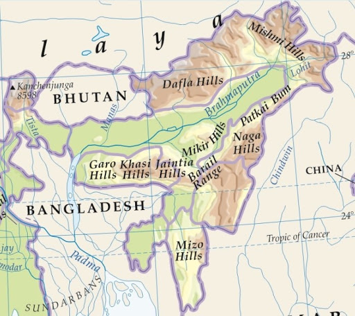
Purvanchal or Eastern Hills
Eastern Hills or The Purvanchals are southward extensions of the Himalayas in the northeast of India.
The Purvanchal hills run along the India-Myanmar Border from Arunachal Pradesh to Mizoram.
They are convex to the west and have a comparatively low elevation.
Patkai Bum hills made up of strong sandstone; elevation varying from 2,000 m to 3,000 m; merges into Naga Hills where Saramati (3,826 m) is the highest peak.
Patkai Bum and Naga Hills form the watershed between India and Myanmar.
South of Naga Hills are the Manipur hills, which are generally less than 2,500 meters in elevation.
The Barail range separates Naga Hills from Manipur Hills.
Further south, the Barail Range swings to the west into Jaintia, Khasi, and Garo hills, which are an eastward continuation of the Indian peninsular block.
Jaintia, Khasi, and Garo hills are separated from the main block by Ganga and Brahmaputra rivers.
South of the Manipur Hills is the Mizo Hills (previously known as the Lushai hills), which have an elevation of less than 1,500 meters.
The highest point in the Mizo Hills is the Blue Mountain (2,157 m) in the south.
")


0 Comments