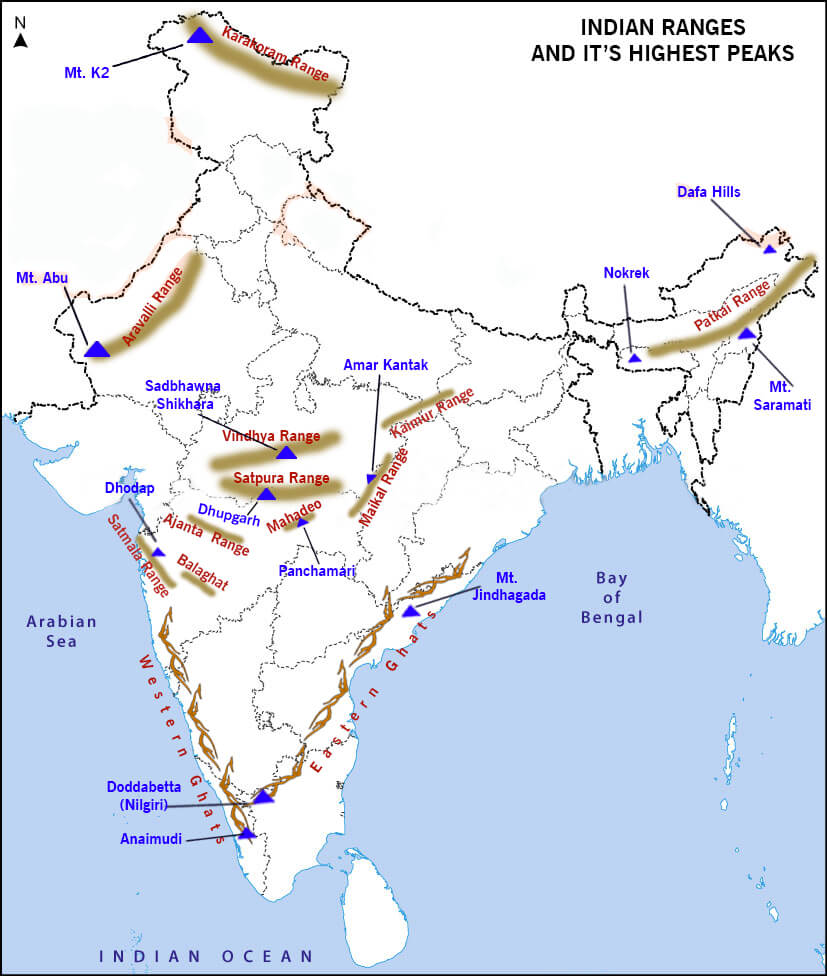
| Maikal Range | Eastern part of the Satpuras range (MP) |
| Kaimur Range | Eastern portion of the Vindhya Range in MP, UP & Bihar, Parallel to river son |
| Mahadeo Range | forms the central part of the Satpura Range, located in MPHighest peak: Dhoopgarh |
| Ajanta Range | Maharashtra, south of river Tapi, sheltering caves of world famous paintings of Gupta period |
| Rajmahal Hills | In Jharkhand made up of lava basaltic rocksPoint of Ganges bifurcation |
| Garo Khasi Jaintia Hills | Continuous mountain range in Meghalaya |
| Mikir Hills | a group of hills located to the south of the Kaziranga National Park (Assam) a part of the Karbi Anglong Plateau |
| Abor Hills | Hills of Arunachal Pradesh, near the border with China, bordered by Mishmi and Miri Hills drained by Dibang River, a tributary of the Brahmaputra |
| Mishmi Hills | in Arunachal Pradesh with its northern & eastern parts touching ChinaSituated at the junction of Northeastern Himalaya and Indo-Burma ranges |
| Patkai Range | Also known as Purvanchal Range, consist of three major hills The Patkai-Bum, the Garo-Khasi-Jaintia, and Lushai Hillssituated on India’s north-eastern border with Burma |
| Koubru Hill | also known as Mount Koupalu is one of the highest mountains in Manipur, and the abode of the god Lainingthou Koubru and the goddess Kounu in Manipuri mythology. |
| Mizo Hills (Lushai Hills) | part of the Patkai range in Mizoram and partially in Tripura |
| Dalma Hills | Located in Jamshedpur, famous for Dalma national park & minerals like iron ore & manganese. |
| Dhanjori Hills | Jharkhand |
| Girnar Hills | Gujrat |
| Baba Budan Giri | Karnataka |
| Harishchandra | At Pune, acts as a water divide bw Godavari & KrishnaHills made up of lava |
| Balaghat range | Bw MP & Maharashtra, famous for manganese deposits |
| Chilpi series | MP |
| Talcher series | Odisha, rich in bituminous coal |
| Champion series | Karnataka, Dharawar period, rich in gold (contains kolar mines) |
| Nilgiri Hills | Referred as Blue mountains, a range of mountains in the westernmost part of Tamil Nadu at the junction of Karnataka and Kerala Hills are separated from the Karnataka plateau to the north by the Moyar River and from the Anaimalai Hills & Palni Hills to the south by the Palghat Gap |
| Palani Hills | The eastward extension of the Western Ghats rangesadjoin the high Anamalai range on the west, and extend east into the plains of Tamil Nadu |
| Anamalai Hills | Also known as Elephant Hill, a range of mountains in the Western Ghats in Tamil Nadu and Kerala with the highest peak Anamudi |
| Cardmom Hills | Part of the southern Western Ghats located in southeast Kerala and southwest Tamil Nadu |
| Pachamalai Hills | also known as the Pachais, The Eastern Ghats in Tamil Nadu |
| Parasnath Hill | Parasnath is a mountain peak in the Parasnath Range. It is located towards the eastern end of the Chota Nagpur Plateau in the Giridih district of Jharkhand. |


0 Comments