


- India is a vast country located in the south-central part of the continent of Asia.
- India is entirely located in the northern hemisphere.
- The mainland extends between latitudes 8°4’N and 37°6’N and longitudes 68°7’E and 97°25’E.
- India is the 7th largest country in the world.
- India is marked off by mountains and the sea, giving it a distinct geographical entity.
- India has a land boundary of about 15,200 km and a coastline of 7,516.6 km.
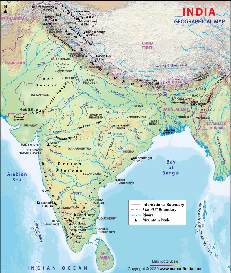
- The country is bounded by young fold mountains in the northwest, north, and northeast.
- The mainland tapers south of about 22° north latitude and extends towards the Indian Ocean.
- The mainland divides the Indian Ocean into two seas, the Arabian Sea on the west and the Bay of Bengal on its east.
- The latitudinal and longitudinal extent of the mainland is about 30°.
- The north-south extent of India appears to be larger than the east-west extent.

- There is a time lag of two hours from Gujarat to Arunachal Pradesh.
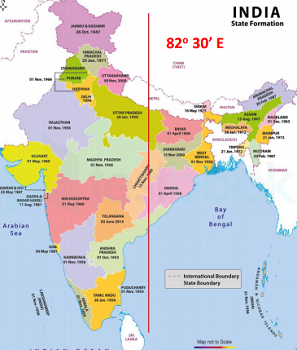
- The Standard Meridian of India (82°30’E) passing through Mirzapur (in Uttar Pradesh) is taken as the standard time for the whole country.
- The latitudinal extent influences the duration of day and night from south to north.
- The Tropic of Cancer passes through eight states in India: Gujarat (Jasdan), Rajasthan (Kalinjarh), Madhya Pradesh (Shajapur), Chhattisgarh (Sonhat), Jharkhand (Lohardaga), West-Bengal (Krishnanagar), Tripura (Udaipur) and Mizoram (Champhai).

Size and Extent –
- East-West Extent of Main Land India (Including Pak occupied Kashmir-POK): 68° 7′ east to 97° 25′ east longitude
- South-North Extent of Main Land India: 8° 4′ north to 37° 6′ north latitude
- Locational Extent: 8° 4′ N to 37° 6′ N latitude and 68° 7′ E to 97° 25′ East longitude.
- The Pygmalion Point or Indira Point is the southernmost point of India, located at 6° 45′ N latitude.
- The north-south extent from Indira Col in Kashmir to Kanniyakumari is 3,214 km.
- The east-west width from the Rann of Kachachh to Arunachal Pradesh is 2,933 km.
- India is the seventh-largest country in the world with an area of 32,87,263 sq km.
- India accounts for about 2.4 percent of the total surface area of the world.
- The Tropic of Cancer passes through the middle of India, dividing it into two latitudinal halves.
- The area to the north of Tropic of Cancer is nearly twice the area which lies to the south of it.
- South of 22° north latitude, India tapers off over 800 km into the Indian Ocean as a peninsula.
Coastline of India
- India is a country that is surrounded by the sea on three of its sides. The coastal plains in India are along the west and east of the country. Extending up to 7516.6 km, the coastal plains in India are of two types: Eastern Coastal Plains of India and Western Coastal Plains of India
- Eastern Coastal Plains of India:
- The eastern coastal plains of India stretch from West Bengal in the north to Tamil Nadu in the south, passing through Andhra Pradesh and Odisha.
- The deltas of the Mahanadi, Krishna, Godavari, and Cauveri rivers are present in the eastern coastal plain.
- The deltas are fertile and productive for agriculture, and the delta of the River Krishna is called the ‘Granary of South India.’
- The Eastern coast is divided into three categories: Utkal coast, Andhra coast, and Coromandel coast.
- The Utkal coast extends between the Chilika Lake and Kolleru Lake and is wider than the western coastal plains.
- The Andhra coast extends between the Kolleru Lake and Pulicat Lake, forming a basin area for the Krishna and the Godavari rivers.
- The Coromandel coast extends between Pulicat Lake and Kanyakumari in Tamil Nadu and receives rainfall during the winter due to the north-east monsoons.
- Chilka lake and Pulicat lake (lagoon) are important geographical features of the east coast.
- Western Coastal Plains of India:
- Western Coastal Plains stretch from Kerala in the south to Gujarat in the north passing through Karnataka, Goa, and Maharashtra.
- The western coastal plains stretch for 1500 km north to south and its width ranges from 10 to 25 km.
- The West Continental Shelf is at its widest off the Bombay coast, rich in oil.
- The western coast is narrower than the eastern coast.
- Kachchh and Kathiawar coast: Kachchh, formerly a gulf is formed by the deposition of silt by the Indus. The area of Kachchh is covered with shallow water during the monsoons and is divided into Great Rann in the north and Little Rann in the east. Whereas, Kathiawar is situated to the south of Kachchh.
- Konkan coast: It extends between Daman in the north to Goa in the south. Rice and cashew are the two important crops of this region.
- Kanada coast: It extends between Marmagaon and Mangalore and is rich in iron deposits.
- Malabar coast: Extending between Mangalore to Kanyakumari, the Malabar coast is relatively broad. This region also consists of lagoons running parallel to the coast in southern Kerala.
- Along the Malabar Coast, there are many beautiful lagoons that make the place a tourist destination.
- Konkan coast = Maharashtra coast and Goa coast; Malabar Coast = Kerala and Karnataka coast.
Standard Time (Time Zone)
- Distance of places on Earth is measured in terms of their distance east or west of the prime meridian (0 longitude) in Greenwich, London, UK.
- The prime meridian is the reference point for Coordinated Universal Time (UTC).
- UTC has 1 hour per 15 degrees longitude.
- For example, 150 degrees west longitude is 10 hours behind UTC or UTC-10.
- In India, 82.5 degrees east longitude has been taken as the reference for Indian Standard Time (IST).
- India is ahead of UTC by 5 hours and 30 minutes.
- The Indian Standard Meridian passes through Uttar Pradesh, Madhya Pradesh, Chhattisgarh, Odisha, and Andhra Pradesh.
India, Tropical or Temperate Country?
- The temperate part (north of Tropic of Cancer) is twice the area of tropical part.
- But India has always been treated as a tropical country for two different reasons – physical and cultural.
- Physical Geographical Reasons:
- The country is separated from the rest of Asia by the Himalayas.
- The climate is dominated by tropical monsoons.
- Temperate air masses are blocked by the Himalayas.
- The entire area south of the Himalayas is essentially tropical in terms of climate.
- Night temperatures in North India may come down to the level of those in temperate lands during winter.
- Clear skies and intense insolation raise day temperatures to a tropical level.
- Cultural Geographical Reasons:
- Settlements, diseases, agricultural and primary economic activities are all tropical in nature.
India’s Frontiers
- India has 15,106.7 Km of land border running through 92 districts in 17 states.
- India has a coastline of 7,516.6 Km, touching 13 states and Union Territories (UTs).
- 6 states – Madhya Pradesh, Chhattisgarh, Jharkhand, Delhi, Haryana, and Telangana – do not have international borders or coastline.
- All other states can be regarded as frontline states from the point of view of border management.
- India’s longest border is with Bangladesh.
- The shortest border is with Afghanistan.
- The length of India’s land borders with neighboring countries is as follows:
- Bangladesh: 4,096.7 km
- China: 3,488 km
- Pakistan: 3,323 km
- Nepal: 1,751 km
- Myanmar: 1,643 km
- Bhutan: 699 km
- Afghanistan: 106km

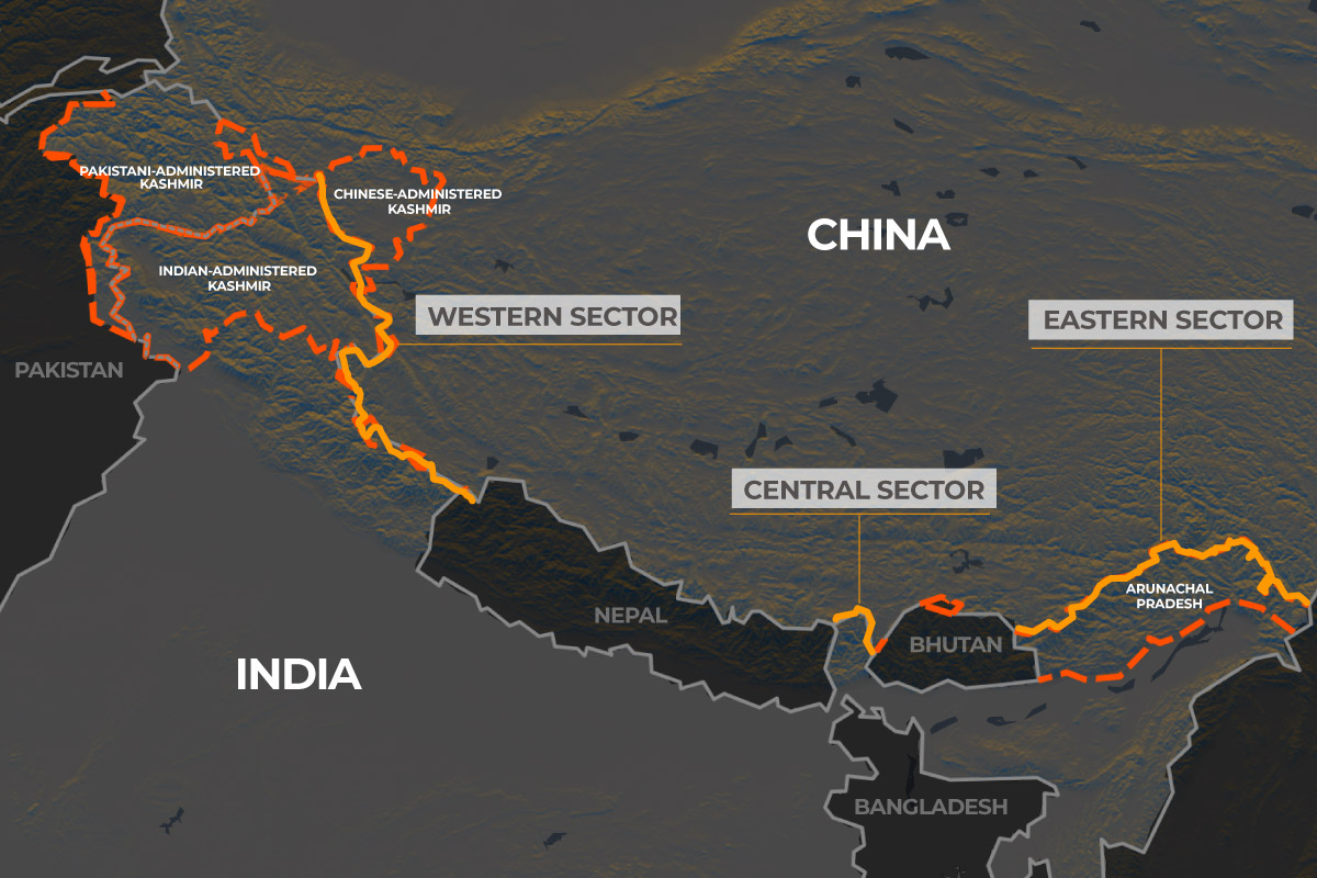
Indo-China Border:
- India’s border with China is the second longest, after its border with Bangladesh.
- Five Indian states – Jammu and Kashmir, Himachal Pradesh, Uttarakhand, Sikkim, and Arunachal Pradesh – touch the Indian boundary with China.
- The Sino-Indian border is generally divided into three sectors:
- The Western sector
- The Middle sector
- The Eastern sector.
- The Western Sector:
- Separates Jammu and Kashmir state of India from the Sinkiang (Xinjiang) province of China.
- The British policy towards the state of Jammu and Kashmir largely determined the western sector boundary.
- China claims several areas in north-east Ladakh, including Aksai Chin district, Changmo valley, Pangong Tso, and Sponggar Tso, as well as a strip of about 5,000 sq km down the entire length of eastern Ladakh.
- China also claims a part of Huza-Gilgit area in North Kashmir (ceded to it in 1963 by Pakistan).
- The Middle Sector:
- Two Indian states of Himachal Pradesh and Uttarakhand touch this border.
- The Eastern Sector:
- The 1,140 km long boundary between India and China runs from the eastern limit of Bhutan to a point near Diphu pass (Talu Pass) at the trijunction of India, Tibet, and Myanmar.
- This line is usually referred to as the Mc Mahon Line after Sir Henry Mc Mahon, then foreign secretary of British India, who negotiated the boundary agreement between Great Britain and Tibet at Shimla accord in 1913-14.
Disputed Territories:
- Western Sector:
- India shares a 2152 km long border with China.
- It is between the Union Territory of Ladakh and Xinjiang Province of China.
- Territorial dispute over Aksai Chin, claimed by India as part of Kashmir and by China as part of Xinjiang.
- Dispute can be traced back to failure of British Empire to demarcate a legal border.
- Johnson’s Line (1865) places Aksai Chin under India’s control while McDonald Line (1893) places it under China’s control.
- India considers Johnson Line as a rightful national border with China, while China considers McDonald Line as the correct border.
- Line of Actual Control (LAC) currently separates Indian areas of Ladakh from Aksai Chin, concurrent with the Chinese Aksai Chin claim line.
- Middle Sector:
- India shares a 625 km long boundary with China.
- The boundary runs along the watershed from Ladakh to Nepal.
- Himachal Pradesh and Uttarakhand touch this border with Tibet (China) in this sector.
- Both sides do not have much disagreement over the border in this area.
- Eastern Sector:
- India shares a 1,140 km long boundary with China.
- The boundary runs from the eastern limit of Bhutan to a point near the Talu Pass at the trijunction of Tibet, India, and Myanmar.
- This boundary line is called McMahon Line.
- China considers the McMahon Line illegal and unacceptable, claiming that Tibetan representatives who signed the 1914 Convention held in Shimla which delineated the McMahon line on the map did not have rights to do so.
The India-Nepal Boundary
- Five states of India, namely Uttarakhand, Uttar Pradesh, Bihar, West Bengal, and Sikkim touch the Nepalese border with India. The border is a porous one with the unrestricted movement of goods and people between Indian and Nepal.
- A major portion of the Indo-Nepalese border runs in the east-west direction almost along the foothill of the Shiwalik Range.
Disputed Territories:
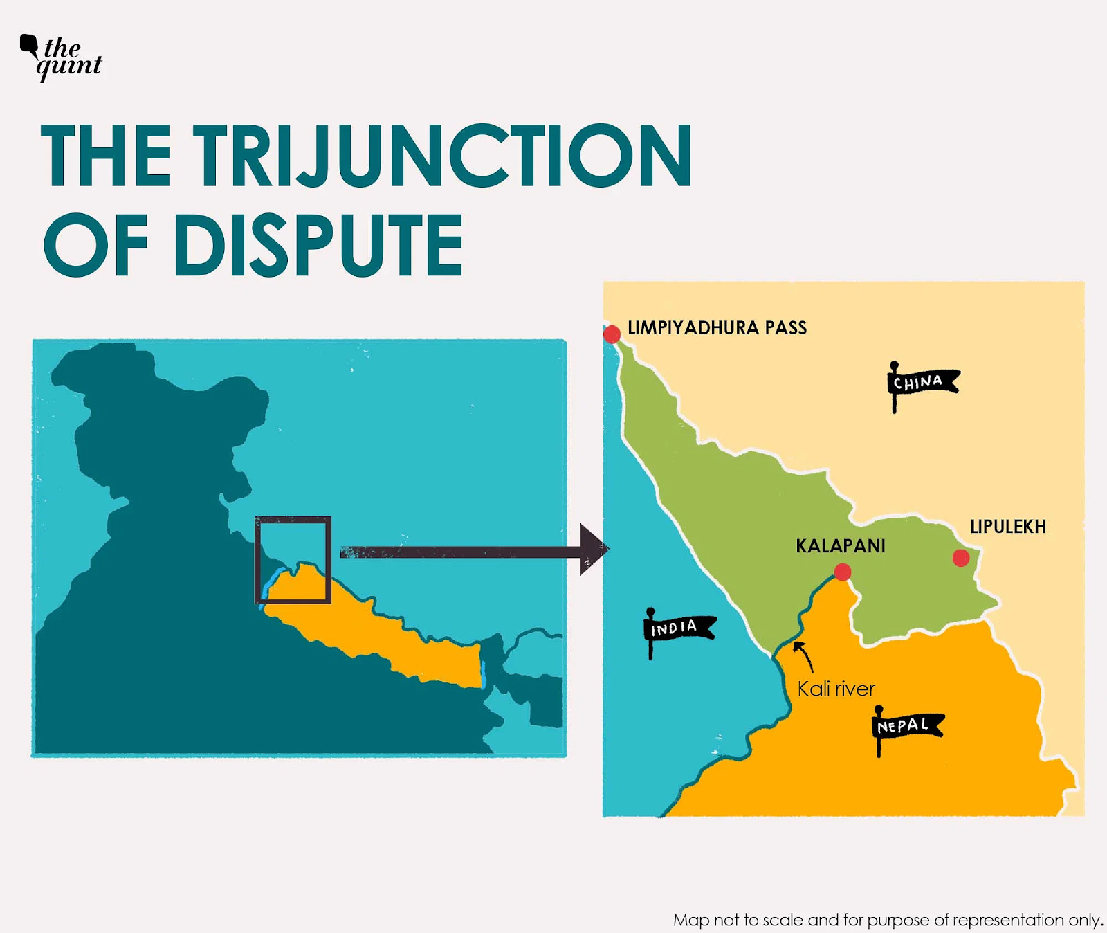
- Kalapani:
- A valley administered by India as part of Pithoragarh district of Uttarakhand.
- Situated on the Kailash Mansarovar route.
- India claims it as part of Uttarakhand, but Nepal says it belongs to its westernmost part.
- The Kali River in the Kalapani region marks the border between India and Nepal.
- Treaty of Sugauli signed by Nepal and British India in 1816 located the Kali River as Nepal’s western boundary with India.
- Boundary disputes arose due to discrepancies in locating the source of the river.
- Susta:
- A disputed area between India (Uttar Pradesh) and Nepal.
- Located on the bank of the Gandak river.
- Disputes arose due to changes in the course of the river.
- According to the Sugauli Treaty, the Gandak river is the international boundary, and the eastern part of the river belongs to India while the western part belongs to Nepal.
- The village of Susta was originally situated west of the river but moved to the east side of the river over time, now on the Indian side.
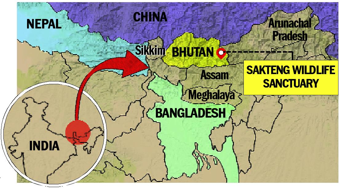
The India-Bhutan Boundary
- Quite peaceful border and there is no boundary dispute between the two countries.
The Indo-Pakistan Boundary
- The Indo-Pakistan boundary is the result of the partition of the country in 1947 under the Radcliffe award of which Sir Cyril Radcliffe was the chairman.
- Jammu and Kashmir, Sir Creek are the major disputed regions.
Disputed Territories:
- Jammu and Kashmir:
- Pakistan is occupying approximately 78,000 sq. km of Indian Territory in Jammu and Kashmir illegally and forcibly.
- Pakistan illegally ceded 5,180 sq. km in Pakistan Occupied Kashmir to China under the so-called Sino-Pakistan Boundary Agreement of 1963.
- Siachen Glacier:
- The Siachen Glacier, located in the eastern Karakorams in the Himalayas just east of the Actual Ground Position Line between India-Pakistan, is under the administration of India since 1984 (Operation Meghdoot).
- The entire Siachen Glacier, with all major passes, is currently under the administration of India.
- Saltoro Ridge:
- The Saltoro Mountains mountain range is claimed as part of Jammu and Kashmir Union Territory by India and as part of Gilgit-Baltistan by Pakistan.
- In 1984, India assumed military control of the main peaks and passes of the Saltoro Ridge range, with Pakistani forces into the glacial valleys just to the west.
- Sir Creek:
- Sir Creek is a 96 km long strip of water disputed between India and Pakistan in the Rann of Kutch marshlands.
- Pakistan claims the line to follow the eastern shore of the estuary while India claims a centerline.
- The International Boundary in the Sir Creek area and International Maritime Boundary line (IMBL) between India and Pakistan have not been demarcated.


The India-Bangladesh Border
- India’s 4,096 km long border with Bangladesh is the longest.
- This boundary has been determined under the Radcliffe Award which divided the erstwhile province of Bengal into two parts.

India-Myanmar Boundary
- This boundary runs roughly along the watershed between the Brahmaputra and Ayeyarwady [Irrawaddy].
- It passes through thickly forested regions, with Mizo Hills, Manipur, and Nagaland on the Indian side and Chin Hills, Naga Hills, and Kachin state on the Myanmar side.
India-Sri Lanka Boundary
- India and Sri Lanka are separated from each other by a narrow and shallow sea called Palk Strait.
- Dhanushkodi on the Tamil Nadu coast in India is only 32 km away from Talaimanar in the Jaffna peninsula in Sri Lanka. These two points are joined by a group of islets forming Adam’s Bridge.
- Though, by and large, peace has reigned where the Indo-Sri Lanka border issue is concerned, there were tensions over the question of who owned Kachchatheevu Island in the Palk Strait. It was given by India to Sri Lanka in 1974.
