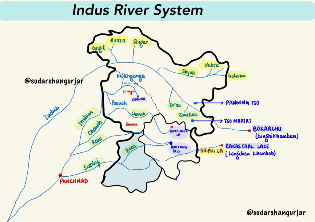
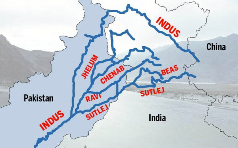
Indus River—The Indus River is one of the world’s largest river basins. It is also known as Sindhu. The river flows through China (Tibet region), India, and Pakistan. In Tibet, it is known as Singi Khambai or Lion’s Mouth.
Himalayan River Systems
- The Himalayan river systems include the Indus, Ganga, and Brahmaputra.
- These rivers existed before the formation of the Himalayas and were flowing into the Tethys Sea.
- They had their source in the Tibetan region.
- The deep gorges of the Indus, Satluj, Brahmaputra, etc. indicate that these rivers are older than the Himalayas.
- They continued to flow throughout the building phase of the Himalayas, with their banks rising steeply and beds going lower due to vertical erosion.
- This vertical downcutting occurred at a rate faster than the rising of the Himalayas, leading to the cutting of deep gorges.
- Many of the Himalayan rivers are typical examples of antecedent drainage.
Indus River System
- Origin of the Indus River – It originates from a glacier near Bokhar Chu in the Tibetan region at an altitude of 4,164 m in the Kailash Mountain range near Mansarovar Lake.
- Entry of the Indus River into India – The river flows northwest and enters the Ladakh region in India from a place called Demchok.
- Path of the Indus River – It flows between the Karakoram and Ladakh ranges, closer to the Ladakh range.
- Turn of Indus River – Near Dungti, the river takes a sharp southwest turn and cuts through the Ladakh range, then takes a northwestern course and continues to flow towards the Leh region of Ladakh between the Ladakh and Zaskar ranges.
- Indus river tributaries – It is joined by the Zaskar River at Leh and near Skardu, it is joined by the Shyok River at an elevation of about 2,700 m.
- Other Himalayan tributaries of the Indus include the Gilgit, Gartang, Dras, Shiger, and Hunza rivers.
- Indus Through Skardu – After flowing through the city of Skardu in the Baltistan region, it enters Pakistan and flows through the northwest frontier province of Khyber Pakhtunkhwa.
- The Kabul River, the main river in eastern Afghanistan and the Khyber Pakhtunkhwa province of Pakistan, empties into the Indus River near Attock, Pakistan.
- The Indus then takes a southwestern course and flows across the Khyber Pakhtunkhwa province and through the plain in the western and southern Punjab province of Pakistan.
- Just above Mithankot, the Indus receives the accumulated waters of the five eastern tributaries – the Jhelum, Chenab, Ravi, Beas, and Satluj – from Panjnad (Panchnad).
- In Sindh Province, the river accumulates a lot of sediments and forms the Indus River Delta before draining into the Arabian Sea near Karachi.
- Blind Dolphin of the Indus- The blind Indus River dolphin, a subspecies of dolphin, is found only in the Indus River.

Left and Right bank tributaries of Indus River
- The Zaskar River, Suru River, Soan River, Jhelum River, Chenab River, Ravi River, Beas river, Satluj river, Panjnad river are its major left-bank tributaries.
- Shyok River, Gilgit river, Hunza river, Swat river, Kunnar river, Kurram river, Gomal River, and Kabul river are its major right-bank tributaries.
Left Bank Tributaries
The following are the left bank tributaries of the Indus River:
- The Zaskar River
- Suru River
- Soan River
- Jhelum River
- Chenab River
- Ravi River
- Beas river
- Satluj river
- Panjnad river
Zanskar River:
- Human settlements are sparse
- Important left bank tributary of the Indus
Jhelum River:
- Tributary of the Chenab River with a total length of 813km
- Rises from a spring at Verinag situated at the foot of the Pir Panjal in the southeastern part of the valley of Kashmir
- The Kishenganga (Neelum) River, the largest tributary of Jhelum, joins it
- The Chenab merges with the Sutlej to form the Panjnad River which joins the Indus River at Mithankot
- Waters allocated to Pakistan under the terms of the Indus Waters Treaty
Chenab River:
- Crossed in J&K by the world’s highest railways bridge named Chenab Bridge.
- Originates from near the Bara Lacha Pass in the Lahul-Spiti part of the Zaskar Range
- Formed by the confluence of the Chandra and Bhaga rivers at Tandi
- Flows through the Jammu region of J&K into the plains of Punjab in Pakistan
- Waters allocated to Pakistan under the terms of the Indus Water Treaty
- Baghliar Dam has been constructed on this river
Sutlej River:
- Known as the Red Rive
- Rises from southern slopes of the Kailash Mountain near Mansarover Lake
- Enters HP at Shipki La and flows through many districts
- Bhakra Nangal Dam, the world’s highest gravity dam, is constructed on this river
- Used for power generation and irrigation
Ravi River:
- Originates in Dhauladhar range of the Himalayas in Chamba district of HP
- Flows northwesterly and is a perennial river of about 720km
- Ranjit Sagar Dam is the major multipurpose project on the river
- Ujh river is a tributary of the Ravi River
- Shahpurkandi Dam project is located downstream from the existing Ranjit Sagar Dam
Beas River:
- Emerges from Rohtang pass in HP
- Merges with the Sutlej River at Hari-Ke-Pattan in Punjab
- Total length is 460km and covers 256km through HP
- Tourist resorts of Manali are situated on the right banks of the River Beas.
Right Bank Tributaries
The following are the Right bank tributaries of the Indus River:
- Shyok River
- Gilgit river
- Hunza river
- Swat river
- Kunnar river
- Kurram river
- Gomal River
- Kabul river
Shyok River:
- Originates from the Karakoram Range and flows through Northern Ladakh region in J&K.
- Length of about 550km.
- Tributary of the Indus River and originates from the Rimo Glacier.
- Widens at the confluence with the Nubra River and marks the southeastern fringe of the Karakoram ranges.
Nubra River:
- Main tributary of the Shyok River and originates from the Nubra Glacier.
- Meanders southeast to join the Shyok River downstream of Shyok Valley at the base of the Ladakh range.
- Nubra Valley, situated at an altitude of 3048m, is formed out of the Nubra River.
- Catchment area is devoid of vegetation and human habitation due to high elevation and lack of rainfall.
Shigar River:
- Small right-bank tributary of the Indus River in the Ladakh region of J&K.
- Rises from the Hispar Glacier and joins Indus at Skardu.
- Descends down a very steep gradient and entire catchment has been influenced by the action of glaciers.
Gilgit River:
- Important right-bank tributary of the Indus River in the Ladakh region of J&K.
- Originates from a glacier near the extreme northwestern boundary of the Himalayas.
- Entire catchment area of the Gilgit River is bleak and desolate.
- Bunji is the main human settlement along the river.
- Ghizar and Hunza are the major right and left bank tributaries respectively.
Hunza River:
- Left-bank tributary of the Gilgit River
- Originates from a glacier north of the Karakoram Range
- Flows southeast and cuts across the Karakoram Range through a spectacular gorge
- Follows a southwesterly direction in its middle course
- Changes course to the southeast in its lower course before merging with the Gilgit

Kishanganga River:
- Originates in Drass, Kargil district of J&K
- Neelam River is its other name
- Flows west and meets Jhelum River in Pakistan
- Famous for ice-cold water and trout fish

Indus Waters Treaty 1960
- The Indus system includes the main Indus River, Jhelum, Chenab, Ravi, Beas, and Sutlej.
- India and Pakistan mainly share the basin, with small shares for China and Afghanistan.
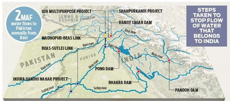
- The 1960 treaty allocated all waters of the Eastern Rivers (Ravi, Sutlej, and Beas) to India for exclusive use.
- Western rivers (Indus, Jhelum, and Chenab) were allocated to Pakistan, except for specified uses by India.
- India has the right to generate hydroelectricity through run-of-the-river projects on Western Rivers.
- India has constructed dams, links, and projects to utilize nearly all of its share of the Eastern Rivers’ waters.
- About 2 million acre-feet of water annually from Ravi is still flowing unutilized to Pakistan below Madhopur.
- India is undertaking projects to utilize its entire share of waters, including the Shahpurkandi Project, the Ujh multipurpose project, and the 2nd Ravi Beas link below Ujh.

0 Comments