Regional Division of Himalayas
- The Himalayas, the abode to the highest peaks on the earth, are an incredible mountain system of Asia and a great wall between the Plateau of Tibet to the north and the alluvial plains of the Indian subcontinent to the south.
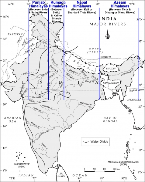
- It is divided longitudinally into 4 divisions from west to east.
- The Kashmir /Punjab/ Himachal Himalayas
- The Kumaun Himalayas
- The Central/ Nepal Himalayas
- The Assam/ Eastern Himalayas
Kashmir /Punjab/ Himachal Himalayas
- Punjab Himalayas are located between Indus gorge and Satluj gorge
- They are 560 km long and 320 km wide
- Zaskar range forms the northern boundary and the Shiwaliks the southern boundary
- Ridge and valley topography with ox-bow lakes like Wular lake, Dal lake, etc.
- Also known as “Vail of Kashmir” and Lacustrine deposits are Karewas
- Karewas have special nutrients for growing saffron, from Pulwama to Pampore
- Receives 100cm rainfall and snow during winters
- Surrounded by slopy mountains of Zaskar and Pir Panjal where alpine grasslands are called Bugyals or Marg, like Sonmarg, Gulmarg
- Also known as “Heaven of the Earth”
- Other ranges are Ratanpir, which joins Pir Panjal
- Only gateway to Kashmir is the Banihal pass which has the Jawahar tunnel (Second Largest in India)
- Several passes in Greater Himalayas connect Kashmir Valley to Ladakh and other regions like Burzil pass, Zozila pass.
Kumaun Himalayas
- Kumaun Himalayas located between Satluj and Kali gorges
- Extends for 320kms
- Major mountain ranges include Nagtiba, Dhaula Dhar, Mussourie, and parts of the Greater Himalayas
- Major peaks include Nandadevi, Kamet, Badrinath, Kedarnath, etc.
- Several glaciers and ice caps, especially in Uttarkhand, giving rise to rivers like Gangotri, Yamunotri, Pindari, etc.
- Receives snowfall during winters and has coniferous forests above 3200m and Deodar forests b/w 1600-3200m.
- This region has two important basins Bhagirathi Plain and Doons. Kulu, Manali, and Kangra are tectonic valleys.
- Hill stations are famous because of their climate and colonial heritage
- This region has 200cm of rainfall and is more vegetated than the Kashmir Himalayas but prone to seismicity and landslides because the rocks are fractured and fragile. Especially the lesser Himalayas are composed of loose rocks like shale, limestone, and conglomerates.
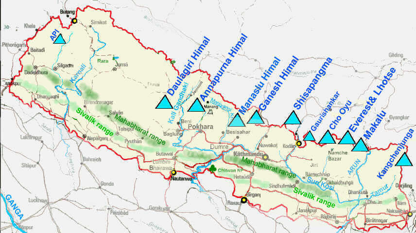
Central/ Nepal Himalayas
- Located between river Kali in the west and river Tista in the east.
- It is 800kms long.
- Some of the world-famous peaks like Mt. Everest(Sagarmatha), Kanchenjunga, Makalu, Annapurna, Gosainthan, and Dhaulagiri are located here.
- These mountains have an orthoclinal plan and have the famous Katmandu valley.
- The Lesser Himalaya is known as Mahabharat Lekh in this region.
- The range is crossed by rivers like Ghaghara, Gandak, Kosi, etc.
- In between the Great and the Lesser Himalayas, there are Kathmandu and Pokhra lacustrine valleys (previously, they were lakes).
- The Shiwalik range comes very close to the lesser Himalaya towards the east and is almost non-existent beyond Narayani (Gandak).
Assam/ Eastern Himalayas
- Located between Tista river in the west and Brahmaputra river in the east
- 750kms long
- Eastern Himalayas occupy Arunachal Pradesh and Bhutan
- Greater Himalayas are identifiable at lesser and Shiwaliks are inseparable in many parts
- Longitudinal valleys are narrow and rainfall is greater than 200cms
- Assam Himalayas show a marked dominance of fluvial erosion due to heavy rainfall
- Ice caps and glaciers were not found because it is close to the tropics
- Densely forested but landslides are common
- Earthquakes are very common as rocks are fractured
- Inhabited by tribes
- The names of ranges are synonymous with tribes
- These mountains are intersected by several ferocious rivers
- This region is very dissected.
Purvanchal
- The Purvanchal Range is considered geologically part of the Himalayas but is structurally different.
- The range lies south of the Brahmaputra valley.
- The Naga hills, which include the highest peak Saramati, are located here.
- The Manipur hills include Loktak Lake, where the only floating national park in the world is located, and the Keibul-Lamjao national park.
- The Mizo hills, previously known as Lushai hills, have the highest part known as Blue Mountain.
- These mountains belong to the Arakan Yoma orogenesis and have loose and fragmented sedimentary rocks like shale, mudstone, sandstone, and quartzite.
- This section is the most fractured part of the Himalayas and has the Naga fault line, making it prone to earthquakes and landslides.
- The region receives rainfall of 150-200 cm and is densely forested, but shifting cultivation poses a threat to the ecology.

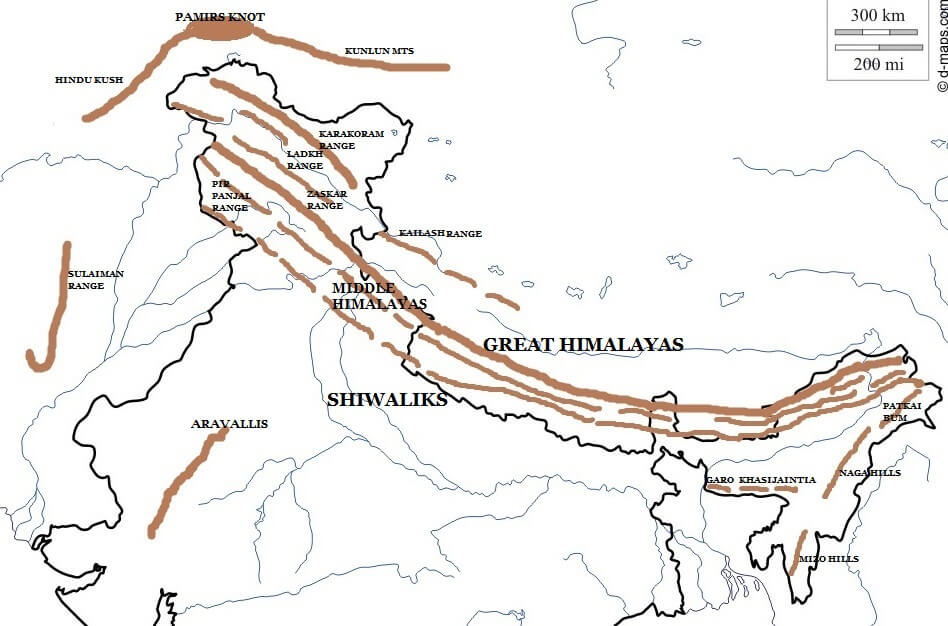
Trans-Himalayan Ranges
- The Trans-Himalayas Mountain Region is located to the north of the Great Himalayas and consists of Karakoram, Ladakh, Zaskar, and Kailash mountain ranges.
- These mountains emerged from Pamir Knot, lifted much before the Himalayas between Jurassic and Cretaceous.
- Karakoram range has the largest and highest peak Godwin Austin or K2 which is the highest peak of India.
- Siachen glacier is the highest battlefield and glacier Baltaro is the largest mountain glacier.
- Ladakh range – The highest point is Rakaposhi, and the extension in Tibet is called Kailash Range from where River Indus originated.
- Zaskar Range – The highest point is Nanga Parbat, and it is separated by Ladakh and Zaskar basin.
- Ladakh Plateau is a cold desert, and in the northwestern part, the Deosai mountains are the end of the Trans-Himalayan region.
- The region generally receives rainfall during winters, mostly barren and cold desert.
- These mountains were lifted much before the Himalayas and are not part of the Himalayas geologically.