")
- Mountain Pass – Mountain pass is a route through a mountain range or over a ridge
- Importance of Mountain Passes in India – Passes have played a key role in trade, war, and human/animal migration
- Role of Passes – They connect different parts of a country and neighboring countries
- Hill Passes – At lower elevations, it may be called a hill pass
- Mountain Passes and River Sources – Mountain passes are often found just above the source of a river
- Drainage Divide by Passes – They constitute a drainage divide
- Structure and Shape – A pass may be short with steep slopes or a long valley
- Surveying the Highest Point of Passes – The highest point may only be identifiable by surveying.
Important Mountain Passes in India
- Zoji La Pass is in the Zaskar range of Jammu & Kashmir and connects Srinagar to Leh
- Banihal Pass is a mountain pass across the Pir Panjal Range and connects Kashmir Valley to the outer Himalayas
- Shipki La Pass is a mountain pass and border post on the India-China border, near the river Sutlej
- Bara-lacha Pass is a high mountain pass in the Zanskar range, connecting Lahaul district in Himachal Pradesh to Leh district in Ladakh
- Rohtang Pass is a high mountain pass on the eastern end of the Pir Panjal Range, connecting Kullu Valley with the Lahaul and Spiti Valleys.
- Mana Pass is a high vehicle-accessible pass, constructed by the Indian military, and is the last point between India and China’s border
- Niti Pass is a pass located in Uttarakhand, India, at an elevation of 5800 meters and connects India with Tibet
- Nathu La Pass is a mountain pass in the Himalayas in the East Sikkim district, connecting Sikkim (India) with Tibet Autonomous Region (China)
- Jelep La or Jelep Pass is a high mountain pass between East Sikkim District, India, and Tibet Autonomous Region, China, on a route that connects Lhasa to India.
Mountain Passes in India (state wise) – Location & Significance
Mountain Passes in Leh & Ladakh

| Khardung La | It is the highest motorable pass in the country. It connects Leh and Siachen glaciers. This pass remains closed during the winter. |
| Thang La / Taglang La | It is located in Ladakh. It is the second-highest motorable mountain pass in India. |
| Aghil Pass | It is situated to the North of Mount Godwin-Austen in the Karakoram. It connects Ladakh with the Xinjiang province of China. It remains closed during the winter season from November to May. |
| Chang-La | It is a high mountain pass in the Greater Himalayas. It connects Ladakh with Tibet. |
| Lanak La | This is located in the Aksai Chin in the Ladakh region. It connects Ladakh and Lhasa. The Chinese authority has built a road to join Xinjiang with Tibet. |
| Imis La | The pass has a difficult geographical terrain and steep slopes. This pass remains closed during the winter season. It connects Ladakh and Tibet. |
| Bara-La/ Bara- Lacha La | It is situated on the National Highway in the state of Jammu and Kashmir. It connects Manali and Leh. |
Mountain Passes in Uttarakhand
| Traill’s Pass | It is located in Uttarakhand. It is situated at the end of the Pindari glacier and connects the Pindari valley to Milam valley. This pass is very steep and rugged. |
| Lipu Lekh: Uttarakhand-Tibet | It is located in Uttarakhand. It connects Uttarakhand with Tibet. This pass is an important border post for trade with China. The pilgrims for Manasarovar travel through this pass. |
| Mana Pass: Uttarakhand-Tibet | It is located in the Greater Himalayas and connects Tibet with Uttarakhand. It remains under snow for six months during winter. |
| Mangsha Dhura Pass: Uttarakhand-Tibet | The pass which connects Uttarakhand-Tibet is known for landslides. The pilgrims for Manasarovar cross this route. It’s located in the Kuthi Valley. |
| Muling La: Uttarakhand-Tibet | It is situated in the north of Gangotri, at an elevation of 5669 m in the Great Himalayas. This seasonal pass that connects Uttarakhand with Tibet remains snow-covered during the winter season. |
| Niti Pass | This pass joins Uttarakhand with Tibet. This also remains snow-covered during the winter season. |
| Debsa Pass: Spiti Valley and Parvati Valley | It joins Spiti Valley and Parvati Valley. It is a high mountain pass in between the Kullu and Spiti of Himachal Pradesh. It is a bypass route of Pin-Parvati Pass. |
| Rohtang Pass: Kullu-Lahul-Spiti | This is located in the state of Himachal Pradesh. It has excellent road transportation. This pass connects Kullu, Spiti and Lahul. |
Mountain Passes in the Northeastern States
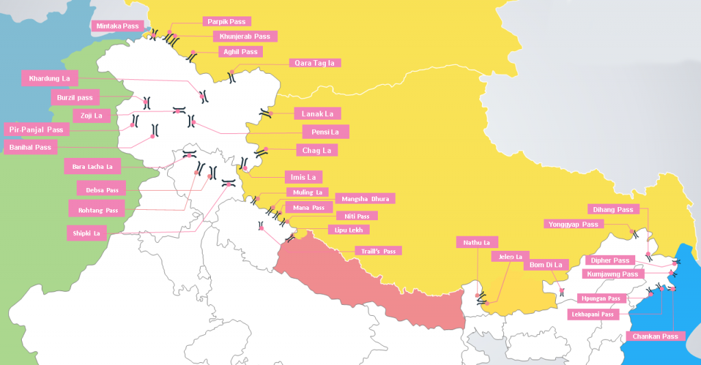
| Nathu La | The Nathu La Pass is located in the Himalayan Range in the state of Sikkim, India at an elevation of 4,310 m. The road passing through Nathu La was once an important auxiliary route making up the ancient Silk Route. It is one of the trading border posts between India and China. |
| Jelep La | This pass passes through the Chumbi valley. It connects Sikkim with Lhasa, the capital of Tibet. |
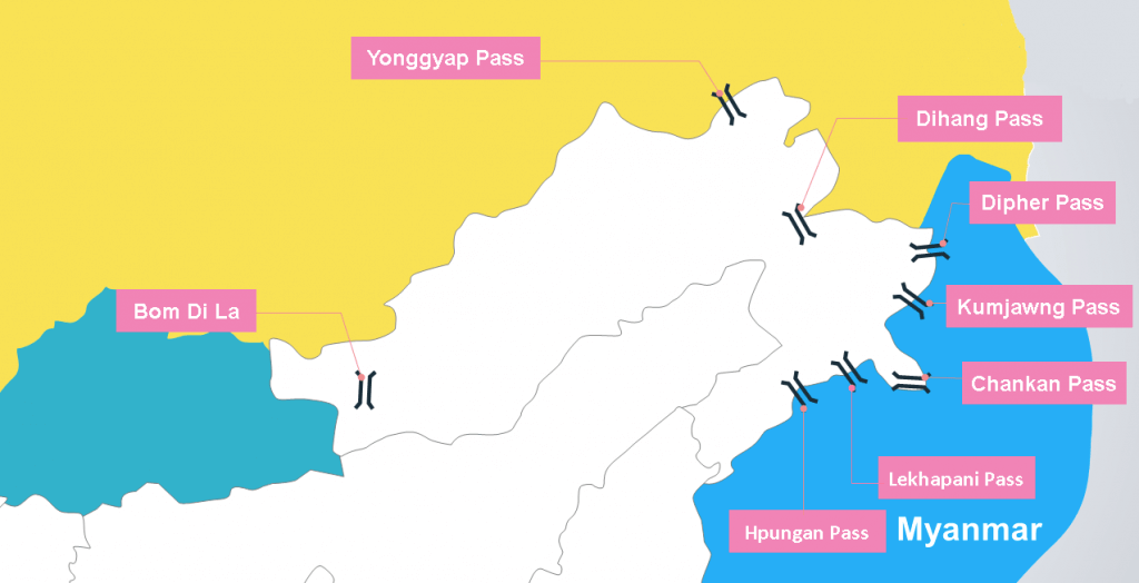
| Bomdi-La: Arunachal Pradesh-Lhasa | The Bomdi-La pass connects Arunachal Pradesh with Lhasa, the capital city of Tibet. It is located in the east of Bhutan. |
| Yonggyap Pass | Yonggyap pass lies at an altitude of 3962 meters on the Indo-China border and joins Arunachal Pradesh with the Tibet region. |
| Dihang pass: Arunachal Pradesh- Mandalay | It is located in the Northeastern states of Arunachal Pradesh. This pass connects Arunachal Pradesh with Myanmar (Mandalay). At an elevation of more than 4000 m, it provides passage. |
| Dihang pass: Arunachal Pradesh- Mandalay | It is located in the Northeastern states of Arunachal Pradesh. This pass connects Arunachal Pradesh with Myanmar (Mandalay). At an elevation of more than 4000 m, it provides passage. |
| Diphu pass: Arunachal Pradesh- Mandalay | Diphu (Dipher) Pass is a mountain pass around the area of the disputed tripoint borders of India, China, and Myanmar. Diphu Pass is also a strategic approach to eastern Arunachal Pradesh. It lies on the McMahon Line. In October 1960 China and Burma demarcated their border to Diphu Pass, which is 5 miles south of the watershed of the mountain ranges. However, this caused a diplomatic row with India, which expected the tri-point to be at the watershed. The dispute has become part of the ongoing border disagreement between China and India regarding Arunachal Pradesh |
| Kumjawng Pass | Kumjawng Pass also lies on the Indo-Myanmar border at an altitude of 2929 and joins Arunachal Pradesh with Myanmar. |
| Pangsau Pass | It is located in the state of Arunachal Pradesh. This pass connects Arunachal Pradesh and Myanmar. Pangsau Pass or Pan Saung Pass, 3,727 feet (1,136 m) in altitude, lies on the crest of the Patkai Hills on the India-Burma (Myanmar) border. The pass offers one of the easiest routes into Burma from the Assam plains. It is named after the closest Burmese village, Pangsau, that lies 2 km beyond the pass to the east. |
| Chaukan Pass | This pass connects Arunachal Pradesh with Myanmar. |
Mountain Passes in Kashmir
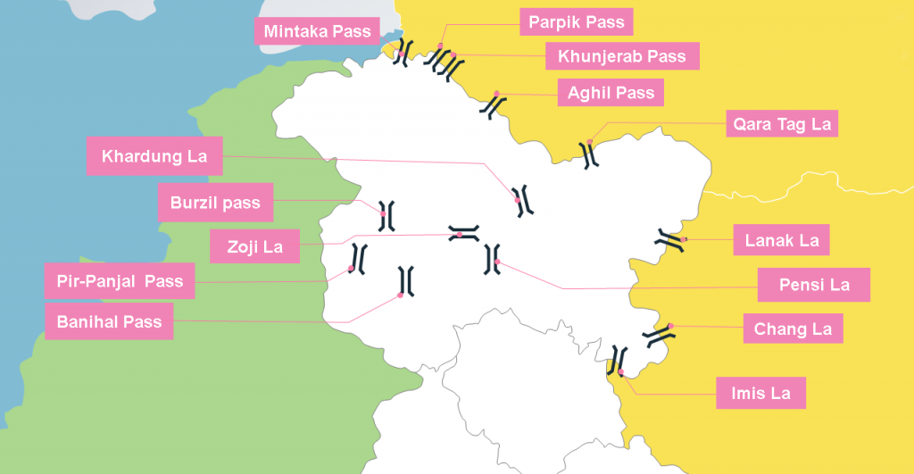
| Banihal Pass (Jawahar Tunnel): Banihal with Qazigund | Banihal pass is a popular pass in Jammu and Kashmir. It is situated in the Pir- Panjal Range. It connects Banihal with Qazigund. |
| Zoji La: Srinagar- Kargil & Leh | It connects Srinagar with Kargil and Leh. Beacon Force of Border Road Organization is responsible for clearing and maintaining the road, especially during the winter. |
| Burzail pass: Srinagar- Kishan Ganga Valley | This pass joins the Astore Valley of Kashmir with the Deosai Plains of Ladakh. |
| Pensi La | The Pensi La connects the Kashmir valley with Kargil. It is situated in the Greater Himalayas. |
| Pir-Panjal Pass | It is a traditional pass from Jammu to Srinagar. This pass was closed after the partition. It provides the shortest roadway access to Kashmir valley from Jammu. |
Mountain Passes in Deccan Plateau (Central & Southern India)
| Shencottah Gap: Madurai-Kottayam | It is located in the Western GhatsIt joins Madurai city in Tamil Nadu with Kottayam district in KeralaThe second-largest gap in the Western Ghats is situated five kilometers from townIt is known as the Shencottah GapRoad-rail lines pass through this gapIt connects Shencottah with Punalur. |
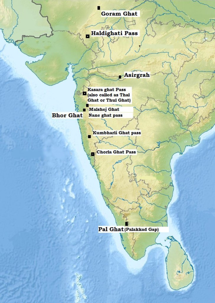
| Bhor Ghat | Bhor Ghat or Bor Ghat or Bhore Ghaut is a mountain passage in Maharashtra, IndiaIt is located between Palasdari and Khandala for railway and between Khopoliand Khandala on the road routeIt is situated on the crest of the Western Ghats at an elevation of 441 meters above sea levelThe ghat was developed by Satavahana to connect ports on the Konkan coast and the Deccan plateauToday, it plays a major part in the Great Indian Peninsula Railway laid from Mumbai to PuneIt has historical significance. |
| Thal Ghat | Thal Ghat is a ghat section in the Western GhatsIt is near the town of Kasara in MaharashtraIt is located on the Mumbai-Nashik routeThal Ghat is one of the four major routes leading into MumbaiThe railway line passing through the ghat is the steepest in IndiaIt has a gradient of 1 in 37. |
| Pal Ghat | The Palakkad Gap is located in the Western Ghats between Tamil Nadu and Kerala in India.It has an elevation of about 140 m.The pass connects Coimbatore in Tamil Nadu with Palakkad in Kerala.The gap is located between the Nilgiri Hills in the north and the Anaimalai Hills in the south.The pass has played a significant role in human migration across India’s southern tip throughout history. |
| Asirgarh Pass (Madhya Pradesh) | Asirgarh Pass is located in the Satpura Range in Madhya Pradesh, IndiaIt has an elevation of about 260 mThe pass connects the Narmada and Tapti ValleysIt is also known as the ‘Key to the Deccan’Asirgarh Fort overlooks the mountain passIt was an important route from northern India to the DeccanDuring the Mughal era, the land from Delhi to Asirgarh was considered as Hindustan and the land beyond was the Deccan. |
| Goram Ghat | Goram Ghat is located in the Aravali Range in RajasthanIt connects Mewar and Marwar regions in RajasthanA railway line passes through Goram GhatThe railway line has 2 tunnels and 172 bridgesThe terrain is densely forested with Dhok forestIt is rich in biodiversity, including medicinal plants and various fauna such as sloth bears, leopards, and wild boars. |
| Haldighati Pass | Haldighati Pass is located in the Aravali Range in Rajasthan, India.The pass is named after the turmeric-colored soil found in the area.It is located about 40 km from Udaipur.The historic ‘Battle of Haldighati’ was fought here in 1576 between Maharana Pratap of Mewar and the Mughals under Emperor Akbar.The Maharana Pratap National Memorial was set up by the Government of India in 1997 on the site, which includes a bronze statue of Maharana Pratap’s horse Chetak. |
| Jabalpur Gap | Jabalpur (formerly Jubbulpore) is a tier 2 city in the state of Madhya Pradesh. |
| Khandwa Gap | Khandwa is a city and a nagar nigam in the Nimar region of Madhya Pradesh. |
| Burhanpur Gap | Burhanpur is a district in Madhya Pradesh.The district is bounded by the river Tapti and Satpura range.There is a gap located to the north of the Tapti river and the Satpura range.This gap is known as the Burhanpur gap. |
| Amba Ghat Pass | It has picturesque mountain-scapes and a pleasant climate. This region is famous for paragliding sport.State: MaharashtraLocation: Sahyadri Mountains of Western Ghats |
| Chorla Ghat Pass | This region is famous for the rare species of wolf snake (Lycodon striatus).State: Goa, Karnataka, and Maharashtra.Location: Sahyadri mountain range of Western Ghats (On the intersection of the borders of Goa, Karnataka, and Maharashtra) |
| Malshej Ghat Pass | This region is famous for wide variety of birds such as quails, rails, crakes, flamingos, and cuckoos.State: Maharashtra, IndiaLocation: Sahyadri Range of Western Ghats (Lofty rugged hills of the Western Ghats) |
| Naneghat Pass | It is also called as Nanaghat or Nana Ghat. It was a part of an ancient trading route. The name nane means “coin” and ghat means “pass”. The name is given because this path was used as a tollbooth to collect tolls from traders crossing the hills.State: Maharashtra, IndiaLocation: Sahyadri Range of Western GhatsBetween/Separating: It connects Pune district to Junnar City. |
| Tamhini Ghat | This region is famous for sprawling green Ghats, misty roads, and cascading waterfalls.State: Maharashtra, IndiaLocation: Sahyadri Range of Western GhatsBetween/Separating: It connects the talukas of Mulshi and Tamhini in the Pune district. |
| Amboli Ghat Pass | This region is for wildlife, dense hilly forests, Hiranyakeshi temple, and a number of waterfalls.State: Maharashtra, IndiaLocation: Sahyadri Range of Western GhatsBetween/Separating: It connects Sawantwadi of Maharashtra to Belgaum of Karnataka. |
| Kumbharli Ghat Pass | It connects the coastal Ratnagiri district in the Konkan region of Maharashtra with the Satara District in the Desh region.State: Maharashtra, IndiaLocation: Western GhatsBetween/Separating: It connects the coastal Ratnagiri district in the Konkan region of Maharashtra with the Satara District in the Desh region. |
Khyber Pass
- The Khyber Pass is a mountain pass in the Khyber Pakhtunkhwa province of Pakistan.
- It is located on the border with Afghanistan (Nangarhar Province).
- The pass connects the town of Landi Kotal to the Valley of Peshawar at Jamrud by traversing part of the Spin Ghar mountains.
- It has long had substantial cultural, economic, and geopolitical significance for Eurasian trade.
- It has been an important trade route between Central Asia and the Indian subcontinent throughout history.
- It has been a vital strategic military choke point for various states that came to control it.
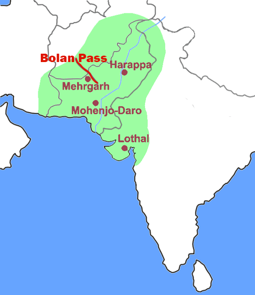
Bolan Pass
- The Bolān Pass is a mountain pass in the Balochistan province of western Pakistan.
- It is located 120 km away from the Afghanistan border.
- The pass stretches for 89 km from Rindli in the south to Darwāza near Kolpur in the north.
- It consists of narrow gorges and stretches in the Bolan river valley.
- The pass is situated southeast of Quetta.
- The archaeological site of Mehrgarh is located near the Bolan Pass.
- The Toba Kakar Mountains, a southern offshoot of the Himalayas, are located in the Balochistan region of Pakistan.
List of Major Mountain Passes in India
| Name | State | Height | Between/ Separating |
| Asirgarh | Madhya Pradesh | ||
| Auden’s Col | Uttarakhand | 17,552 | |
| Banihal Pass | Jammu and Kashmir (Jammu, Kashmir) | 9,291 | Jammu & Kashmir |
| Bara-lacha-la | Himachal Pradesh | 16,400 | |
| Bomdila | Arunachal Pradesh | ||
| Changla Pass | Jammu and Kashmir (Ladakh) | 17,585 | Leh & Changthang |
| Chanshal Pass | Himachal Pradesh | 14,830 | |
| Dehra Compass | Jammu and Kashmir (Ladakh) | ||
| Debsa Pass | Himachal Pradesh | 17,520 | |
| Diphu Pass | Arunachal Pradesh | 4,587 | |
| Dongkhala | Sikkim | 12,000 | |
| Dhumdhar Kandi Pass | Uttarakhand | ||
| Fotu La | Jammu and Kashmir (Ladakh) | 13,451 | |
| Goecha La | Sikkim | 16,207 | |
| Haldighati Pass | Rajasthan | ||
| Indrahar Pass | Himachal Pradesh | 14,473 | |
| Jelep La | Sikkim | 14,300 | |
| Khardung La | Jammu and Kashmir (Ladakh) | 17,582 | Leh & Nubra |
| Kongka Pass | Jammu and Kashmir (Ladakh) | 16,965 | Ladakh & Aksai Chin |
| Lanak Pass | Jammu and Kashmir (Ladakh) | 17,933 | Ladakh & Tibet |
| Kunzum Pass | Himachal Pradesh (Lahaul and Spiti) | 14,931 | Lahaul & Spiti |
| Karakoram Pass | Jammu and Kashmir (Ladakh) | Ladakh & Xinjiang | |
| Lipulekh Pass | Uttarakhand | 17,500 | |
| Lungalacha La | Jammu and Kashmir (Ladakh) | 16,600 | |
| Lamkhaga Pass | Himachal Pradesh | 17,336 | |
| Marsimik La | Jammu and Kashmir (Ladakh) | 18,314 | |
| Mayali Pass | Uttarakhand | 16,371 | |
| Nama Pass | Uttarakhand | 18,399 | |
| Namika La | Jammu and Kashmir (Ladakh) | 12,139 | |
| Nathu La | Sikkim | 14,140 | Sikkim & Tibet |
| Palakkad Gap | Kerala | 750 | Kerala & Tamil Nadu |
| Thamarassery Pass | Wayanad Kerala | 1,700 | Malabar & Mysore |
| Shenkottai pass | Kollam Kerala | 690 | Travancore & Tamil Nadu |
| Pensi La | Jammu and Kashmir (Ladakh) | ||
| Rezang La | Jammu and Kashmir (Ladakh) | ||
| Rohtang Pass | Himachal Pradesh | 13,051 | Manali & Lahaul |
| Sasser la | Jammu and Kashmir (Ladakh) | 17,753 | Nubra & Siachen Glacier |
| Sela Pass | Arunachal Pradesh | 14,000 | |
| Shipki La | Himachal Pradesh | ||
| Sia La | Jammu and Kashmir (Siachen Glacier) | 18,337 | |
| Shingo La | Jammu and Kashmir (Ladakh) | ||
| Spangur Gap | Jammu and Kashmir (Ladakh) | ||
| Gyong La | Jammu and Kashmir (Siachen Glacier) | 18,655 | |
| Bilafond La | Jammu and Kashmir (Siachen Glacier) | 17,881 | |
| Sin La | Uttarakhand | ||
| Tanglang La | Jammu and Kashmir (Ladakh) | 17,583 | |
| Traill’s Pass | Uttarakhand | 17,100 | |
| Zojila Pass | Jammu and Kashmir (Kashmir, Ladakh) | 12,400 | Kashmir & Ladakh |
0 Comments