")
Ocean basin
- Oceanic crust is less than 60-70 million years old, while continental features are over 1 billion years old.
- The ocean is geographically divided into distinct named regions.
- Historically, there were four named oceans: Atlantic, Pacific, Indian, and Arctic. However, a new ocean, the Southern (Antarctic) Ocean, has been recognized as the fifth ocean.
- The Pacific, Atlantic, and Indian are known as the three major oceans.
- Oceans are a source of food (fish, mammals, reptiles, salt, and other marine foodstuffs).
- Tides can be harnessed to provide power.
- Oceanography is the branch of science that studies the physical and biological properties and phenomena of the sea.
- Radar soundings and electrical echo devices are used to find the precise depths of ocean floors and map the relief of oceans.
Ocean Relief Features
- Oceans merge naturally into one another, making it hard to demarcate them.
- Geographers have divided the oceanic part of the Earth into five oceans: Pacific, Atlantic, Indian, Southern, and Arctic.
- Seas, bays, gulfs, and other inlets are parts of these oceans.
- A major portion of the ocean floor is found between 3-6 km below sea level.
- The ocean floors are rugged, with the world’s largest mountain ranges, deepest trenches, and largest plains.
- These features are formed by tectonic, volcanic, and depositional processes, similar to those of the continents.

Major Ocean Relief Features
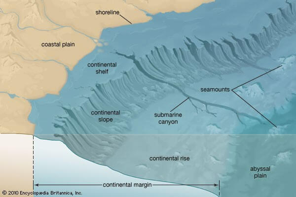
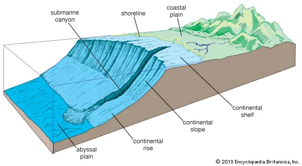
- The ocean floors can be divided into four major divisions: the Continental Shelf, the Continental Slope, the Deep Sea Plain and the Oceanic Deeps
- Continental Shelf:
- The continental shelf is a gently sloping seaward extension of the continental plate.
- These margins are occupied by relatively shallow seas and gulfs.
- The continental shelf of all oceans covers 7.5% of the total area of the oceans.
- The gradient is usually around 1° or even less.
- The shelf typically ends at a very steep slope, called the shelf break.
- The continental shelves are covered with variable thicknesses of sediments brought down by rivers, glaciers, etc.
- Massive sedimentary deposits received over a long time by the continental shelves become the source of fossil fuels, such as petroleum.
- Examples of continental shelves include South-East Asia, the Great Banks around Newfoundland, and the submerged region between Australia and New Guinea.
- The shelf is formed mainly due to –
- submergence of a part of a continent,
- relative rise in sea level, and
- sedimentary deposits brought down by rivers.
- Various types of shelves exist based on different sediments of terrestrial origin –
- glaciated shelf (surrounding Greenland),
- coral reef shelf (Queensland, Australia),
- shelf of a large river (around Nile Delta),
- shelf with dendritic valleys (at the mouth of the Hudson River), and
- shelf along young mountain ranges (shelves between Hawaiian Islands).
- Continental Slope:
- A continental slope is the slope between the outer edge of the continental shelf and the deep ocean floor.
- The continental slope is cut by submarine canyons in many locations.
- It marks the seaward edge of the continental shelf.
- The gradient of the slope region varies between 2-5°.
- It extends between the depth of 180 to 3600 metres.
- Due to their steepness and increasing distance from the land, continental slopes have very little sediment deposits and fewer sea life compared to the shelf.
- Along the base of the continental slope is a deposit of sediments forming the continental rise.
- The width of the continental rise can vary, ranging from narrow to up to 600 km in some regions.
- Continental Rise:
- The continental slope gradually loses its steepness with depth.
- When the slope reaches a level of between 0.5° and 1°, it is referred to as the continental rise.
- With increasing depth, the rise becomes virtually flat and merges with the abyssal plain.
- Deep Sea Plain / Abyssal Plain: , Deep sea basin
- Deep sea planes are gently sloping areas of the ocean basins.
- They are the flattest and smoothest regions of the world due to the terrigenous (marine sediment eroded from the land) and shallow water sediments that buries the irregular topography.
- These plains cover nearly 40% of the ocean floor.
- The depths vary between 3,000 and 6,000 m.
- Fine-grained sediments like clay and silt cover these plains.
- They have extensive submarine plateaus, ridges, trenches, beams, and oceanic islands that rise above sea level in the midst of oceans.
- Examples of oceanic islands are the Azores and Ascension Island.
- Oceanic Deep Trenches:
- Trenches are narrow, steep-sided basins in the oceans.
- They are the deepest parts of the oceans and are of tectonic origin, formed during ocean-ocean and ocean-continent convergence.
- They are 3-5 km deeper than the surrounding ocean floor.
- Trenches are located at the bases of continental slopes and along island arcs.
- They are common in the Pacific Ocean and form a ring along the western and eastern margins of the Pacific.
- The Mariana Trench in the Pacific Ocean is the deepest trench, with a depth of over 11 km.
- Other ocean deeps include the Mindanao deep, Tonga trench, and Japanese trench.
- Trenches are associated with active volcanoes and strong earthquakes, making them significant in the study of plate movements.
- 57 deeps have been explored so far, with 32 in the Pacific Ocean, 19 in the Atlantic Ocean, and 6 in the Indian Ocean.
Minor Ocean Relief Features
- Apart from the above mentioned major relief features of the ocean floor, some minor but significant features predominate in different parts of the oceans.
- Mid-oceanic ridges:
- A mid-ocean ridge is a seafloor mountain system formed by plate tectonics.
- It typically has a depth of about 2,600 meters and rises about 2,000 meters above the deepest portion of an ocean basin.
- This feature is where seafloor spreading takes place along a divergent plate boundary.
- Seamount:
- A seamount is an underwater mountain formed by volcanic activity.
- seamount does not reach the surface of the ocean.
- These can be 3,000-4,500 m tall.
- Emperor seamount, an extension of the Hawaiian Islands in the Pacific Ocean, is an example.
- Submarine Canyons:
- A submarine canyon is a steep-sided valley cut into the seabed of the continental slope.
- It sometimes extends well onto the continental shelf.
- It has nearly vertical walls.
- Occasionally, it can have canyon wall heights of up to 5 km from canyon floor to canyon rim, such as the Great Bahama Canyon.
- The Hudson Canyon is the best-known submarine canyon in the world.
- Guyots:
- Guyot or tablemount is an underwater volcanic mountain with a flat top.
- It is more than 200 meters below the surface of the sea.
- Guyots show evidence of gradual subsidence through stages to become flat-topped submerged mountains.
- More than 10,000 seamounts and guyots exist in the Pacific Ocean alone.
- Atoll:
- An atoll is a ring-shaped coral reef enclosing a lagoon.
- The coral rim of the atoll surrounds the lagoon partially or completely.
- Coral islands or cays may exist on the atoll’s rim.
- Atolls are found in warm tropical or subtropical oceans and seas where corals can grow.
- Bank:
- Banks are formed as a result of the erosional and depositional activity in the continental margins.
- They are flat-topped elevations located in shallow waters that are navigable.
- Dogger Bank in the North Sea and Grand Bank in the north-western Atlantic, Newfoundland are famous examples of banks.
- Banks are known for their productive fisheries.
- Shoal:
- A shoal is a detached elevation with shallow depths.
- Since they project out of water with moderate heights, they are dangerous for navigation.
- Reef:
- A reef is a mound or rocky elevation formed by living or dead organisms.
- Coral reefs are common in the Pacific Ocean and associated with seamounts and guyots.
- The largest reef in the world is off the coast of Queensland, Australia.
- Reefs can extend above the surface and can be dangerous for navigation.


Significance of Study of Oceanic Relief
- Ocean relief controls the motion of sea-water.
- The oceanic movement in the form of currents, in turn, causes many variations in both oceans and in the atmosphere.
- The bottom relief of oceans also influences navigation and fishing.
0 Comments