


- Periglacial Meaning – Periglacial means around or peripheral to the margins of glaciers.
- Periglacial areas are permanently frozen without permanent ice cover on the ground surface.
- Periglacial climate has mean annual temperature ranging from 1°C to -15°C and mean annual precipitation of 120 mm to 1400 mm.
- Periglacial landforms are features resulting from the action of intense frost, often combined with the presence of permafrost.
- Periglacial regions experience active geomorphological processes such as gelifraction, geliturbation, solifluction, nivation, and wind action.
- Periglacial regions have a periglacial cycle of erosion which results in the gradual flattening of the surface called cryoplanation.
- Cryoplanation is achieved primarily by the processes of intense frost action or congelifraction and solifluction or congeliturbation.
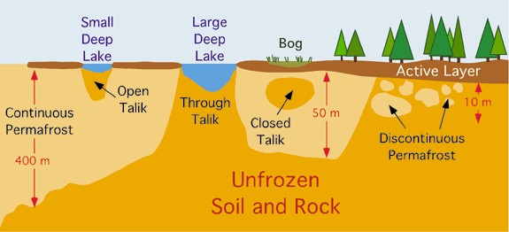
- Permafrost is a layer of soil, sediment, or rock below the ground surface that remains frozen for at least 2 years.
- Permafrost is found in about 25 percent of the Earth’s non-glaciated land surface and it influences geomorphic processes acting in this region of the world.
- Permafrost has an upper active layer that is subject to a cyclic thaw during the summer season.
Key terms
- Permafrost – Permanently frozen ground where soil temperatures have remained below 0 °C for at least 2 years
- Continuous Permafrost – Summers so cold that there is only a very superficial surface melting of the ground. It has been estimated to reach up to a depth of 1500 metres. Mean annual air temperatures of below -5 °C all year, and as low as -50 °C.
- Discontinuous Permafrost – Found is slightly warmer areas so there are islands of permanently frozen ground separated by small pockets of unfrozen less cold areas. Slightly warmer zones due to proximity of surface water (rivers, lakes, and the sea). Mean annual temps of between -1 °C and -5 °C
- Sporadic Permafrost – Found when mean annual temperature is just below 0ºC and the summer temperatures reach several degrees above but isolated pockets of permanently frozen ground remain below the surface.
- Active Layer – summer temperatures sufficient to melt the surface layer of permafrost. This layer can be very mobile. It varies in thickness depending on latitude and vegetation cover.
- Talik – Any unfrozen material within the permafrost zone.
Evolution of the Periglacial Erosion Cycle
- Stage 1: Initial surface
- Onset of periglacial conditions
- Congelifraction shatters rocks on upper slopes
- Block fields formed by angular rock fragments
- Stage 2: Early or young stage
- Rock fragments move downhill by gravity
- Talus or congeliturbate mantled slope formed at base of slope
- Nivation hollows and cryoplanation terraces formed on higher slopes
- Scarp of terraces starts retreating by frost action
- Terrace benches extended by scarp retreat
- Stage 3: Mature Stage
- Scarps destroyed by continual recession
- Only residual or for features left on summits or slopes
- Valleys and lower slopes covered with mantle of frost shattered and soliflucted materials
- Stage 4: Old Stage of cryoplanation
- Higher land further reduced and leveled by solifluction
- Debris accumulation increases in neighboring valleys and low-lying lands
- Periglacial surface converted into an almost level plain
- Finer debris transported by wind
- Loess and sand dunes formed at places
- Areas of ventifacts and lag deposits develop by blowing away of finer materials by wind
- Peltier synthesized different slope forms found in periglacial regions and arranged them in a sequence
- His hypothesis provides an overall framework for understanding slope evolution in periglacial regions
- Peltier’s hypothesis does not provide an analysis of how slope form is influenced by frost shattering and solifluction
- Adequate attention has not been paid to other processes, especially the influence of running water
- The concept of scarp recession by frost shattering and the resultant extension of terraces is an important and useful concept
- It helps to understand the formation of cryoplanation terraces, summit tors, nivation hollows, and cryopedimerts.
Periglacial Landforms – Erosional
- Freeze-thaw cycle:
- Erosion process in cold areas where ice forms.
- Water fills a crack in rock and freezes as temperature drops.
- Ice expands, pushing the crack apart and making it larger.
- When temperature rises, ice melts and fills newer parts of the crack.
- Process continues until rock breaks.
- Nivation Hollow:
- Hollows produced by snow-patch erosion.
- Generally found along hillsides in various forms.
- Extend from a few meters to 1.5 kilometers.
- May trap more snow and deepen further with more nivation, forming cirques or thermocirques.
- Classified on the basis of shape into transverse and longitudinal hollows.
- Asymmetrical Valley:
- A valley with steeper slopes on one side.
- Contrast may be caused by geologic structure or variation in erosional processes.
- Contrasts in vegetation may also exist on opposing slopes.
- Common in past and present periglacial environments, where aspect affects frost-based processes and active layer depth.
- Cryoplanation Terraces:
- Nearly horizontal bedrock surfaces or benches backed by frost-weathered bedrock cliffs
- Reminiscent of giant staircases, with alternating shallow sloping treads and steep scarps leading to extensive flat summits
- Patterned Ground:
- Sedimentary flat rocks being weathered and cracked, resulting in a patterned ground
- Frost heaving responsible for these features
- Frost Crack Polygon
- Stone Strips:
- Elongated concentration of mostly talus-like basalt rock found along a hillside or the base of a cliff
- Likely created by periglacial conditions during an Ice age, from multiple processes including frost action, surface erosion, eluviation, and mass wasting
- Shallow depth due to intense freeze and thaw cycles
- Pingo:
- Isolated dome-like low mounds or hills found in permafrost areas
- Found in arctic areas of Canada, Alaska, Greenland, and Siberia
- Ranges in height from a few to 60 meters, and diameter from a few to 300 meters
- Small pingos have closed tops whereas big pingos have open tops
- Hummocks:
- Small upstanding wrinkles on the surface of permafrost formed due to squeezing of the ground surface because of lateral pressure exerted by freezing of active layer
- Palsa:
- Special category of hummock found in swampy areas and composed of peats having thin ice layers inside
- About 10 meters in height and 10 to 20 meters in diameter
- Mostly found in the periglacial environment of arctic and subarctic areas
- Formed by frost heaving under the influence of ice segregation
Periglacial Landforms – Depositional
- BlockFields or Felsenmeer:
- Blockfields are areas covered by large angular blocks, traditionally believed to have been created by freeze-thaw action.
- Block field refers to the natural collection of large stone blocks at the flat surface of the hill tops in the periglacial areas.
- These block fields are also called blockmeer and falsenmeer. The stone blocks are formed due to frost weathering (congelifraction).
- Patterned Ground:
- Blockfields sometimes takes some geometrical shapes (like circles, polygons, nets, stripes and garlands) and are so systematically arranged are called Patterned Ground.
- Patterned Ground is erosional as well as depositional landforms in periglacial.
- Tors:
- Tors, one of the most controversial landforms, are piles of broken and exposed masses of hard rocks having a crown of rock blocks of different sizes on the top and clitters (trains of blocks) on the sides.
- The rock blocks, main components of tors, may be cuboidal, rounded, angular, elongated etc. in shape.
- They may be seated at the top of the hills, on the flanks of the hills or on flat basal platforms ranging from 6 m to 30 m in height.
- They are found in different climates varying from cold to hot and dry to humid. Though tors have developed over almost all types of rocks but they are frequently found in the regions of granites.
- Boulder Fields:
- Boulder Field is a periglacial feature that formed as a direct result of its proximity to the end moraine.
- Accumulations of rock debris in the valley floors are called stone streams or boulder fields.
- The stone is well sorting of rock debris in the stone streams.
- The upper layer consists of large and coarse debris while the lower layer is dominated by fine materials.
- Water channel is developed between the valley walls and stone stream.
- Sorting of rock debris occurs through the process of frost Heaving.
- Stone streams move downslope due to the force of gravity, frost heaving and solifluction.