


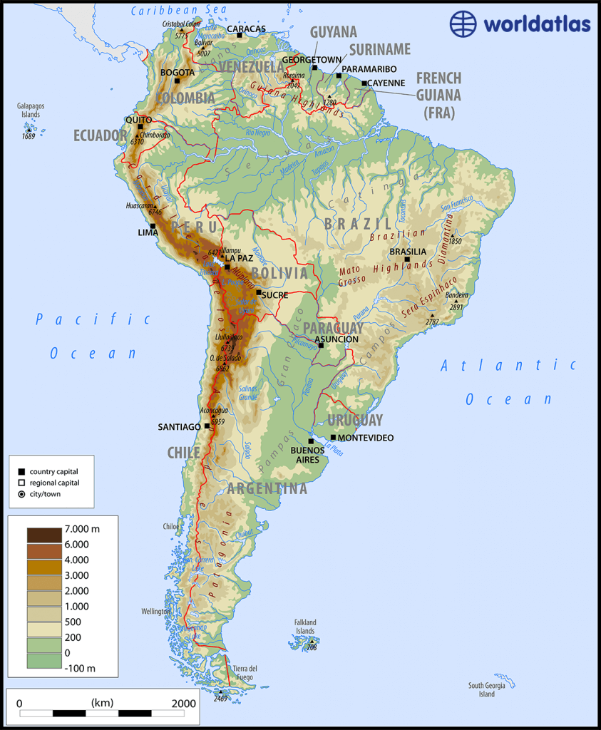
- South America is a long triangular shaped continent.
- South America is located between 12°N to 55°S latitude.
- The Equator passes through the northern part and the Tropic of Capricorn runs roughly through the middle.
- A major part of the landmass is in the tropics due to its tapering shape.
- South America is located on the west of the Prime Meridian, and the 60° meridian divides the continent lengthwise into two halves.
- It is the fourth largest continent after Asia, Africa, and North America and is two-thirds the size of Africa and six times the size of India.
- The coastline of South America is mostly smooth with few inlets except in the extreme southwest where there are fiords and many small islands.

- The Galapagos Islands and Juan Fernandez Islands are in the Pacific Ocean, Tierra del Fuego in the Southern Ocean, the Falkland Islands in the South Atlantic Ocean, and Trinidad is near Venezuela in the North Atlantic Ocean.
- The Andes is the longest mountain range in the world.
- Argentina, Chile, and Uruguay constitute the Southern Cone region because of their pointed, ice-cream-cone-like shape.
- Paraguay and Bolivia are the landlocked countries in South America.
Major Physical Divisions of South America
The Pacific coastal strip
- The Pacific coastal strip lies in the west between the ocean and the Andes.
- It is the longest coastal plain in the Atlantic world and is about 80 kilometers wide in most places.
- In some places, it is as narrow as 8 meters and has river mouths that serve as harbors.
- The south-western coast of the continent has fiords or deep inlets of the sea.
- Andes Mountains form the second-highest mountain systems in the world, next to the Himalayas.
- Mount Aconcagua, an extinct volcano, lies in Argentina.
- Mount Ojas del Salado, the highest active volcano in the world, is in Argentina.
- The Andes Mountains are part of seven countries: Venezuela, Colombia, Ecuador, Bolivia, Peru, Chile, and Argentina.
Mountain Ranges
- The Andes mountain range runs north-south from the Isthmus of Panama to the Strait of Magellan and covers the entire western coast of South America.
- It is the longest mountain range in the world and contains many volcanoes and frequent earthquakes due to being part of the Pacific Ring of Fire.
- The highest mountain in the Andes is Aconcagua at 6,962 meters, located on the Argentina-Chile border.
- The Andes consists of a chain of ranges and knots with enclosed intermontane plateaus, such as in Ecuador and Bolivia.
- The Guiana Highlands have abundant rain, tropical rainforest, and reserves of gold, diamonds, and iron ore. It is home to the world’s highest waterfall, Angel Falls, on the Caroni River.
- The Plateau of Mato Grosso is an ancient erosional plateau with savannah, cattle raising, and reserves of gold and diamonds.
- The Plateau of Borborema is semi-arid with deciduous-thorny scrub.
- The Brazilian Highlands are a lava plateau, with the Minas Gerais region being a reserve of iron and gold.
The Central Lowlands
- South America is home to two great river systems – the Amazon- the Orinoco and the Parana-Paraguay.
- The Orinoco Basin has dense tropical forests, while the northern part is covered with savanna grass called the Llanos.
- The equatorial jungle of the Amazon Basin is called the selvas, a typical tropical rain forest.
- The temperate grasslands around the mouth of the Parana-Paraguay is the pampas.
- At the source of these rivers is a region scrub forest called the Gran Chaco.
The Eastern Highlands
- Plateaus made of hard old rocks
- River Amazon separates them into Guiana Highlands to the north and Brazilian Highlands to the south
- Brazilian Highlands have steep cliffs along the east coast and slope gently towards the Central Plains
- Campos are the savanna grasslands of Brazilian Highlands
- Plateau of Matogrosso is towards the Central Lowlands
- Eastern highlands consist of Igneous and Metamorphic rocks
- Highlands are split into three regions: Brazilian Highlands, Guiana Highlands, and Patagonian Plateau
- Guiana Highlands are over 1,000 miles in length and stretch from southern Venezuela across the northern edge of South America to the tip of Brazil
- Consists of a vast plateau marked by deep gorges, tropical rain forests, numerous rivers, and waterfalls
- Famous for Angel Falls, the highest waterfall in the world at 3,212 ft (979 m) high
- Mt. Roraima is the highest point at 2,810 m
- Brazilian Highlands region is about 800 miles in length and runs through the Brazilian states of Minas Gerais, Goias, Bahia, and Sao Paulo in southeastern Brazil
- Magnificent landscape includes varied mountain ranges, namely the Serra de Mantiquiera, Serra do Paranapiataba, Serra Geral, and Serra do Mar
- Patagonian Plateau is located between the Andes and the Atlantic Ocean and about 1,000 miles in length
- Mostly rugged, barren land, famed for its beauty and striking scenery
Deserts of South America
- Patagonian Desert – the largest desert by area located in Argentina
- La Guajira Desert – a desert in northern Colombia and some of northwestern Venezuela
- Atacama – a desert in Chile, the driest place on Earth.
- Sechura Desert – a desert located along a portion of the northwestern coast of South America
- Monte Desert – in Argentina, a smaller desert above the Patagonian desert.

Drainage System of South America
- The Amazon Basin:
- Basin of River Amazon, second only to Nile river in length.
- Largest flow of water in the world, drains nearly 40% of South America’s area.
- Major tributaries include Caqueta, Jurua, Madeira, Negro, etc.
- Equatorial rainforest, navigable till Manaus, petroleum at mouth, natural rubber.
- Deforestation due to cattle ranching and soya beans field.

- The Rio de Plata Basin:
- Second in size to the Amazon.
- Main rivers forming the basin are Paraguay, Parana, and Uruguay.
- River Parana (4,879 km) rises from Minas Gerais, numerous waterfalls in Alto Parana.
- Useful for hydroelectric power (HEP), irrigation, and wheat cultivation in Pampas region.

- The Orinoco Basin:
- Third-largest drainage system of South America, rising in Southern end of Sierra Parima.
- Traverses 2,740 km to meet the Atlantic Ocean.
- Orinoco means ‘a place to paddle’, navigation possible.
- Contains ‘Region of Rapids’ in the North with enormous granite boulders.
- World’s highest waterfall Angel (979 m) situated on river Churun, a tributary of the Caroni which is further a tributary of the Orinoco.
- Flows through the llanos (savanna grasslands) of Venezuela into the North Atlantic Ocean.

- Parana River System:
- From source to junction with Paraguay is known as Alto Parana, numerous waterfalls in Alto Parana then navigable.
- Useful for HEP, irrigation, wheat cultivation in Pampas region.
- Uruguay River System:
- Joins Parana River to form Rio de la Plata estuary.
- Important for irrigation and HEP but not for navigation due to numerous rapids.
- The Sao Francisco Basin:
- Fourth-largest river system of South America, about 2,914 km in length.
- Flows within Brazil, originates North-west of the city of Belo Horizonte.
Rivers of South America

Important Lakes and Islands
- Pantanal Wetlands
- World’s largest tropical wetlands
- Spans Bolivia, Brazil, and Paraguay
- Supports millions of people and communities in the lower Rio de la Plata Basin
- Derives its name from the Portuguese word for ‘swamp’
- Largest concentration of crocodiles in the world
- High density of jaguars, which hunt caiman in the Pantanal
- Home to the largest parrot on the planet, the hyacinth macaw
- Protected areas include parts under Ramsar agreement, UNESCO World Heritage Sites, and Biosphere Reserves
- Bounded by Chiquitano dry forests, Arid Chaco dry forests, and Humid Chaco
- Less than 5% of the Pantanal is protected
- Around 95% of the Pantanal is under private ownership, mostly used for cattle grazing
Lithium Triangle
- Lithium Triangle is an intersection of Chile, Bolivia and Argentina, known for high quality salt flats.
- Salar de Uyuni in Bolivia, Salar de Atacama in Chile, and Salar de Arizaro in Argentina contains over 45%of known global lithium reserves.

- Salar de Uyuni is the world’s largest salt flat.
- It contains the world’s greatest lithium deposits.
- Bolivia aims to develop by harvesting lithium on an industrial scale from underground saltwater brines.
- Lithium can be mined from rock or processed from brine.
- Lithium is dissolved in underground saline aquifers called “brine” and pumped to the surface by wells.
- The process involves letting the brine evaporate in vast knee-deep ponds.
- The demand for electric vehicles and smart devices powered by lithium-ion batteries creates an opportunity for development.