


West Flowing Rivers of Peninsular India
- West-flowing rivers of Peninsular India are fewer and smaller than their east-flowing counterparts.
- The Narmada and the Tapi are the two major west-flowing rivers that flow through faults parallel to the Vindhyas and the Satpuras.
- Sabarmati, Mahi, and Luni are other west-flowing rivers of Peninsular India.
- Peninsular rivers that flow into the Arabian Sea do not form deltas, but only estuaries.
- The Narmada and the Tapi do not carry a good amount of silt due to the hard rocks and small tributaries.
- Rivers in Rajasthan drain into salt lakes and get lost in the sand with no outlet to the sea.
- Luni, Machhu, Rupen, Saraswati, Banas, and Ghaggar are desert rivers that flow for some distance and are lost in the desert.
Estuary
- An estuary is a body of water where freshwater from rivers and streams mixes with saltwater from the ocean
- Estuaries are places of transition from land to sea and freshwater to saltwater
- They are protected from the full force of ocean waves and storms by landforms like barrier islands or peninsulas
- Estuarine environments are highly productive, creating more organic matter than forests, grasslands, or agricultural land
- They support unique communities of plants and animals adapted to life at the margin of the sea
- Estuaries have commercial value and provide economic benefits for tourism, fisheries, and recreational activities
- They also support important public infrastructure like harbors and ports for shipping and transportation
- Estuaries filter out sediments, nutrients, and pollutants carried by water draining from uplands as it flows through wetlands like swamps and salt marshes
- Saltmarsh grasses and other estuarine plants prevent erosion and stabilize shorelines
- Mangroves are also important components of estuarine ecosystems.
Narmada River
- Narmada is the largest west flowing river of peninsular India.
- It flows westwards through a rift valley between the Vindhyan Range on the north and the Satpura Range on the south.
- Narmada basin extends over states of Madhya Pradesh, Gujarat, Maharashtra, and Chhattisgarh having an area ~1 Lakh Sq.km.
- Its total length from its source in Amarkantak to its estuary in the Gulf of Khambhat is 1,310 km.
- Jabalpur is the only important urban center in the basin.
- The river cascades 15 m into a gorge to form the Dhuan Dhar Falls near Jabalpur, popularly known as Marble Rocks.
- There are several islands in the estuary of the Narmada of which Aliabet is the largest.
- The Narmada is navigable up to 112 km from its mouth.
- The major Hydro Power projects in the basin are Indira Sagar, Sardar Sarovar, Omkareshwar, Bargi & Maheshwar.
- The right bank tributaries are the Barna, Hiran River, Tendoni River, Choral River, Kolar River, Man River, Uri River, Hatni River, Orsang River.
- The left bank tributaries are Burhner River, Banjar River, Sher River, Shakkar River, Dudhi River, Tawa River, Ganjal River, Chhota Tawa River, Kaveri River, Kundi River, Goi River, Karjan River.
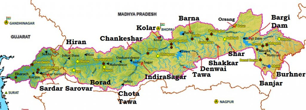
Tawa River
- The river rises from the Satpura Range of Betul in MP.
- This river is the longest tributary of River Narmada.
Tapti River
- The Tapti is the second-largest west flowing river of Peninsular India.
- It originates near Multai reserve forest in Madhya Pradesh.
- It flows for about 724 km before outfalling into the Arabian Sea through the Gulf of Cambay.
- The Tapti River basin extends over the states of Madhya Pradesh, Maharashtra, and Gujarat with an area of ~ 65,000 Sq.km.
- The basin is bounded by the Satpura range on the north, Mahadev hills on the east, Ajanta Range and the Satmala hills on the south, and by the Arabian Sea on the west.
- The hilly region of the basin is well forested, while the plains are broad and fertile areas suitable for cultivation.
- There are two well-defined physical regions in the basin: the hilly region and the plains.
- The plain covers the Khandesh areas, which are broad and fertile suitable for cultivation primarily.
- Tributaries of Tapti River
- Right Bank: the Suki, the Gomai, the Arunavati and the Aner.
- Left Bank: the Vaghur, the Amravati, the Buray, the Panjhra, the Bori, the Girna, the Purna, the Mona and the Sipna.
- Projects on Tapti River
- Hathnur Dam of Upper Tapi Project (Maharashtra)
- Kakrapar weir and Ukai Dam of Ukai Project (Gujarat)
- Girna Dam and Dahigam Weir of Girna Project (Maharashtra)
- Industry in the Tapti Basin
- Important industries in the basin are textile factories in Surat and paper and news print factory at Nepanagar.
Sabarmati River
- The Sabarmati is the name given to the combined streams of the Sabar and Hathmati rivers.
- The Sabarmati basin extends over the states of Rajasthan and Gujarat with an area of 21,674 Sq km.
- The basin is bounded by the Aravalli hills on the north and northeast, the Rann of Kutch on the west, and the Gulf of Khambhat on the south.
- The basin is roughly triangular in shape with the Sabarmati River as the base and the source of the Vatrak River as the apex point.
- The Sabarmati River originates from the Aravalli hills at an elevation of 762 m near the village of Tepur in the Udaipur district of Rajasthan.
- The total length of the river from origin to outfall into the Arabian Sea is 371 km.
- The major part of the basin is covered with agriculture, accounting for 74.68% of the total area.
- Rainfall in the Sabarmati basin varies from a meager few millimeters in Saurashtra to over 1000 mm in the southern part.
- The left bank tributaries of the Sabarmati River are the Wakal, Hathmati, and Vatrak rivers.
- The right bank tributary is the Sei river.
- Major projects completed during the plan period in the Sabarmati basin include the Sabarmati reservoir (Dharoi), Hathmati reservoir, and Meshwo reservoir project.
- Industry in Sabarmati Basin
- Gandhinagar and Ahmedabad are the important urban centers in the basin.
- Ahmedabad is an industrial city situated on the banks of Sabarmati.
- Important industries are textiles, leather and leather goods, plastic, rubber goods, paper, newsprint, automobile, machine tools, drugs and pharmaceuticals etc.
- The industrial city of Ahmedabad poses the danger of water pollution.
Mahi River
- The Mahi basin spans over Madhya Pradesh, Rajasthan, and Gujarat
- The basin covers an area of 34,842 sq km
- The Aravalli hills bound the basin to the north and northwest, Malwa Plateau to the east, Vindhyas to the south, and the Gulf of Khambhat to the west
- Mahi is a major west-flowing interstate river of India
- It originates from the northern slopes of Vindhyas in Dhar district, Madhya Pradesh at an altitude of 500m
- The river is 583km long and drains into the Arabian Sea through the Gulf of Khambhat
- 63.63% of the basin area is covered with agricultural land
- Hydro Power stations in the basin include Mahi Bajaj Sagar dam, Kadana Dam, and Wanakbori dam (Weir)
- Vadodara is the only important urban center in the basin
- Industries in the basin include cotton textiles, paper, newsprint, drugs, and pharmaceuticals. Most of these industries are located in Ratlam.
- Tributaries of Mahi:
- Som: right bank tributary, rises near Som in Udaipur district of Rajasthan, total length of 155 km, total drainage area of 8707 sq. km, Gomti & Jakham are major sub-tributaries
- Anas: left bank tributary, rises near Kalmora in Jhabua district of Madhya Pradesh, total length of 156 km, total drainage area of 5604 sq. km
- Panam: left bank tributary, rises near Bhadra in Jhabua district of Madhya Pradesh, total length of 127 km, drainage area of 2470 sq. km, joins Mahi on left bank in Panchmahal district of Gujarat.
Luni River
- The Luni River is also known as the Salt River due to its brackish water below Balotra.
- It is the only significant river basin in Western Rajasthan, which is largely an arid region.
- The river originates from the western slopes of the Aravalli ranges near Ajmer and flows southwest for 511 km in Rajasthan.
- Its tributaries mostly drain the steep northwest of the Aravalli hills and join on the left side.
- The river flows into the Rann of Kachchh in Gujarat and gets lost in the marsh.
- Unlike other rivers, the Luni tends to widen its banks instead of deepening the bed due to easily erodible soil on its banks and sand on the bed.
- The floods in the river develop and disappear rapidly, leaving no time to scour the bed.
West flowing Rivers of the Sahyadris (Western Ghats)
- Around 600 small streams originate from the Western Ghats and flow westwards into the Arabian Sea.
- The western slopes of the Western Ghats receive heavy rainfall from the south-west monsoons and are able to feed such a large number of streams.
- Only about 3% of the area flows swiftly down the steep slope, with some streams forming waterfalls.
- The Jog or Gersoppa Falls (289 m) made by the Sharavati river is the most famous waterfall in India.
- Sharavati river originates and flows entirely within the state of Karnataka.
Ghaggar River – Inland Drainage
- Some rivers in India do not reach the sea and constitute inland drainage.
- The Ghaggar is the most important river of inland drainage and is a seasonal stream that rises on the lower slopes of the Himalayas.
- It gets lost in the dry sands of Rajasthan after flowing for 465 km and was an affluent of the Indus earlier.
- Its main tributaries are the Tangri, the Markanda, the Saraswati, and the Chaitanya.
- Most of the streams draining the western slopes of the Aravalli Range dry up immediately after they enter the sandy arid areas to the west.
Mhadei river
- Mahadayi or Mhadei river is a west-flowing river that originates in Bhimgad Wildlife Sanctuary in the Western Ghats, Belagavi district of Karnataka.
- It is also known as Mandovi river in Goa, where it is joined by several streams to form the Mandovi river, which is one of the two major rivers that flow through Goa.
- The river travels for 35 km in Karnataka and 82 km in Goa before joining the Arabian Sea.
- The Kalasa-Banduri Nala project is undertaken by the Government of Karnataka with the aim of improving drinking water supply to the districts of Belagavi, Dharwad, and Gadag.
- The project involves building across Kalasa and Banduri, which are two tributaries of the Mahadayi river, to divert 7.56 TMC (thousand million cubic feet) of water to the Malaprabha river.
- The Kalasa-Banduri project was planned in 1989, but Goa has raised objections to it.
Usability of Rivers
- Source of fresh water: Rivers are a crucial source of freshwater for various purposes, including drinking water, agriculture, and domestic use. The rivers in different parts of India, such as the Ganga, the Brahmaputra, the Mahanadi, the Godavari, the Krishna, the Narmada, and the Tapi, provide freshwater for millions of people.
- Irrigation: Rivers in India are extensively used for irrigation purposes. Water from rivers is stored in dams and reservoirs to provide irrigation water to agricultural lands, enabling farmers to cultivate crops and sustain their livelihoods. Rivers like the Ganga, the Brahmaputra, the Godavari, the Krishna, the Mahanadi, and the Narmada are important for irrigation in various parts of the country.
- Hydro-electric power generation: Many rivers in India offer potential for large-scale hydro-electric power generation. Dams and hydroelectric power stations are constructed on rivers to generate electricity, which is used for various purposes, including industrial and domestic use. The rivers in the Himalayas, Vindhyas, Satpuras, Aravalis, Maikala, Chhotanagpur plateau, Meghalaya plateau, Purvachal, Western and Eastern Ghats are potential sources of hydroelectric power.
- Navigation: Rivers in India have traditionally served as important waterways for transportation of goods and people. The Ganga, the Brahmaputra, the Mahanadi, the Godavari, the Krishna, the Narmada, and the Tapi are some of the rivers that are navigable and have been used for transportation and trade in the past.
- Recreation and tourism: Rivers also offer recreational and tourism opportunities. Many rivers in India are famous for their scenic beauty, and activities such as boating, rafting, and fishing are popular among tourists and locals alike