


- Thornthwaite Climatic Classification was introduced by C. W. Thornthwaite, an American climatologist in 1931.
- The classification was initially developed for North American climates and later extended to world climates in 1933.
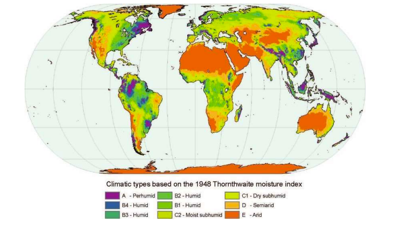
- The revised second scheme of classification was presented in 1948, which included the concept of potential evapotranspiration.
- Thornthwaite’s classification is based on two indicators, Precipitation Effectiveness (P/E) and Temperature Efficiency, and it is complex and empirical in nature.
- The world is divided into five humidity regions based on Thornthwaite’s classification: Very Humid Rain Forest (A), Humid Forest (B), Semi Humid Grassland (C), Semi-Dry Steppe (D), and Dry Desert (E).
- Vegetation is considered as an indicator of climate type in Thornthwaite’s classification.
- Each region had its own special type of vegetation as shown in the table below:
Design of Thornthwaite Climatic Classification
- Thornthwaite’s design of climate classification is a combination of three letter alphabets:
- The first alphabet used in the major climatic classification is any one of the English capital letters from A to E.
- The second letter used in the climatic classification is also an English capital alphabet superscript with a dash. It denotes thermal provinces.
- The third letter in a combination of alphabets is denoted by a set of 8 small English alphabets.
Precipitation effectiveness
- Plant growth depends not only on precipitation but also on precipitation effectiveness, measured by the P/E ratio and index.
- Thornthwaite classified five humidity regions based on P/E index: Wet-Rainforest (A), Humid-Forest (B), Subhumid-Grassland (C), Semi Arid-Steppe (D), and Arid-Desert (E).
- There are 120 probable combinations of climatic types based on precipitation effectiveness, thermal efficiency, and seasonal distribution of rainfall, but Thornthwaite depicted only 32 climatic types.
- The humidity regions are further divided into subdivisions based on the distribution of seasonal rainfall, with r indicating heavy rainfall in all seasons, s indicating scarcity of rainfall in the summer season, w indicating scarcity of rainfall in the winter season, and d indicating scarcity of rainfall in all seasons.
- For humid climates, the aridity index is measured by the moisture deficit acute during winter (w2) and moisture deficit acute during summer (s2).
- For arid climates, the humidity index is measured by the moisture surplus abundant during winter (s2) and moisture surplus abundant during summer (w2).
Temperature efficiency
- Temperature efficiency is calculated by taking the mean average temperature through years.
- Thornthwaite divided the world into six thermal provinces based on temperature efficiency.
- The thermal provinces are expressed as A’ for tropical (T/E index more than 128), B’ for subtropical (T/E index 64-127), C’ for temperate (T/E index 32-63), D’ for taiga (T/E index 16-31), E’ for tundra (T/E index 1-15), and F’ for frost (T/E index 0).
- Thornthwait was being criticized for making climatic classification complex. To make it simple, Thornthwait gave the evapotranspiration concept to derive a climatic region in 1948.
Modified System
- The modified Thornthwaite system (1948) is based on the concept of potential evapotranspiration (PE).
- PE approximates the water use of plants with an unlimited water supply.
- Thornthwaite used the three indices of precipitation effectiveness, thermal efficiency, and seasonal distribution of precipitation in his second classification but in a different way.
- Instead of vegetation, as done in the 1931 classification, Thornthwaite based his new scheme of climatic classification on the concept of potential evapotranspiration (PE).
- PE is an index of thermal efficiency and water loss because it represents the amount of transfer of both moisture and heat to the atmosphere from soils and vegetation.
Index in modified method
- Aridity Index (Ia)
- Humidity Index (Ih)
- Soil Moisture Index (Im)
- if: PET >Precipitation = Soil Moisture 0/-ve
- if: Precipitation > PET = Soil Moisture +ve
- Moist Climate determined by Aridity Index (variability in summer and winter)
- Dry climate determined by Moisture Index


Criticism of the Thornthwaite Climatic Classification
- Thornthwaite’s classification of world climates is qualitatively improved
- Classification ignores the role of prevailing winds, relative humidity, air pressure, and air masses
- Classification is most satisfactory for North America, but not for tropical and semiarid areas
- Calculation of soil moisture balance poses a basic problem due to several combinations at local and regional levels increasing complexity and obscuring clarity of classification
- Availability of data for all meteorological variables over time and space is a serious problem
- Classification is less used and of limited application due to its complex nature
- Classification ignores the role of relief and the position of the sun with reference to the incidence of solar radiation on the earth
- Current issues of global warming, climate change, and increasing incidence of extreme events do not find a place in Thornthwaite’s classification of world climates
Thornthwaite climatic division of India
- The following are the climatic division of India as per the Thornthwaite concept of Evapotranspiration.
- Per Humid( A) region of India:
- Western Ghats
- Most parts of the NorthEastern States
- Humid(B) region of India:
- Adjoining region of the Perhumid region
- Moist Sub Humid(C1) climatic region
- Narrow belt Adjoining region of the humid region of Western Ghats.
- Eastern India comprises of West Bengal and Orissa
- Dry Sub Humid(C2) regions:
- Northern Narrow belt of the Ganga basin.
- Part of Uttar Pradesh, Bihar, MP, Chhattisgarh, Jharkhand
- Western Maharastra and Southern Gujarat
- Semi-Arid(D) climatic region:
- Part of Punjab and Haryana
- Eastern part of Rajasthan, Maharashtra, Karnataka, Lenangna
- Western Pat of Tamilnadu.
- Arid climatic( E) region of India:
- Western Rajasthan
- Western Himalayan
- Rainshadow zone of western Ghats